Virginia State Route 352
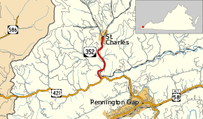
State Route 352 (SR 352) is a primary state highway in the U.S. state of Virginia. Known as St. Charles Road, the state highway runs 2.40 miles (3.86 km) from U.S. Route 421 (US 421) near Pennington Gap to SR 634 and SR 636 in St. Charles in northern Lee County.
| ||||
|---|---|---|---|---|
| St. Charles Road | ||||
 | ||||
| Route information | ||||
| Maintained by VDOT | ||||
| Length | 2.40 mi[1] (3.86 km) | |||
| Existed | 1942–present | |||
| Tourist routes | ||||
| Major junctions | ||||
| South end | ||||
| North end | ||||
| Location | ||||
| Counties | Lee | |||
| Highway system | ||||
| ||||

Route description
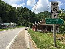
View north at the south end of SR 352 at US 421 near Pennington Gap
SR 352 begins at an intersection with US 421 on the north side of Stone Mountain and west of Pennington Gap. The state highway follows Straight Creek and a rail line north to the town of St. Charles. Within the town, the state highway reaches its northern terminus at a three-way intersection with SR 634 (Bonny Blue Road) and SR 636 (Monarch Road).[1][2]
Major intersections
The entire route is in Lee County.
| Location | mi[1] | km | Destinations | Notes | |
|---|---|---|---|---|---|
| Stone Creek | 0.00 | 0.00 | |||
| St. Charles | 2.40 | 3.86 | |||
| 1.000 mi = 1.609 km; 1.000 km = 0.621 mi | |||||
References
- "2010 Traffic Data". Virginia Department of Transportation. 2010. Retrieved 2012-01-12.
- Lee County (PDF)
- Google (2012-01-12). "Virginia State Route 352" (Map). Google Maps. Google. Retrieved 2012-01-12.
External links
| Wikimedia Commons has media related to Virginia State Route 352. |
This article is issued from Wikipedia. The text is licensed under Creative Commons - Attribution - Sharealike. Additional terms may apply for the media files.