Jhansi
Jhansi (![]()
Jhansi | |
|---|---|
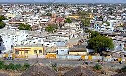 Jhansi skyline | |
Nickname(s):
| |
 Jhansi  Jhansi  Jhansi | |
| Coordinates: 25°26′55″N 78°34′11″E | |
| Country | |
| State | Uttar Pradesh |
| Region | Bundelkhand |
| District | Jhansi |
| Founded by | Raja of Orchha |
| Named for | Orchha Cantonment |
| Government | |
| • Mayor | Ram Teerth Singhal (BJP) |
| • District Magistrate | Andhra Vamsi, IAS[1] |
| • Senior Superintendent Of Police | Om Prakash Singh, IPS |
| Elevation | 285 m (935 ft) |
| Population (2011 census) | |
| • Metropolis | 505,693[2] |
| • Rank | 57 |
| • Metro | 547,638[2][3][4] |
| Language | |
| • Official | Hindi[5] |
| • Additional official | Urdu[5] |
| Time zone | UTC+5:30 (IST) |
| PIN | 284001-2-3-4 |
| Telephone code | 0510 |
| Vehicle registration | UP-93 |
| Sex ratio | ♂ 0.905 : ♀ 1.000 |
| Crude literacy | 73.9% |
| Effective literacy | 83.0% |
| Avg. summer temperature | 48 °C (118 °F) |
| Avg. winter temperature | 4.0 °C (39.2 °F) |
| Website | www |
The original walled city grew around its stone fort which crowns a neighbouring rock. The ancient name of the city was Balwantnagar. From 1817 to 1854, Jhansi was the capital of the princely state of Jhansi which was ruled by Gurjar rajas. The state was annexed by the British Governor General in 1854; Damodar Rao's claim to the throne was rejected but Rani Lakshmibai ruled it from June 1857 to June 1858.
Jhansi is well connected to all other major towns in Uttar Pradesh by road and railway networks. The National Highways Development Project has supported development of Jhansi.Jhansi is also being developed as the defence corridor by the NDA government which will boost the economy of the city and the region at the same time. Srinagar to Kanyakumari North-South corridor passes closely to Jhansi as does the East-West corridor; consequently there has been a sudden rush of infrastructure and real estate development in the city.Jhansi was adjudged the third cleanest city of Uttar Pradesh and the fastest moving city in the North Zone in Swachh Survekshan 2018 rankings. A greenfield airport development has been planned.[6] On 28 August 2015, Jhansi was selected among 98 cities for smart city initiative by Government of India.[7][8][9]
History

In the 18th century, the town of Jhansi served as the capital of a Maratha province and later the Princely State of Jhansi from 1804 till 1853, when the territory became a part of British India.
Geography and climate
Jhansi is located at 25.4333 N 78.5833 E. It has an average elevation of 284 metres (935 feet).[10] Jhansi lies on the plateau of central India, an area dominated by rocky relief and minerals underneath the soil. The city has a natural slope in the north as it is on the south western border of the vast Tarai plains of Uttar Pradesh and the elevation rises on the south. The land is suitable for species of citrus fruit and crops include wheat, pulses, peas, and oilseeds. The region relies heavily on Monsoon the rains for irrigation purposes. Under an ambitious canal project (the Rajghat canal), the government is constructing a network of canals for irrigation in Jhansi and Lalitpur and some part of Madhya Pradesh. The trade in agricultural products (including grain and oilseeds) is of great economic importance.[11] The city is also a centre of brassware manufacture.[12]
Climate
Being on a rocky plateau, Jhansi experiences extreme temperatures. Winter begins in October with the retreat of the Southwest Monsoon (Jhansi does not experience any rainfall from the Northeast Monsoon) and peaks in mid-December. The mercury generally reads about 4 degrees minimum and 21 degrees maximum. Spring arrives by the end of February and is a short-lived phase of transition. Summer begins by April and summer temperatures can peak at 47 degrees in May. The rainy season starts by the third week of June (although this is variable year to year). Monsoon rains gradually weaken in September and the season ends by the last week of September. In the rainy season, the average daily high temperature hovers around 36 degrees Celsius with high humidity. The average rainfall for the city is about 900 mm per year, occurring almost entirely within the three-and-a-half months of the Southwest Monsoon. In summer Jhansi experiences temperatures as high as 45-47 degrees and in winter the temperatures fall as low as 0-1 degrees (recorded in winter 2011).
| Climate data for Jhansi (1981–2010, extremes 1901–2012) | |||||||||||||
|---|---|---|---|---|---|---|---|---|---|---|---|---|---|
| Month | Jan | Feb | Mar | Apr | May | Jun | Jul | Aug | Sep | Oct | Nov | Dec | Year |
| Record high °C (°F) | 33.8 (92.8) |
39.4 (102.9) |
43.3 (109.9) |
46.2 (115.2) |
48.0 (118.4) |
47.8 (118.0) |
45.6 (114.1) |
42.2 (108.0) |
40.6 (105.1) |
40.6 (105.1) |
38.1 (100.6) |
33.1 (91.6) |
48.0 (118.4) |
| Average high °C (°F) | 23.4 (74.1) |
27.5 (81.5) |
34.0 (93.2) |
39.6 (103.3) |
42.4 (108.3) |
40.5 (104.9) |
34.4 (93.9) |
32.5 (90.5) |
33.5 (92.3) |
34.1 (93.4) |
30.0 (86.0) |
25.4 (77.7) |
33.1 (91.6) |
| Average low °C (°F) | 8.1 (46.6) |
11.1 (52.0) |
16.7 (62.1) |
22.6 (72.7) |
26.7 (80.1) |
27.5 (81.5) |
25.1 (77.2) |
23.9 (75.0) |
23.2 (73.8) |
19.5 (67.1) |
13.8 (56.8) |
9.5 (49.1) |
19.0 (66.2) |
| Record low °C (°F) | 1.2 (34.2) |
0.6 (33.1) |
5.3 (41.5) |
10.1 (50.2) |
15.1 (59.2) |
18.5 (65.3) |
20.3 (68.5) |
18.3 (64.9) |
16.7 (62.1) |
10.7 (51.3) |
1.1 (34.0) |
0.3 (32.5) |
0.3 (32.5) |
| Average rainfall mm (inches) | 8.5 (0.33) |
9.2 (0.36) |
10.0 (0.39) |
2.6 (0.10) |
15.5 (0.61) |
92.3 (3.63) |
238.9 (9.41) |
263.1 (10.36) |
168.3 (6.63) |
28.4 (1.12) |
5.3 (0.21) |
3.6 (0.14) |
845.6 (33.29) |
| Average rainy days | 0.8 | 1.0 | 0.8 | 0.5 | 1.7 | 5.0 | 11.4 | 12.6 | 6.9 | 1.4 | 0.5 | 0.4 | 43.0 |
| Average relative humidity (%) (at 17:30 IST) | 51 | 40 | 27 | 22 | 24 | 39 | 66 | 73 | 62 | 43 | 44 | 52 | 45 |
| Source: India Meteorological Department[13][14] | |||||||||||||
Demographics
| Historical population | ||
|---|---|---|
| Year | Pop. | ±% |
| 1871 | 30,000 | — |
| 1881 | 33,000 | +10.0% |
| 1891 | 53,779 | +63.0% |
| 1901 | 55,724 | +3.6% |
| 1911 | 70,200 | +26.0% |
| 1921 | 66,400 | −5.4% |
| 1931 | 76,700 | +15.5% |
| 1941 | 103,300 | +34.7% |
| 1951 | 127,400 | +23.3% |
| 1961 | 140,200 | +10.0% |
| 1971 | 173,300 | +23.6% |
| 1981 | 231,300 | +33.5% |
| 1991 | 300,850 | +30.1% |
| 2001 | 426,198 | +41.7% |
| 2011 | 505,693 | +18.7% |
| Source: 1871-1891 - The Imperial Gazetteer of India[15] 1901-1981 - Populstat.info[16] 1991-2011 - Citypopulation.de[17] | ||
As of 2011 Indian Census, Jhansi city had a total population of 505,693, of which 265,449 were males and 240,244 were females. Population within the age group of 0 to 6 years was 55,824. The total number of literates in Jhansi city was 373,500, which constituted 73.9% of the population with male literacy of 78.9% and female literacy of 68.3%. The effective literacy rate of 7+ population of Jhansi city was 83.0%, of which male literacy rate was 88.9% and female literacy rate was 76.6%. The Scheduled Castes and Scheduled Tribes population was 110,318 and 1,681 respectively. Jhansi city had 91150 households in 2011.[2]
The Jhansi urban agglomeration had a population of 547,638 which also included Jhansi Cantonment and Jhansi Railway Settlement.
Jhansi Cantonment
Jhansi Cantonment had a total population of 28,343 in 2011, of which 17,023 were males and 11,320 were females. Population within the age group of 0 to 6 years was 3,404. The total number of literates in Jhansi Cantonment was 23,354, which constituted 82.4% of the population. The effective literacy rate of 7+ population of Jhansi Cantonment was 93.6%. The Scheduled Castes and Scheduled Tribes population was 4,735 and 28 respectively. It had 30460 households in 2011.[3]
Jhansi Railway Settlement
Jhansi Railway Settlement had a total population of 13,602 as of 2011, of which 7,226 were males and 6,376 were females. Population within the age group of 0 to 6 years was 1,168. The total number of literates in Jhansi Railway Settlement was 10,754, which constituted 79.1%. The effective literacy rate of 7+ population of Jhansi Railway Settlement was 86.5%, of which male literacy rate was 92.1% and female literacy rate was 80.2%. The Scheduled Castes and Scheduled Tribes population was 3,373 and 38 respectively. It had 30460 households in 2011.[4]
Education
Higher education
Medical and technical colleges
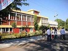
In October 2009, the Union health ministry gave approvals for setting up an institute equivalent to AIIMS, the first in Bundelkhand region and developing central agriculture university.[18]
- Maharani Laxmi Bai Medical College, established 1968[19]
- Bundelkhand Institute of Engineering & Technology
- College of Science & Engineering, Jhansi
- Government Polytechnic Jhansi[20]

Schools
- Margaret Leask Memorial English School Jhansi
- Christ the King College
- Modern Public School, Jhansi
- Rani Laxmi Bai Public School, Jhansi Cantt
- Army Public School, Jhansi
- Bhani Devi Goyal Saraswati Vidhya Mandir Inter College
Transport
The city is well connected to other parts of India by railways and major highways.
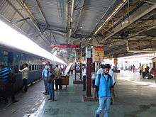
Railways

Jhansi has its own division in the North Central Railway zone of Indian Railways. It lies on the main Delhi-Chennai and Delhi-Mumbai lines. The station code is JHS. It is well connected by train services to all parts of the country, including four metropolitan cities. There are direct trains to Mumbai, Delhi, Hyderabad, Kolkata, Chennai, Bangalore, Guwahati, Visakhapatnam, Nagpur, Agra, Gwalior, Trivandrum, Indore, Ahmedabad, Udaipur, Pune, Jammu and Kashmir, Jaipur, Lucknow, Bhopal, Mahoba, Khajuraho, Gaya, Jalgaon, Bhusaval, Jabalpur, Kanpur, Allahabad, Gorakhpur, Bandra and other major towns.
History
The railway station was built by the British in the late 1880s. After a long survey of three places the current site was selected for the station. The station has a massive fort-like building painted in maroon and off white.
The station had three platforms in the beginning. Platform One is 2,525 feet (770 m) long making it the seventh longest in the world so could easily handle two trains at a time. Platforms two and three are also long enoungh to do this. The first Shatabdi Express of India started between New Delhi and Jhansi. Earlier Jhansi used to be a part of Central railways zone headquartered at Mumbai but now comes under NCR headquartered at Allahabad.
Road transport
Jhansi is located at the junction of these National Highways: National Highway 27 (India) from Gujarat to Assam; National Highway 75 (India) from Gwalior to Rewa via Chhatarpur; National Highway 44 (India) from Jammu to Kanyakumari; and National Highway 39 (India). Thus, Jhansi commands a strategic position in the roadways network as highways in five different directions diverge from it.
The towns and major cities connected to it are Datia, Gwalior, Lalitpur, Agra, New Delhi, Bhopal, Allahabad, Kanpur, Orchha, Shivpuri, Chhatarpur, Unnao Balaji, and Sagar.
The north-south and east-west corridors pass and cross each other only in Jhansi and the city is also well connected to Kanpur, Lucknow and Madhya Pradesh by road. The four lanes national highway is at the last stage of its completion, giving a boom in infrastructure and other sectors in Jhansi and nearby areas;
Air transport
Jhansi Airport is a military aviation base built in the British era used by the Indian army and political visitors. Though there are provisions for private aircraft to land, there are no civil aviation operations. There had been a demand to make it operational for commercial purposes in the 1990s and again in the 2000s. The Uttar Pradesh government announced the construction of an all new civil aviation base to support tourism in Bundelkhand in April 2011.[21] The Indian army maintains an objection to extension of the military aviation. So, the government has examined three different places other than army aviation base for the airport in Jhansi. Gwalior Airport is the nearest airport from Jhansi but has limited number of flights and facilities. Kanpur Airport is 4 hours drive from Jhansi and is well connected with other metropolitan cities in India. There are plans to develop the Jhansi airport under the UDAN scheme of regional connectivity of central government. Jhansi-Lucknow-Jhansi route was selected in UDAN 2 but the airline has not been selected yet. Jhansi-Agra and Jhansi-Khajuraho routes have been suggested by the government for UDAN 3.There are still no plans to connect Jhansi with Delhi, the national capital and other cities like Mumbai in the south.
Armed forces
The Jhansi Cantonment was the site of the accommodation for British civil and military personnel in the period of British rule in India.
Media
Amar Ujala, Dainik Jagran, Patrika,[22] and Dainik Bhaskar are some of the newspapers with online news services.
Newspapers
Many national and local newspapers are published in Jhansi in Hindi, Urdu and English:
| Newspaper | Language | Notes |
|---|---|---|
| Amar Ujala | Hindi | |
| Dainik Jagran | Hindi | |
| Daily Aziz E Hindustan | Urdu | |
| Dainik Royal Mail | Hindi | |
| Dainik Vishwa Pariwar | Hindi | |
| Hindustan | Hindi | |
| Jan Jan Jagran | Hindi | |
| Jan Seva Mail | Hindi | |
| Raftaar | Hindi | |
| Patrika[23] | Hindi | |
| Swadesh | Hindi | |
| Dainik Uddhog Hakikat | Hindi |
Radio
Jhansi has four radio station :-Radio Mirchi 98.3 FM, 92.7 BIG FM, 103.0 AIR FM and 91.1 Red FM.
Cinema
Jhansi has three cinema halls, including Elite Cinema, Khilona Cinema and Natraj Cinema.
Sport
Sports stadiums in Jhansi are Dhyanchand Stadium, Railway Stadium, and LVM Sports Place.
Notable people associated with Jhansi
- Edward Angelo (born 1870), Australian politician
- Alexander Archdale, English actor in theatre and film
- Chandra Shekhar Azad, Indian freedom fighter
- Vinod Kumar Bansal, Bansal classes, kota
- Michael Bates, English actor; Last of the Summer Wine and It Ain't Half Hot Mum
- Major Dhyan Chand, Indian Army officer and hockey player for the national team of India
- Maithilisharan Gupt, modern Hindi poet
- Hesketh Hesketh-Prichard, explorer, adventurer, big-game hunter and marksman who made a significant contribution to sniping practice within the British Army in the First World War
- Piyush Jha, film director and screenwriter and novelist of Indian origin
- Abdul Karim (the Munshi), an Indian attendant of Queen Victoria who served her during the final 15 years of her reign, gaining her maternal affection over that time.
- Subodh Khandekar, Olympian hockey player
- Tushar Khandekar, player on Indian national hockey team
- Ashok Kumar, former player on Indian national hockey team
- Rani Lakshmibai, great queen consort of Maharaja Gangadhar Rao; queen 1853-58
- Pankaj Mishra, Indian essayist and novelist
- Joy Mukherjee, Indian actor and director
- Ram Mukherjee, Indian director
- Randeep Rai,Indian television and film actor
- Sashadhar Mukherjee, producer of Hindi films
- Subodh Mukherjee, director, producer, writer of Hindi cinema; hits include Paying Guest, Munimji, Love Marriage (parts were shot at Jhansi), and Junglee
- Maharaja Gangadhar Rao, Raja of Jhansi State, 1838–53
- Dr Saumitra Rawat, surgeon, Chairman and Head, Surgical Gastroenterology and Liver Transplant, Sir Ganga Ram Hospital, New Delhi; 2015 Padma Shri
- Amit Singhal, senior vice-president at Google
- Surendra Verma, Hindi author and playwright
- Raghunath Vinayak Dhulekar MCA & Member of Parliament 1952, MLC & Speaker Vidhan Parishad 1958
Jhansi in popular culture
Jhansi in literature
Two novels by John Masters are set in the fictional town of Bhowani. According to the author, writing in the glossary to the earlier novel, Nightrunners of Bengal, Bhowani is an "imaginary town. To get a geographical bearing on the story it should be imagined to be about where Jhansi really is - 25.27 N., 78.33 E."[24] Nightrunners of Bengal is set during the Indian Rebellion of 1857 at "Bhowani" (the title alludes to the mysterious distribution of "chapatis" to village headmen which preceded the revolt). Bhowani Junction is set in 1946/47 the eve of independence. In each novel the main character is a British army officer named Colonel Rodney Savage, one of a succession of such men from the same family.
Christina Rossetti wrote a short poem about the fate of the Skene family at Jhansi during the Indian Mutiny. It is entitled "In the Round Tower at Jhansi - 8 June 1857". It was published in 1862 in the same volume as her more celebrated poem "Goblin Market". Some time afterward, Rossetti discovered that she had been misinformed about the husband and wife's suicide pact in the face of a murderous and implacable enemy ('The swarming howling wretches below' the tower walls) which is the poem's subject, but did not delete it from later editions.
Jhansi also appears as the backdrop for a portion of the George MacDonald Fraser novel Flashman in the Great Game, set just before and during the Indian Rebellion of 1857.
Jhansi in films
Movies which are filmed in or associated with Jhansi include: Jhansi Ki Rani (1953 film), Love Marriage (1959 film), Raavan (2010 film), Badrinath Ki Dulhania (2017 film), and Manikarnika: The Queen of Jhansi (2019 film).
References
- "UP govt transfers 13 IAS officers". www.aninews.in. 22 February 2020. Retrieved 26 February 2020.
- "Census of India: Jhansi city". www.censusindia.gov.in. Retrieved 23 November 2019.
- "Census of India: Jhansi Cantonment". www.censusindia.gov.in. Retrieved 23 November 2019.
- "Census of India: Jhansi Railway Settlement". www.censusindia.gov.in. Retrieved 23 November 2019.
- "52nd REPORT OF THE COMMISSIONER FOR LINGUISTIC MINORITIES IN INDIA" (PDF). nclm.nic.in. Ministry of Minority Affairs. Archived from the original (PDF) on 25 May 2017. Retrieved 18 March 2019.
- "Uttar Pradesh plans to develop Jhansi airport". igovernment.in. 4 January 2011. Archived from the original on 21 March 2012. Retrieved 3 September 2015.
- Jeelani, Mehboob (28 August 2015). "Centre unveils list of 98 smart cities; UP, TN strike it rich". The Hindu.
- "Smart City Jhansi". Mygov.in. 26 October 2015. Retrieved 24 June 2016.
- "स्मार्ट सिटी की परीक्षा में फेल हुए यूपी के 12 शहर". Amar Ujala. 30 January 2016.
- "Jhansi, India Page". fallingrain.com. Retrieved 3 September 2012.
- The Macmillan Encyclopedia; rev. ed. London: Macmillan, 1983; p. 647
- Moore, W. G. (1971) The Penguin Encyclopedia of Places. Harmondsworth: Penguin; p. 371
- "Station: Jhansi Climatological Table 1981–2010" (PDF). Climatological Normals 1981–2010. India Meteorological Department. January 2015. pp. 367–368. Archived from the original (PDF) on 5 February 2020. Retrieved 27 April 2020.
- "Extremes of Temperature & Rainfall for Indian Stations (Up to 2012)" (PDF). India Meteorological Department. December 2016. p. M217. Archived from the original (PDF) on 5 February 2020. Retrieved 27 April 2020.
- "Imperial Gazetteer of India, Volume 14, page 148". dsal.uchicago.edu. Digital South Asia Library. Retrieved 20 July 2017.
- "INDIA : urban population". www.populstat.info. Retrieved 20 July 2017.
- "Jhansi (Jhansi, Uttar Pradesh, India) - Population Statistics and Location in Maps and Charts". www.citypopulation.de. Retrieved 20 July 2017.
- "Centre clears an 'AIIMS' for Bundelkhand". Archive.indianexpress.com. Retrieved 23 August 2015.
- "Maharani Laxmibai Medical College Jhansi". Mlbmcj.in. Retrieved 24 June 2016.
- "Archived copy". Archived from the original on 9 January 2014. Retrieved 30 December 2013.CS1 maint: archived copy as title (link)
- Manjul, Tarannum (1 April 2011). "New airport at Jhansi to boost tourism". indianexpress. Retrieved 3 September 2012.
- "Jhansi Hindi News". Patrika. Retrieved 13 December 2017.
- "Jhansi News, झांसी न्यूज़, Jhansi News in Hindi, Jhansi Samachar, झांसी समाचार".
- Masters, John. Nightrunners of Bengal. (London and New York, 1951). Glossary.
External links
| Wikimedia Commons has media related to Jhansi. |

- Official website
| State symbols | |
|---|---|
| Topics |
|
| Governance |
|
| Divisions | |
| Districts |
|
| Major cities | |