Orchha
Orchha (or Urchha) is a town in Niwari district of Madhya Pradesh state, India. The town was established by Rudra Pratap Singh some time after 1501, as the seat of an eponymous former princely state of covering parts of central & north India, in the Bundelkhand region.[1] Orchha lies on the Betwa River, 80 km from Tikamgarh & 15 km from Jhansi in Uttar Pradesh.[2]
Orchha | |
|---|---|
town | |
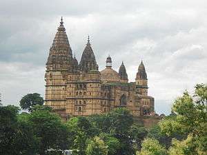    (clockwise from top) Chaturbhuj Temple, Jahangir Mahal, Raja Mahal, Lakshmi Temple | |
 Orchha  Orchha | |
| Coordinates: 25.35°N 78.64°E | |
| Country | India |
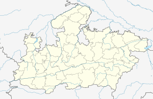
| State | Madhya Pradesh |
| District | Niwari |
| Elevation | 552 m (1,811 ft) |
| Population (2001) | |
| • Total | 8,501 |
| Languages | |
| • Official | Hindi |
| Time zone | UTC+5:30 (IST) |
| Telephone code | 07680 |
| Vehicle registration | MP-36 |
| Website | www.ramrajatempleorchha.com |
History
Orchha was founded in 1531 (the 16th century AD)[3] by the Bundela Rajput chief, Rudra Pratap Singh,[4] who became the first King of Orchha, (r. 1501-1531) and also built the Fort of Orchha.[5] The Chaturbhuj Temple was built during the reign of Emperor Akbar, by the Queen of Orchha Ganesh Kunwar (गणेश कुँवर),[6] while Raj Mandir was built by 'Raja Madhukar Shah' during his reign, 1554 to 1591.[7][8]
 Ram Raja Temple
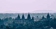 Royal Chhatris
 Purana Mandir
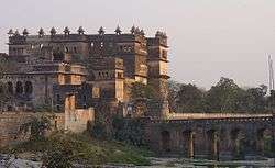
Places of tourist interest

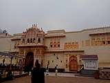
On a seasonal island on the bank of the Betwa River, which has been surrounded by a battlement wall, stands a huge palace-fort. The fort consists of several connected buildings erected at different times, the most noteworthy of which is the Raja Mahal.
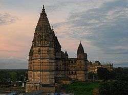
The Ram Raja Temple is built on a square base and has an almost entirely plain exterior, relieved by projecting windows and a line of delicate domes along the summit. The Jahangir Mahal is built on a rectangular base and is relieved by a circular tower at each corner surmounted by a dome, while two lines of graceful balconies supported on brackets mark the central storeys. The roof is crowned by eight large fluted domes, with smaller domes between them, connected by an ornamental balustrade. The Jahangir Mahal is considered to be a singularly beautiful specimen of Mughal architecture.[1] A point worth mentioning here is that the mother for Jahangir was also a Rajput, Jodha. It is with this in mind that the Rajput king of Orchha had built the Jahangir Mahal. There is a spectacular light and sound show in the evening hours in the Jahangir Mahal. The show displays the history of the city of Orchha and the Jahangir Mahal.[9] Chaturbhuj Temple is an old temple from the 9th century, and is noted for having one of the tallest Vimana among Hindu temples standing at 344 feet.
The Uth Khana (Camel Shelter) where the King's camels were stationed is right next to the fort and is a must-see. Tourists can also climb on the roof of the Uth Khana and get a fantastic view of Orchha town. The ruins behind the fort complex are an even greater sight. It makes a tourist travel back in time and is an integral part of a visit to Orchha. It houses the residences of various military officers, ministers (housing, roads), gunpowder factory, etc.
Numerous cenotaphs or chhatris dot the vicinity of the fort and the Betwa river. Elsewhere about the town there is an unusual variety of temples and tombs, including the Chaturbhuj temple, which is built on a vast platform of stone.[1] The more unguarded and neglected of these buildings are popular hangouts for tropical bees, wasps, and other such excitable stinging creatures.
In 2006, Orchha's buildings were being documented by the LIK Team of IIT Roorkee, India.[10]
A community radio station, Radio Bundelkhand was launched in Orchha on 23 October 2008. It is an initiative of the Development Alternatives Group. The radio station broadcasts daily programs in the Bundeli dialect and devotes significant amount of its broadcast time to local issues, culture, education and the rich tradition of Bundeli folk music. The station is available on 90.4 MHz.
 Chhatris on the bank of the Betwa River.
- Lakshmi Temple, Orchha.
 Hardaul ki Baithak Memorial at Orchha.
Demographics
As of 2001 India census,[11] Orchha had a population of 8501. Males constitute 53% of the population and females 47%. Orchha has an average literacy rate of 54%, lower than the national average of 59.5%: male literacy is 64%, and female literacy is 42%, 18% of the population is under 6 years of age.
Accessibility
Nearest Airport to Orchha is Gwalior Airport.
Orchha is 250 km and 4 hours drive from Kanpur Airport which is well connected with other metropolitan cities in India.
Orchha Railway station is Jhansi-Manikpur section of the North Central Railways. 15 km from Jhansi in Uttar Pradesh, Orchha also lies close to another popular tourist destination, Khajuraho.
Tourists who wish to visit Orchha from Khajuraho can catch the morning express which leaves at around 8 or 9 AM. Alternatively, they could also avail the afternoon express which leaves at around 12 or 1 PM. The train journey from Khajuraho is 5 hours and they will ideally have to get off at Jhansi and grab an autorickshaw or Tuk Tuk for Orchha (costs INR 400). However, if the train halts at Orchha, they can also get off at the Orchha station and grab an autorickshaw to the temple complex.
See also
References
- Chisholm, Hugh, ed. (1911). . Encyclopædia Britannica. 20 (11th ed.). Cambridge University Press. p. 170.
- "Orchha". niwari district ] website.
- Orchha Tikamgarh district Official website.
- Sen, Sailendra (2013). A Textbook of Medieval Indian History. Primus Books. p. 187. ISBN 978-9-38060-734-4.
- Mausoleum of Raja Rudra Pratap, British Library.
- Orchha Archived 7 February 2009 at the Wayback Machine British Library.
- "UQconnect, The University of Queensland". Retrieved 23 July 2016.
- Raj Mandir Archived 12 January 2012 at the Wayback Machine British Library.
- "Madhya Pradesh Destinations". Archived from the original on 22 February 1999. Retrieved 23 July 2016.
- Mission Orchha Indian Institute of Technology, Roorkee
- "Census of India 2001: Data from the 2001 Census, including cities, villages and towns (Provisional)". Census Commission of India. Archived from the original on 16 June 2004. Retrieved 1 November 2008.
- "Orchha Town". The Imperial Gazetteer of India, Vol. 19. Oxford at Clarendon Press. 1909. pp. 247–248.
- "Orchha State". The Imperial Gazetteer of India, Vol. 19. Oxford at Clarendon Press. 1909. pp. 241–247.
External links
| Wikimedia Commons has media related to Orchha. |
| Wikiquote has quotations related to: Orchha |
- Documentation of orchha buildings by IIT Roorkee
- Genealogy of the ruling chiefs of Orchha

- Travelogue and photos of Orchha
- Orchha: the erstwhile capital of Bundelkhand
- Pictures
- Orchha Photo Gallery
- Orchha Photo Gallery with over 50 Pictures 2009
- Orchha pictures on OrientalQuest
 View of Orchha from LakshmiNarayan temple
 Orchha palace mural
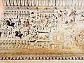 Orchha LakshmiNarayan Temple ceiling portraying Europeans
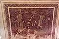 Orchha Lakshminarayana Temple: Englishmen