Gorakhpur
Gorakhpur is a city along the banks of the Rapti river in the north-eastern part or the Purvanchal region of the Indian state of Uttar Pradesh. It is situated 273 kilometres north-east of the state capital Lucknow. It is the administrative headquarters of Gorakhpur district, North Eastern Railway Zone and Gorakhpur division. With an area of 3483.8 km2,[3] the city is home to the Gorakhnath Math, a Gorakhnath temple. The city also has an Indian Air Force station, since 1963. The city also has Gita Press, Gorakhpur which since 1923 has been propagating spirituality through its literature throughout the world.[4]
Gorakhpur Gorakshapuram | |
|---|---|
City | |
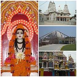 Gorakhnath Math, Taramandal, Geeta Press | |
 Gorakhpur  Gorakhpur | |
| Coordinates: 26.7637152°N 83.4039116°E | |
| Country | |
| State | Uttar Pradesh |
| District | Gorakhpur |
| Named for | Gorakhnath |
| Government | |
| • Type | Municipal Corporation of India |
| • Body | Gorakhpur Municipal corporation |
| • Mayor | Sitaram Jaiswal |
| • MP | Ravi Kishan (BJP) |
| Elevation | 84 m (276 ft) |
| Population (2011)[1] | |
| • Total | 673,446 |
| • Rank | 66 |
| Demonym(s) | Gorakhpuri, Gorakhpuriya |
| Language | |
| • Official | Hindi[2] |
| • Additional official | Urdu[2] |
| Time zone | UTC+5:30 (IST) |
| PIN | 2730xx |
| Telephone code | +91-0551 |
| Vehicle registration | UP-53 |
| Sex ratio | 1000/903 ♂/♀ |
| Avg. annual temperature | 26 °C (79 °F) |
| Avg. summer temperature | 40 °C (104 °F) |
| Avg. winter temperature | 18 °C (64 °F) |
| Website | gorakhpur |
Etymology
The name "Gorakhpur" comes from the Sanskrit Gorakshapuram, which means abode of Gorakhnath, a renowned ascetic who was a prominent saint of the Nath Sampradaya.[5][6]
Geography
Gorakhpur is situated about 100 km from the Nepal border, 193 km from Varanasi, 260 km from Patna and 273 km from Lucknow. It is one of the flood vulnerable districts in Eastern Uttar Pradesh. Data over the past 100 years show a considerable increase in the intensity and frequency of floods, with extreme events occurring every three to four years. Roughly 20% of the population is affected by floods, which are an annual occurrence in some areas, causing huge loss of life, health and livelihoods for the poor inhabitants, as well as damage to public and private property.[7]
Climate
The Köppen Climate Classification subtype for this climate is "Cfa" (Humid Subtropical Climate).[8]
| Climate data for Gorakhpur (1981–2010, extremes 1901–2012) | |||||||||||||
|---|---|---|---|---|---|---|---|---|---|---|---|---|---|
| Month | Jan | Feb | Mar | Apr | May | Jun | Jul | Aug | Sep | Oct | Nov | Dec | Year |
| Record high °C (°F) | 30.0 (86.0) |
35.4 (95.7) |
42.4 (108.3) |
44.4 (111.9) |
49.4 (120.9) |
46.5 (115.7) |
43.2 (109.8) |
39.4 (102.9) |
38.5 (101.3) |
37.4 (99.3) |
36.8 (98.2) |
30.5 (86.9) |
49.4 (120.9) |
| Average high °C (°F) | 22.0 (71.6) |
26.4 (79.5) |
32.6 (90.7) |
38.0 (100.4) |
38.3 (100.9) |
36.7 (98.1) |
32.9 (91.2) |
32.9 (91.2) |
32.7 (90.9) |
32.8 (91.0) |
29.9 (85.8) |
25.0 (77.0) |
31.7 (89.1) |
| Average low °C (°F) | 8.9 (48.0) |
11.7 (53.1) |
16.1 (61.0) |
21.4 (70.5) |
24.5 (76.1) |
26.1 (79.0) |
25.9 (78.6) |
25.9 (78.6) |
24.9 (76.8) |
20.9 (69.6) |
14.9 (58.8) |
10.4 (50.7) |
19.3 (66.7) |
| Record low °C (°F) | 1.7 (35.1) |
2.8 (37.0) |
8.3 (46.9) |
12.2 (54.0) |
16.6 (61.9) |
16.1 (61.0) |
18.1 (64.6) |
20.2 (68.4) |
17.4 (63.3) |
12.5 (54.5) |
6.7 (44.1) |
2.8 (37.0) |
1.7 (35.1) |
| Average rainfall mm (inches) | 14.4 (0.57) |
13.9 (0.55) |
7.4 (0.29) |
11.3 (0.44) |
45.2 (1.78) |
185.5 (7.30) |
383.4 (15.09) |
339.5 (13.37) |
228.8 (9.01) |
42.8 (1.69) |
2.2 (0.09) |
8.3 (0.33) |
1,282.7 (50.50) |
| Average rainy days | 1.2 | 1.3 | 0.7 | 0.9 | 3.0 | 7.0 | 13.9 | 12.4 | 9.0 | 2.1 | 0.3 | 0.6 | 52.2 |
| Average relative humidity (%) (at 17:30 IST) | 68 | 55 | 40 | 32 | 42 | 57 | 75 | 77 | 76 | 68 | 66 | 69 | 61 |
| Source: India Meteorological Department[9][10] | |||||||||||||
Demographics
As of 2011 Indian Census, Gorakhpur had a total population of 673,446, of which 353,907 were males and 319,539 were females. It has a sex ratio of 903 females per 1000 males. Population within the age group of 0 to 6 years was 69,596. Gorakhpur had a literary rate of 75.2%, of which male literacy was 79.4% and female literacy was 70.6%. The effective literacy rate of 7+ population of Bahraich was 83.9%, of which male literacy rate was 88.7% and female literacy rate was 78.6%. The Scheduled Castes and Scheduled Tribes population was 62,728 and 2,929 respectively. Gorakhpur had 112,237 households in 2011.[1]
Transport
Railways
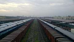
Gorakhpur is connected through rail network and Gorakhpur railway station.
The station offers Class A-1 railway station facilities. On 6 October 2013, Gorakhpur has the world's Longest Railway platform, after inauguration of the remodelled Gorakhpur Yard, with a stretch of around 1,355.40 metres (0.84 mi).[12][13][14][15]
Gorakhpur is the headquarters of North Eastern Railways.[16]
Air
An Air Force station of Indian Air Force was established in Gorakhpur in 1963 and extended for public transport. Named Mahayogi Gorakhnath Airport.[17]
Metro
The proposed Gorakhpur metro system will consist of two corridors, Shyam Nagar-Suba Bazar and Gularhia- Kachehri chauraha. Both will cover a distance of 27.41 km (17.03 mi) and both corridor will have 27 metro station.
Education
Gorakhpur has two universities named Deen Dayal Upadhyay Gorakhpur University and Madan Mohan Malaviya University of Technology, two medical college named Baba Raghav Das Medical College and AIIMS and a sports college named Veer Bahadur Singh Sports College.
Sports
- Veer Bahadur Singh Sports College, Gorakhpur
- Syed Modi Railway Stadium
- Regional Sports Stadium
Notable people
- Yogi Adityanath, Chief Minister of Uttar Pradesh
- Leopold Amery, British Cabinet Minister
- Premindra Singh Bhagat, Recipient of Victoria Cross
- Ram Upendra Das, Economist
- Amrapali Dubey, actress
- Ravi Dubey, actor
- Mahmood Farooqui Indian writer, artist and director
- Firaq Gorakhpuri, writer
- Narendra Hirwani, international cricket player
- Anurag Kashyap, filmmaker
- Kafeel Khan, lecturer (currently suspended) at BRD Medical college
- Ravi Kishan, Member of Parliament from Gorakhpur Lok Sabha constituency
- Syed Modi, badminton player, winner of Arjuna Award
- Capt. Mahendra Nath Mulla, MVC, Officer of the Indian Navy
- Kamlesh Paswan, politician
- Subrata Roy, Indian businessman, founder of Sahara India Pariwar
- Asit Sen, Bollywood actor
- Jimmy Shergill, actor
- Saurabh Shukla, actor
- Shri Prakash Shukla, Indian contract killer
- Shiv Pratap Shukla, Indian politician and social worker
- Amar Shahid Bandhu Singh, freedom fighter
- Kedarnath Singh, poet, critic
- Lilavati Singh, educator
- Vir Bahadur Singh, former Chief Minister of Uttar Pradesh
- Prem Maya Sonir, hockey player
- Hari Shankar Tiwari, Indian politician
- Paramahansa Yogananda, Yoga guru, founder of Self-Realization Fellowship/Yogoda Satsanga Society of India
- Hari Shankar Tiwari
- Amarmani Tripathi
- Hari Shankar Tiwari
- Prem Maya Sonir, former captain of Indian hockey team
- Chitra Tripathi TV news anchor
See also
- Gorakhpur Cantonment railway station
- Ramgarh Tal Lake
- Deoria District
References
- "Census of India: Gorakhpur". www.censusindia.gov.in. Retrieved 16 December 2019.
- "52nd REPORT OF THE COMMISSIONER FOR LINGUISTIC MINORITIES IN INDIA" (PDF). nclm.nic.in. Ministry of Minority Affairs. Archived from the original (PDF) on 25 May 2017. Retrieved 23 February 2019.
- "District Gorakhpur | The city of Historical and Cultural importance | India". Retrieved 22 May 2020.
- "gita press gorakhpur". Gita Press, Gorakhpur.
- "History – Origin of Name". gorakhpur.nic.in. Retrieved 13 January 2020.
- "Mallinson, James (2011) 'Nāth Saṃpradāya.' In: Brill Encyclopedia of Hinduism Vol. 3. Brill, pp. 407–428" (PDF). Retrieved 11 January 2020.
- Integrating climate change concerns into disaster management planning: The case of Gorakhpur, India by Shiraz A. Wajih and Shashikant Chopde, the Climate and Environment Knowledge Network, 2014
- "Gorakhpur, India Köppen Climate Classification (Weatherbase)". Weatherbase. Retrieved 11 January 2020.
- "Station: Gorakhpur Climatological Table 1981–2010" (PDF). Climatological Normals 1981–2010. India Meteorological Department. January 2015. pp. 297–298. Archived from the original (PDF) on 5 February 2020. Retrieved 27 April 2020.
- "Extremes of Temperature & Rainfall for Indian Stations (Up to 2012)" (PDF). India Meteorological Department. December 2016. p. M216. Archived from the original (PDF) on 5 February 2020. Retrieved 27 April 2020.
- "C-1 Population By Religious Community - Uttar Pradesh". census.gov.in. Retrieved 16 December 2019.
- "Gorakhpur gets world's largest railway platform | Lucknow News - Times of India".
- "Archived copy". Archived from the original on 2 October 2013. Retrieved 1 September 2013.CS1 maint: archived copy as title (link)
- "Gorakhpur railway station's remodelling in final stage | Varanasi News - Times of India".
- "Gorakhpur gets world's longest railway platform". अमर उजाला (Amar Ujala). 13 February 2012. Retrieved 7 October 2013.
- North Eastern Railway. Ner.indianrailways.gov.in. Retrieved on 21 October 2011.
- No. 105 Helicopter Unit. Indian Air Force