Jalgaon
Jalgaon (![]()

Jalgaon | |
|---|---|
City | |
 Jalgaon Skyline Nightview | |
| Nickname(s): Banana City and Gold City | |
 Jalgaon  Jalgaon | |
| Coordinates: 20.997984°N 75.566711°E | |
| Country | |
| State | Maharashtra |
| Region | Khandesh |
| District | Jalgaon |
| Government | |
| • Type | Municipal Corporation |
| • Body | Bharatiya Janata Party |
| • MP | Unmesh Bhaiyyasaheb Patil |
| • MLA | Suresh Damu Bhole |
| • Mayor | Bhartitai Kailas Sonawane |
| • Municipal Commissioner | Uday Tekale |
| Area | |
| • Total | 68 km2 (26 sq mi) |
| Elevation | 225 m (738 ft) |
| Population (2011) | |
| • Total | 4,60,668 |
| • Rank | 62nd |
| • Density | 6,800/km2 (18,000/sq mi) |
| Demonym(s) | Jalgaonkar |
| Language | |
| • Official | Marathi |
| Time zone | UTC+5:30 (IST) |
| Telephone code | 0257 |
| Vehicle registration | MH-19 |
| Website | www |
Transport
Roadways
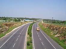
National Highway no.6 (Surat-Dhule-Amravati-Nagpur) passes through the city. Important cities of the district are also connected by state highways.
Airways
Jalgaon airport was built in 1973 by the Public Works Department.[3] The Jalgaon Municipal council took over its operations in April 1997 and handed it over to the Maharashtra Airport Development Company in April 2007.[4] The Government of Maharashtra signed a Memorandum of Understanding (MoU) with The Airports Authority of India (AAI) to upgrade the existing airfield in July 2009.[5] The then President of India, Pratibha Patil laid the foundation stone for the development and expansion of the Jalgaon airport in June 2010.[6] Jalgaon has two flights one for Mumbai and one for Ahemdabad operated by Trujet airlines.
Railways
The city is served by Jalgaon Junction railway station. The railway connects the region to New Delhi, Mumbai and Kolkata.
Education
Educational facilities include:
University
Under/post-graduate colleges
Engineering/polytechnic colleges
- University Department of Chemical Technology
- Government College of Engineering
- Government Polytechnic
- G. H. Raisoni College of Engineering and Management
- Shram Sadhana Trust College of Engineering
- College of Engineering & Technology North Maharashtra Knowledge City
Economy
Jalgaon has a Maharashtra Industrial Development Corporation (MIDC) area with manufacturing units. The town is known for its gold jewellery business and ornament market.
Notable people
- Bahinabai Chaudhari (1880–1951), a farmer whose poetry, published posthumously, helped popularize the Ahirani dialect.
- Balkavi Thombre (1890–1918), a Marathi poet.
- Madhukar Rao Chaudhary (5 June 1919 – 8 July 2010), socialist, Gandhian leader. He was the Speaker of Maharashtra Legislative Assembly
- Dr. Gurumukh Jagwani 2 times MLC from District, originally from Pakistan but settled in India.
- Suresh Jain, 8 times MLA from city and X minister of Govt of Maharashtra.
- Ishwarlal Jain (Babuji) Three times MLA and 6 years Rajya Sabha MP. NCP Party Treasurer.
- Bhavarlal Jain (1937–2016), an entrepreneur who founded Jain Irrigation Systems.
- Haribhau Jawale, 3 term MLA and Member of Parliament from Raver.
- Eknath Khadse (1952–present), a politician of the Bharatiya Janata Party.
- Girish Mahajan (1960–present), a politician and cabinet minister in Maharashtra.
- Namdeo Dhondo Mahanor (1942–present), a Marathi poet and recipient of the Padma Shri award.
- Ujjwal Nikam, a public prosecutor who has worked on high-profile murder and terrorism cases.
- Gulab Raghunath Patil (1966–present) Senior Leader of Shiv Sena and Minister in Maharashtra.
- Pratibha Patil (1934–present), a former president of India (2007–12) and governor of Rajasthan (2004–07).
Climate
| Jalgaon | ||||||||||||||||||||||||||||||||||||||||||||||||||||||||||||
|---|---|---|---|---|---|---|---|---|---|---|---|---|---|---|---|---|---|---|---|---|---|---|---|---|---|---|---|---|---|---|---|---|---|---|---|---|---|---|---|---|---|---|---|---|---|---|---|---|---|---|---|---|---|---|---|---|---|---|---|---|
| Climate chart (explanation) | ||||||||||||||||||||||||||||||||||||||||||||||||||||||||||||
| ||||||||||||||||||||||||||||||||||||||||||||||||||||||||||||
| ||||||||||||||||||||||||||||||||||||||||||||||||||||||||||||
| Climate data for Jalgaon City (1981–2010, extremes 1969–2008) | |||||||||||||
|---|---|---|---|---|---|---|---|---|---|---|---|---|---|
| Month | Jan | Feb | Mar | Apr | May | Jun | Jul | Aug | Sep | Oct | Nov | Dec | Year |
| Record high °C (°F) | 35.9 (96.6) |
41.2 (106.2) |
43.9 (111.0) |
47.2 (117.0) |
48.4 (119.1) |
46.6 (115.9) |
43.9 (111.0) |
40.4 (104.7) |
39.8 (103.6) |
39.5 (103.1) |
37.7 (99.9) |
36.4 (97.5) |
48.4 (119.1) |
| Average high °C (°F) | 30.3 (86.5) |
32.8 (91.0) |
37.6 (99.7) |
41.2 (106.2) |
42.4 (108.3) |
38.0 (100.4) |
32.8 (91.0) |
30.8 (87.4) |
32.8 (91.0) |
34.5 (94.1) |
32.7 (90.9) |
30.4 (86.7) |
34.7 (94.5) |
| Average low °C (°F) | 12.2 (54.0) |
13.9 (57.0) |
18.6 (65.5) |
23.9 (75.0) |
26.9 (80.4) |
25.9 (78.6) |
24.3 (75.7) |
23.5 (74.3) |
23.1 (73.6) |
19.4 (66.9) |
14.8 (58.6) |
11.9 (53.4) |
19.9 (67.8) |
| Record low °C (°F) | 1.7 (35.1) |
3.9 (39.0) |
8.2 (46.8) |
13.1 (55.6) |
19.0 (66.2) |
19.3 (66.7) |
18.8 (65.8) |
17.1 (62.8) |
12.3 (54.1) |
9.5 (49.1) |
5.0 (41.0) |
1.7 (35.1) |
1.7 (35.1) |
| Average rainfall mm (inches) | 4.2 (0.17) |
1.6 (0.06) |
4.5 (0.18) |
2.6 (0.10) |
10.8 (0.43) |
145.5 (5.73) |
207.0 (8.15) |
195.0 (7.68) |
116.2 (4.57) |
45.5 (1.79) |
11.3 (0.44) |
2.4 (0.09) |
746.5 (29.39) |
| Average rainy days | 0.3 | 0.3 | 0.4 | 0.3 | 0.9 | 6.9 | 12.3 | 10.9 | 6.6 | 2.7 | 0.6 | 0.3 | 42.5 |
| Average relative humidity (%) (at 17:30 IST) | 40 | 33 | 25 | 21 | 25 | 47 | 67 | 74 | 62 | 43 | 38 | 41 | 43 |
| Source 1: India Meteorological Department[8][9] | |||||||||||||
| Source 2: Government of Maharashtra[10] | |||||||||||||
See also
- Make in Maharashtra
- Jalgaon Zilla Parishad
- Jalgaon Municipal Corporation
- Jain Irrigation Systems
References
- "Banana republic Jalgaon bears fruit". The Indian Express. 18 June 2004. Retrieved 3 January 2011.
- Chisholm, Hugh, ed. (1911). . Encyclopædia Britannica. 15 (11th ed.). Cambridge University Press. p. 771.
- "Airstrips in Maharashtra". Maharashtra Public Works Department. Retrieved 3 February 2012.
- "President inaugurates Jalgaon airport". Newstrackindia.com. 23 March 2012. Archived from the original on 7 April 2014. Retrieved 25 March 2012.
- "MADC - Projects". Maharashtra Airport Development Company. Archived from the original on 26 February 2012.
- "President lays foundation stone for Jalgaon airport". Zeenews.com. 13 June 2010. Archived from the original on 16 June 2013. Retrieved 4 February 2012.
- "Government medical college & Hospital of Jalgaon". gmcjalgaon.com. 10 April 2020. Retrieved 10 April 2020.
- "Station: Jalgaon Climatological Table 1981–2010" (PDF). Climatological Normals 1981–2010. India Meteorological Department. January 2015. pp. 347–348. Archived from the original (PDF) on 5 February 2020. Retrieved 5 April 2020.
- "Extremes of Temperature & Rainfall for Indian Stations (Up to 2012)" (PDF). India Meteorological Department. December 2016. p. M143. Archived from the original (PDF) on 5 February 2020. Retrieved 5 April 2020.
- "Climate". Government of Maharashtra. Retrieved 5 April 2020.
External links
Jalgaon district topics | ||
|---|---|---|
| History |
|  |
| Tehsils | ||
| Lok Sabha constituencies | ||
| Vidhan Sabha constituencies | ||
| Towns and villages |
| |
| Places of interest | ||
| Topics | |||||||||||||
|---|---|---|---|---|---|---|---|---|---|---|---|---|---|
| Regions | |||||||||||||
| Divisions and Districts |
| ||||||||||||
| Million-plus cities in Maharashtra | |||||||||||||
| Other cities with municipal corporations | |||||||||||||
Portal:India | |||||||||||||