Vidisha district
Vidisha District (विदिशा) is in Madhya Pradesh state, in central India. The city of Vidisha is the administrative headquarters of the district.
Vidisha district | |
|---|---|
District of Madhya Pradesh | |
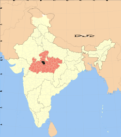 Location of Vidisha district in Madhya Pradesh | |
| Country | India |
| State | Madhya Pradesh |
| Headquarters | Vidisha |
| Area | |
| • Total | 7,371 km2 (2,846 sq mi) |
| Population | |
| • Total | 1,458,875 |
| • Density | 200/km2 (510/sq mi) |
| Time zone | UTC+05:30 (IST) |
Geography
The district is bounded by the districts of Ashoknagar to the northeast, Sagar to the east, Raisen to the south, Bhopal to the southwest, and Guna to the northwest.[1]
Vidisha district lies on the Vindhyachal Plateau off the main Vindhyachal Range. The plateau slopes from south to north and is drained by a number of rivers – the Betwa, the Bina and the Sindh. These rivers flow between spur fanges of the Vindhyachal Range, that spread out on the Malwa Plateau.[2]
The district lies between 230 20’ and 240 22' north latitudes, and 77016’ and 78018’ east longitudes. It covers an area of 7,371 km2.[2]
The district is home to the historic city of Besnagar and the Buddhist stupa at Sanchi.[1]
History
The district was created as "Bhilsa District" in 1904 by joining the tehsils of Vidisha (also known as Bhilsa) and Basoda, but not Basoda State, which were then part of Gwalior state. After India's independence in 1947, the former princely state of Gwalior became part of Madhya Bharat state, which was formed in 1948. The Bhilsa District was enlarged in 1949 by the addition of the small princely state of Kurwai State. The district took its present form in 1956, when Madhya Bharat state, Bhopal State, and the tehsil of Sironj, then part of Rajasthan state and previously part of the princely state of Tonk, were both merged into Madhya Pradesh state. Sironj tehsil and the small pargana of Piklone from Bhopal state were merged into Vidisha District.[2]
Demographics
According to the 2011 census Vidisha District has a population of 1,458,875,[3] roughly equal to the nation of eSwatini[4] or the US state of Hawaii.[5] This gives it a ranking of 341st in India (out of a total of 640).[3] The district has a population density of 198 inhabitants per square kilometre (510/sq mi) .[3] Its population growth rate over the decade 2001-2011 was 20.03%.[3] Vidisha has a sex ratio of 897 females for every 1,000 males,[3] and a literacy rate of 72.08%.[3]
At the time of the 2011 Census of India, 95.16% of the population in the district spoke Hindi and 4.57% Urdu as their first language.[6]
| Historical population | ||
|---|---|---|
| Year | Pop. | ±% p.a. |
| 1901 | 227,998 | — |
| 1911 | 296,966 | +2.68% |
| 1921 | 348,047 | +1.60% |
| 1931 | 345,818 | −0.06% |
| 1941 | 383,347 | +1.04% |
| 1951 | 386,075 | +0.07% |
| 1961 | 489,213 | +2.40% |
| 1971 | 658,427 | +3.02% |
| 1981 | 783,098 | +1.75% |
| 1991 | 970,388 | +2.17% |
| 2001 | 1,214,857 | +2.27% |
| 2011 | 1,458,875 | +1.85% |
| source:[7] | ||
References
- "Vidisha". mponline. Retrieved 19 August 2010.
- "Vidisha". District administration. Retrieved 19 August 2010.
- "Vidisha District Population Census 2011, Madhya Pradesh literacy sex ratio and density". Census Organisation of India. 2011. Archived from the original on 3 January 2013.
- US Directorate of Intelligence. "Country Comparison:Population". Retrieved 1 October 2011.
Swaziland 1,370,424
- "2010 Resident Population Data". U. S. Census Bureau. Retrieved 30 September 2011.
Hawaii 1,360,301
- 2011 Census of India, Population By Mother Tongue
- Decadal Variation In Population Since 1901
External links
| Wikimedia Commons has media related to Vidisha district. |
Places adjacent to Vidisha district | ||||||||||
|---|---|---|---|---|---|---|---|---|---|---|
| ||||||||||
| State symbols | |
|---|---|
| Topics |
|
| Governance |
|
| Divisions | |
| Districts |
|
| Major cities | |