Homestead, Florida
Homestead is a city within Miami-Dade County in the U.S. state of Florida, between Biscayne National Park to the east and Everglades National Park to the west. Homestead is primarily a Miami suburb and a major agricultural area. It is a principal city of the Miami metropolitan area, which was home to an estimated 6,012,331 people at the 2015 census.
Homestead, Florida | |
|---|---|
| City of Homestead | |
 | |
 Flag  Seal | |
| Motto(s): "Gateway to Everglades & Biscayne National Parks" & "Discover The Opportunities" | |
 Location in Miami-Dade County and the U.S. state of Florida | |
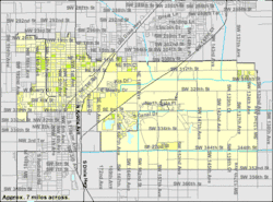 U.S. Census Bureau map showing city limits | |
| Coordinates: 25°28′16.28″N 80°28′5.24″W | |
| Country | |
| State | |
| County | |
| Incorporated | February 8, 1913 |
| Government | |
| • Type | Council-Manager |
| • Mayor | Stephen D Losner |
| • Vice Mayor | Patrica Fairclough-Staggers |
| • Councilmembers | Larry Roth, Sean Fletcher, Stephen Shelley, and Jenifer Bailey |
| • City Manager | George Gretsas |
| • City Clerk | Elizabeth Sewell |
| Area | |
| • Total | 15.61 sq mi (40.44 km2) |
| • Land | 15.14 sq mi (39.20 km2) |
| • Water | 0.48 sq mi (1.23 km2) 0.63% |
| Elevation | 3 ft (1 m) |
| Population (2010) | |
| • Total | 60,512 |
| • Estimate (2019)[2] | 69,523 |
| • Density | 4,492.04/sq mi (1,734.41/km2) |
| Time zone | UTC-5 (Eastern (EST)) |
| • Summer (DST) | UTC-4 (EDT) |
| ZIP codes | 33000-33099 |
| Area code(s) | 305 and 786 |
| FIPS code | 12-32275[3] |
| GNIS feature ID | 0284214[4] |
| Website | www.CityOfHomestead.com |
Homestead was incorporated in 1913 and is the second oldest city in Miami-Dade County next to the city of Miami. It is located approximately 35 miles (56 km) southwest of Miami, and 25 miles (40 km) northwest of Key Largo. The name originates from when the Florida East Coast Railway extension to Key West was being built. The rail line was passing through an area opened up for homesteading, and as the construction camp at the end of the line did not have a particular name, construction materials and supplies for the workers were consigned to "Homestead Country", shortened to "Homestead" by the engineers who mapped the area.[5] The population was 60,512 at the 2010 census. Homestead and neighboring South Miami-Dade County communities bore the brunt of Category 5 Hurricane Andrew on August 24, 1992.
The city of Homestead is located near the southern terminus of the Homestead Extension of Florida's Turnpike where it ends at its junction with U.S. 1. Homestead is immediately north and east of Florida City, and these two cities comprise the greater Homestead-Florida City area. Some of the notable unincorporated communities in the area are Redland, Leisure City, Naranja, and Princeton.
Geography
Homestead is located at 25°28′16″N 80°28′5″W (25.471190, -80.468122).[6]
According to the United States Census Bureau, the city has a total area of 14.4 square miles (37 km2). 14.3 square miles (37 km2) of it is land and 0.1 square miles (0.26 km2) of it (0.63%) is water.
Homestead is a small-sized city. At its greatest north-south points – along SW 137th Avenue (Speedway Boulevard) – its city limits extend only 4 miles (6 km) – from SW 288th Street (Biscayne Drive) at the north end to (theoretical) SW 352nd Street at the south end. At its greatest east-west points – along SW 328th Street (North Canal Drive / Lucy Street) – its city limits extend 6 miles (10 km) – from (theoretical) SW 132nd Avenue at the east end to SW 192nd Avenue at the west end. U.S. 1 – known as Homestead Boulevard within the city limits – extends through a rather narrow northeast / southwest corridor of the city from SW 304th Street (Kings Highway) at the north end to SW 328th Street (Lucy Street) at the south end. It is at this point at the south end that Homestead and Florida City share a common border. (North of the north end at SW 304th Street is known as Unincorporated Miami-Dade County, but it is locally known as the community of Leisure City).
Major east-west streets within Homestead include SW 304th Street / NE & NW 15th Street (Kings Highway), SW 312th Street / NE & NW 8th Street (Campbell Drive), SW 320th Street (Mowry Drive), SW 328th Street / SE & SW 8th Street (North Canal Drive / Lucy Street), and SW 344th Street / SE 24th Street (Palm Drive).
The original Homestead Air Force Base was once located several miles to the northeast of Homestead, but due to annexation of formerly unincorporated land immediately to the east and northeast of the original city limits during the late-1990s the city and the far southwestern perimeter of the (now) Homestead Air Reserve Base share a common border for a small portion along SW 137th Avenue (Speedway Boulevard).
A noteworthy tourist attraction within Leisure City is Coral Castle, built by a jilted lover, Edward Leedskalnin, over the course of 28 years from 1923 to 1951.[7] The Fruit and Spice Park is also of interest.
Climate
Homestead experiences a tropical savanna climate (Köppen climate classification Aw) that borders on a tropical monsoon climate (Am). Summers are hot and humid and high temperatures average between 88° and 92 °F (31° to 33 °C). Winters are warm and dry. The all-time record high temperature is 100 °F (38 °C), on 21 July 1942. Lows in summer average between 70° and 75 °F (21° to 24 °C), with low temperatures in all times of year averaging 5–15 degrees cooler than coastal Miami, mainly because of its inland and rural location. In winter, the area sees cold fronts bring cold weather for short periods from November to March. The lowest temperature ever recorded is 26 °F (-3 °C), on 13 December 1934, which was recorded at Homestead Air Force Base, some 10 miles east of the town. High temperatures in winter average between 68° and 80 °F (18° to 26 °C), and lows average between 57° and 64 °F (8° to 14 °C).[8] Summer is the season when most of the rain occurs. Homestead has a wet season lasting from mid-May to early October. The dry season sees little if any rain, with most of it coming with the passing of cold fronts. Snow flurries were reported to have been observed in the air at Homestead Air Force Base, on January 20, 1977, and marked the farthest south that snow flurries have ever been reported in the lower 48 United States.
| Climate data for Miami Homestead General Aviation Airport (1981–2010) | |||||||||||||
|---|---|---|---|---|---|---|---|---|---|---|---|---|---|
| Month | Jan | Feb | Mar | Apr | May | Jun | Jul | Aug | Sep | Oct | Nov | Dec | Year |
| Average high °F (°C) | 76.5 (24.7) |
78.2 (25.7) |
80.2 (26.8) |
83.4 (28.6) |
86.6 (30.3) |
89.3 (31.8) |
90.5 (32.5) |
90.8 (32.7) |
89.3 (31.8) |
85.5 (29.7) |
80.9 (27.2) |
77.5 (25.3) |
84.1 (28.9) |
| Daily mean °F (°C) | 65.8 (18.8) |
67.3 (19.6) |
69.9 (21.1) |
72.9 (22.7) |
77.2 (25.1) |
80.8 (27.1) |
81.9 (27.7) |
82.4 (28.0) |
81.2 (27.3) |
77.7 (25.4) |
72.0 (22.2) |
67.8 (19.9) |
74.7 (23.7) |
| Average low °F (°C) | 55.0 (12.8) |
56.5 (13.6) |
59.6 (15.3) |
62.4 (16.9) |
67.9 (19.9) |
72.3 (22.4) |
73.2 (22.9) |
73.9 (23.3) |
73.1 (22.8) |
69.8 (21.0) |
63.1 (17.3) |
58.2 (14.6) |
65.4 (18.6) |
| Average precipitation inches (mm) | 1.42 (36) |
2.16 (55) |
2.50 (64) |
3.05 (77) |
5.87 (149) |
9.37 (238) |
6.82 (173) |
9.24 (235) |
8.40 (213) |
6.51 (165) |
2.59 (66) |
1.59 (40) |
59.52 (1,511) |
| Source: National Weather Service[9] | |||||||||||||
Hurricanes
In August 1992, the Category 5 hurricane Andrew devastated the town, as well as nearby Homestead Air Force Base. Hurricane Katrina caused flooding in Homestead in August 2005.[10] The following October, Hurricane Wilma damaged light poles, grandstands, garages, and sections of catch fence at the Homestead–Miami Speedway, a motor racetrack built in the years following Hurricane Andrew.[11] After Hurricane Wilma, a Homestead man was killed in a tractor accident while clearing debris.[12]
When Hurricane Irma struck Florida in September 2017, parts of Homestead lost electric power. South Dade Center, a low-income housing project for farmworkers, was flooded with rainwater. Residents were without electricity and waste collection for about a week without relief.[13]
Demographics
| Historical population | |||
|---|---|---|---|
| Census | Pop. | %± | |
| 1920 | 1,307 | — | |
| 1930 | 2,319 | 77.4% | |
| 1940 | 3,154 | 36.0% | |
| 1950 | 4,573 | 45.0% | |
| 1960 | 9,152 | 100.1% | |
| 1970 | 13,674 | 49.4% | |
| 1980 | 20,668 | 51.1% | |
| 1990 | 26,866 | 30.0% | |
| 2000 | 31,909 | 18.8% | |
| 2010 | 60,512 | 89.6% | |
| Est. 2019 | 69,523 | [2] | 14.9% |
| U.S. Decennial Census[14] | |||
| Homestead Demographics | |||
|---|---|---|---|
| 2010 Census | Homestead | Miami-Dade County | Florida |
| Total population | 60,512 | 2,496,435 | 18,801,310 |
| Population, percent change, 2000 to 2010 | +89.6% | +10.8% | +17.6% |
| Population density | 3,996.9/sq mi | 1,315.5/sq mi | 350.6/sq mi |
| White or Caucasian (including White Hispanic) | 66.9% | 73.8% | 75.0% |
| (Non-Hispanic White or Caucasian) | 16.0% | 15.4% | 57.9% |
| Black | 20.4% | 18.9% | 16.0% |
| Hispanic or Latino (of any race) | 62.9% | 65.0% | 22.5% |
| Asian | 1.2% | 1.5% | 2.4% |
| Native American or Native Alaskan | 0.4% | 0.2% | 0.4% |
| Pacific Islander or Native Hawaiian | 0.1% | 0.0% | 0.1% |
| Two or more races (Multiracial) | 3.8% | 2.4% | 2.5% |
| Some Other Race | 7.2% | 3.2% | 3.6% |
As of 2010, there were 23,419 households, out of which 18.9% were vacant.[15] As of 2000, 42.7% had children under the age of 18 living with them, 40.0% were married couples living together, 22.4% had a female householder with no husband present, and 29.1% were non-families. 20.9% of all households were made up of individuals, and 6.9% had someone living alone who was 65 years of age or older. The average household size was 3.10 and the average family size was 3.54.
In 2000, the city population was spread out, with 33.2% under the age of 18, 12.8% from 18 to 24, 31.2% from 25 to 44, 15.0% from 45 to 64, and 7.8% who were 65 years of age or older. The median age was 27 years. For every 100 females, there were 107.1 males. For every 100 females age 18 and over, there were 108.2 males.
In 2000, the median income for a household in the city was $26,775, and the median income for a family was $26,409. Males had a median income of $23,118 versus $20,261 for females; The per capita income for the city was $11,357. About 29.1% of families and 31.8% of the population were below the poverty line, including 43.9% of those under age 18 and 20.0% of those age 65 or over.
As of 2000, speakers of Spanish as a first language accounted for 51.10%, while English was at 43.22%, and Haitian Creole made up 4.71% of the population.[16]
Media
The city of Homestead is served by the Miami market for local radio and television. Homestead has its own newspaper, the South Dade News Leader, which has been serving the South Dade community since 1913. The News Leader is published on Fridays.
"Inside Homestead TV" is a television program where viewers can find out about all the happenings in Homestead. Each month, a news show is released offering Homestead residents updates on local events as well as other developments throughout the region. Also, the program has in-depth interviews with the local Mayor & Council and City Staff, special events coverage, and how-to videos.
These monthly news reports vary in topic every month. For instance, the March 2015 video describes the new City Hall, education and National Parks news.[17]
Government and infrastructure
The Florida Department of Corrections operates the Dade Correctional Institution and the Homestead Correctional Institution in an unincorporated area near Homestead.[18][19][20] The Dade CI was originally the Dade Correctional Institution Annex, and the Homestead CI was originally the Dade Correctional Institution; the two received their current names on July 1, 2003.[21] In June 2018, Homestead Temporary Shelter for Unaccompanied Children, a federal facility operated by Comprehensive Health Services, Inc., was estimated to hold 1,000 minor detainees.[22]
The United States Postal Service operates the Homestead Post Office.[23]
The Homestead Police Department located at 45 Northwest First Avenue in Homestead.
On October 11, 1957, a plane carrying a nuclear bomb crashed on takeoff at Homestead Air Reserve Base.[24]
Transportation
The principal roadways linking Homestead with the rest of Miami-Dade County are US 1, the Florida Turnpike and State Road 997. The Florida Turnpike has three exits (6, 5 and 2) as it runs south through eastern Homestead before eventually terminating at US 1 in Florida City. US 1 (Homestead Blvd.) runs northeast-to-southwest roughly through the middle of the city, and is the only way to continue to the Florida Keys. State Road 997 (Krome Ave.) runs north-south through the western end of Homestead and through the historic downtown district.
Miami-Dade Transit (MDT) runs several Metrobus routes connecting the Homestead/Florida City area to the rest of Miami-Dade County. Express routes run along the South Miami-Dade Busway, connecting the area with Metrorail and the rest of the Metrobus network and on to Tri-Rail, Amtrak and Miami International Airport. In addition, MDT operates Dade-Monroe Express service from Florida City to the Upper Keys.
The City of Homestead operates two local circulator Homestead Trolley lines. This free service operates daily and transits principal residential, business and commercial areas, as well as the historic downtown district and Miami-Dade College's Homestead Campus. The Trolley connects with Metrobus at the Busway and other Metrobus stops throughout the city.[25]
Starting in 2014 the Homestead Trolley began seasonal service to Everglades National Park and Biscayne National Park. The free Homestead National Parks Trolley is offered by the City of Homestead in partnership with the National Park Service. Operating on weekends between January and April, the service is the only public transportation option available to these two parks.[26][27][28][29]
The Homestead General Aviation Airport is located just northwest of the city's central business district.
There are public marinas at Homestead Bayfront Park and Marina, on Biscayne Bay east of the city and adjacent to Biscayne National Park's Convoy Point Visitor Center, and at Black Point Park and Marina to the northeast. Convoy Point also has a limited number of marina slips for day visitors to dock.
Most major national car and truck rental companies have rental locations in Homestead or its immediate surroundings.
Points of interest

- ArtSouth Artist's Community at Homestead, Florida
- Biscayne National Park
- Coral Castle
- Everglades Alligator Farm
- Everglades National Park
- Flagship Cinemas Homestead 14
- Fruit and Spice Park
- Homestead Bayfront Park and Marina
- Homestead General Aviation Airport
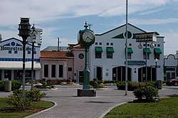
- Homestead Historic Downtown District
- Homestead Seaboard Air Line Railway Station
- Homestead Hospital Baptist Health South Florida
- Miami-Dade Public Library System – Homestead Branch
- Homestead Pavilion
- Homestead Championship Rodeo
- Homestead-Miami Speedway
- Homestead Sports Complex
- Homestead Air Reserve Base[30]
- Knaus Berry Farm
- Monkey Jungle
- Robert Is Here Fruit Stand and Farm
- Schnebly Redland's Winery
- Seminole Theatre
- South Dade Rail Trail
- Turkey Point Nuclear Generating Station
Notable people
- John Brown, NFL wide receiver for the Buffalo Bills
- James Burgess, NFL linebacker for the Cleveland Browns
- Alan Campbell, American Actor
- Dexter Lehtinen, former United States Attorney for the Southern District of Florida
- Scott Maddox, former mayor of Tallahassee, Florida
- Chrissy Metz, American actress and singer
- Lacey Sturm, former lead vocalist of American rock band Flyleaf
- Tommy Tate, American soul singer and songwriter
- Tom Vasel, podcaster, board game reviewer, and board game designer
- Herb Waters, NFL cornerback for the Green Bay Packers
- Jeff Zucker, current President of CNN Worldwide, former President of NBC Universal
Education
Homestead is within the Miami-Dade County Public Schools district.
Homestead and the region are zoned to the following elementary, middle and K-8 center schools:
- Air Base K-8 Center
- Avocado Elementary School
- Campbell Drive K-8 Center
- Campbell Drive Middle School
- Coconut Palm K-8 Academy
- Gateway Environmental K-8 Learning Center
- Homestead Middle School
- Irving & Beatrice Peskoe K-8 Center
- Laura C. Saunders Elementary School
- Leisure City K-8 Center
- Mandarin Lakes K-8 Academy
- Miami MacArthur South
- Neva King Cooper Education
- Redland Elementary School
- Redland Middle School
- Redondo Elementary School
- School for Advanced Studies-Homestead
- South Dade Middle School (Grades 4–8)
- West Homestead Elementary School
- William A. Chapman Elementary School
- MAST (Medical Academy for Science and Technology) @ Homestead
Most of Homestead is zoned to Homestead High School, while a northwest portion is zoned to South Dade High School, located outside the city limits in unincorporated Miami-Dade County.
Homestead is zoned to South Dade Educational Center.
Charter schools
Homestead also has the following charter schools:
- Keys Gate Charter School[31]
- Waterstone Charter School
- Advantage Academy of Math and Science at Waterstone
- Everglades Preparatory Academy
- ASPIRA South Youth Leadership Charter School
- Mavericks High of South Miami Dade County
- Somerset City Arts Conservatory
- Somerset Academy Charter Elementary School (South Homestead)
- Somerset Academy (Silver Palms)
- Somerset Oaks Academy
- Summerville Advantage Academy
- School for Integrated Academics and Technologies (SIATech)
- Miami Arts Charter School
Private schools
The Roman Catholic Archdiocese of Miami previously operated Sacred Heart School in Homestead.[32] It closed in 2009.[33]
Colleges and universities
Homestead is also home to Miami-Dade College Homestead Campus).
Parks and recreation
- Angelo Mistretta Park
- Audubon Park
- Biscado Park
- Blakey Park
- Camp Owaissa Bauer
- Ernestine Jackson Seymore Park
- Harris Field Park
- Homestead Air Reserve Park
- James Archer Smith Park
- JD Redd Park
- Leisure Park
- Leisure Lakes Park
- Losner Park
- Mayor Roscoe Warren Municipal Park
- Modello Wayside Park
- Musselwhite Park
- Naranja Lakes Park
- Palmland Park
- Phicol Williams Community Center
- Roby George Park
- Royal Colonial Park
- Seminole Wayside Park
- South Dade Park
- William F. Dickinson Community Center
- Wittkop Park
References
- "2016 U.S. Gazetteer Files". United States Census Bureau. Retrieved Jul 7, 2017.
- "Population and Housing Unit Estimates". Retrieved May 21, 2020.
- "U.S. Census website". United States Census Bureau. Retrieved 2008-01-31.
- "US Board on Geographic Names". United States Geological Survey. 2007-10-25. Retrieved 2008-01-31.
- Taylor, Jean (1985). Villages of South Dade. St. Petersburg, Fla: B. Kennedy. p. 157. LCCN 88132899. OCLC 18906834.
- "US Gazetteer files: 2010, 2000, and 1990". United States Census Bureau. 2011-02-12. Retrieved 2011-04-23.
- "F A Q". coralcastle.com. Archived from the original on 23 July 2005. Retrieved 20 March 2018.
- Weather History for Homestead retrieved August 6, 2006
- "NOWData - NOAA Online Weather Data". NOAA. Retrieved 28 January 2016.
- Kaye, Ken (August 25, 2015). "Hurricane Katrina hit South Florida 10 years ago today". Sun-Sentinel. Retrieved 2018-07-27.
- Clark, Cammy (October 25, 2005). "Auto track damaged by Wilma". Chicago Tribune. Retrieved 2018-07-27.
- Yanez, Luisa (November 8, 2005). "Dade Hit Hardest as Death Toll Reaches 31 Across the State". Miami Herald. pp. 1B.
- Jerry Iannelli (September 15, 2017). "Homestead Migrant Farm Workers Neglected After Irma Until Activists Raise Alarm". Miami New Times. Archived from the original on October 31, 2017. Retrieved December 2, 2017.
- "Census of Population and Housing". Census.gov. Retrieved June 4, 2015.
- American FactFinder, United States Census Bureau. "Homestead city, Florida – Census 2010:Florida – USATODAY.com –". USA Today. Retrieved January 12, 2012.
- "MLA Data Center Results of Homestead, FL". Modern Language Association. Archived from the original on 2007-09-30. Retrieved 2007-11-03.
- "Inside Homestead TV - Homestead, FL - Official Website". www.cityofhomestead.com. Retrieved 20 March 2018.
- "Homestead Correctional Institution." Florida Department of Corrections. Retrieved on May 15, 2010.
- "Dade Correctional Institution at Homestead."
- "Dade Correctional Institution." Florida Department of Corrections. Retrieved on May 15, 2010.
- "FACILITIES ON JUNE 30, 2003." Florida Department of Corrections. Retrieved on May 15, 2010.
- "Government releases video showing inside of Florida facility housing undocumented children". www.cbsnews.com. Retrieved 2019-01-04.
- "Post Office Location – HOMESTEAD Archived 2010-04-29 at the Wayback Machine." United States Postal Service. Retrieved on May 15, 2010.
- "Narrative Summary of Accidents Involving U.S. Nuclear Weapons 1950–1980" (PDF). United States Department of Defense. April 1981. Archived from the original (PDF) on 2010-05-28.
- City of Homestead: Homestead Trolley Bus Service Archived 2014-03-23 at the Wayback Machine (retrieved 3/23/14)
- The City of Homestead proudly introduces its National Parks Trolley (retrieved 3/21/14)
- The Miami Herald: Trolley service now lets visitors without cars to travel about Everglades and Biscayne National Parks, 1/4/14 (retrieved 3/21/14)
- National Park Service (ENP): Free Homestead National Parks Trolley to Launch at January 4 Celebration, 12/31/13 (retrieved 3/21/14)
- National Park Service (BNP): Celebration of the Launch of the Free Homestead Trolley to Biscayne National Park, 12/31/13 (retrieved 3/21/14)
- Reserve, Air Force. "Air Force Reserve". www.afreserve.com. Archived from the original on 17 October 2007. Retrieved 20 March 2018.
- "Keys Gate Charter School - A tuition-free public charter school". Keys Gate Charter School. Retrieved 20 March 2018.
- "Sacred Heart". Roman Catholic Archdiocese of Miami. 2004-02-17. Retrieved 2020-05-09.
300 SE 1st Drive [...] Homestead, Florida 33030
- Johnson, Akilah (2009-01-23). "Six schools to close as Archdiocese retrenches". South Florida Sun Sentinel. Retrieved 2020-05-10.
Surrounding areas
- Unincorporated Miami-Dade County, Leisure City, Homestead Base
- Unincorporated Miami-Dade County


- Unincorporated Miami-Dade County, Florida City


- Florida City


- Florida City, Unincorporated Miami-Dade County
External links
| Wikimedia Commons has media related to Homestead, Florida. |
Municipalities and communities of Miami-Dade County, Florida, United States | ||
|---|---|---|
| Cities | 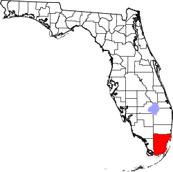 | |
| Towns | ||
| Villages | ||
| CDPs |
| |
| Unincorporated communities | ||
| Ghost town | ||
| Indian reservation | ||
| Footnotes | ‡This populated place also has portions in an adjacent county or counties | |
| Authority control |
|
|---|