Goulds, Florida
Goulds is a census-designated place (CDP) in Miami-Dade County, within the U.S. state of Florida. The area was originally populated as the result of a stop on the Florida East Coast Railroad. The railroad depot was located near the current Southwest 224th Street. The community was named after its operator, Lyman Gould, who cut trees for railroad ties. As of the 2009 census, the population stood at 10,103.[3]
Goulds, Florida | |
|---|---|
 Location in Miami-Dade County and the state of Florida | |
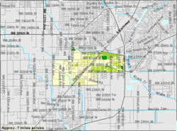 U.S. Census Bureau map showing CDP boundaries | |
| Coordinates: 25°33′39″N 80°23′0″W | |
| Country | |
| State | |
| County | Miami-Dade |
| Area | |
| • Total | 3 sq mi (7.7 km2) |
| • Land | 3 sq mi (7.7 km2) |
| • Water | 0 sq mi (0 km2) |
| Elevation | 10 ft (3 m) |
| Population (2010) | |
| • Total | 10,103 |
| • Density | 3,367.7/sq mi (1,300.3/km2) |
| Time zone | UTC-5 (Eastern (EST)) |
| • Summer (DST) | UTC-4 (EDT) |
| ZIP code | 33170 |
| Area code(s) | 305 |
| FIPS code | 12-26950[1] |
| GNIS feature ID | 0283239[2] |
Geography
Goulds is located at 25°33′39″N 80°23′0″W (25.560885, -80.383353).[4] According to the United States Census Bureau, the CDP has a total area of 3.0 square miles (7.8 km2), all of it land. Cauley Square Historic Village is notably located in Goulds.
History
The area that became Goulds was settled in 1900 by homesteaders. It received its name when the Florida East Coast Railway built a siding in 1903, operated by an employee of the railroad named Lyman Goulds. It was first known as Gould's Siding, and later shortened to Goulds. Many packing houses were built along Old Dixie Highway. Early on, Goulds had a reputation as a rough town, with several saloons serving itinerant field workers. Most of the packing houses were destroyed by a tornado in 1919, or the 1926 Miami Hurricane, but were rebuilt.[5] Today, Goulds is now a small community of African-Americans, sharing borders with the neighboring communities of South Miami Heights, Cutler Bay, Quail Heights, Redland, and Princeton.
Demographics
As of the census of 2009, there were 10,103 people in 2,987 households, including 2,391 families, in the CDP.[6] The population density was 2,514.5 people per square mile (972.2/km²). There were 2,367 housing units at an average density of 798.6/sq mi (308.8/km²). The racial makeup of the CDP was 39.1% White 55.2% African American, 0.2% Native American, 0.6% Asian, 0.01% Pacific Islander, 3.48% from other races, and 2.46% from two or more races. Hispanic or Latino of any race were 41.0% of the population.[6]
Of the 2,987 households 42.4% had children under the age of 18 living with them, 35.5% were married couples living together, 35.5% had a female householder with no husband present, and 20.0% were non-families.[6] 20.0% of households were one person and 15.9% were one person aged 65 or older. The average household size was 3.36 and the average family size was 3.71.[6]
The age distribution was 35.7% under the age of 20, 14.2% from 20 to 29, 13.6% from 30 to 39, 27.3% from 40 to 64, and 9.0% 65 or older.[6] The median age was 30 years old. The female population stood at 5,370 while for males at 4,733.[6]
The median household income was $33,200 and the median family income was $35,374.[7] Males had a median income of $26,822 versus $25,265 for females.[7] The per capita income for the CDP was $12,259. About 31.2% of families and 37.8% of the population were below the poverty line, including 47.9% of those under age 18 and 27.4% of those age 65 or over.[7]
As of 2009, speakers of English as a first language accounted for 54.4% of residents, while Spanish made up 41.8%, and other languages were at 3.6% of the population.[8]
Education
The Miami-Dade County Public Schools district serves Goulds.
References
- "U.S. Census website". United States Census Bureau. Retrieved 2008-01-31.
- "US Board on Geographic Names". United States Geological Survey. 2007-10-25. Retrieved 2008-01-31.
- "ACS Demographic and Housing Estimates". U.S. Census Bureau. Retrieved 2014-12-11.
- "US Gazetteer files: 2010, 2000, and 1990". United States Census Bureau. 2011-02-12. Retrieved 2011-04-23.
- Taylor, Jean (1985). Villages of South Dade. St. Petersburg, Fla: B. Kennedy. pp. 89–90. LCCN 88132899. OCLC 18906834.
- "2010 Demographic Profile Data". U.S. Census Bureau. Retrieved 2014-12-11.
- "Selected Economic Characteristics". U.S. Census Bureau. Retrieved 2014-12-11.
- "Selected Social Characteristics". U.S. Census Bureau. Retrieved 2014-12-11.
Municipalities and communities of Miami-Dade County, Florida, United States | ||
|---|---|---|
| Cities | 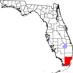 | |
| Towns | ||
| Villages | ||
| CDPs |
| |
| Unincorporated communities | ||
| Ghost town | ||
| Indian reservation | ||
| Footnotes | ‡This populated place also has portions in an adjacent county or counties | |