Hardee County, Florida
Hardee County is a county located in the U.S. state of Florida. As of the 2010 census, the population was 27,731.[1] Its county seat is Wauchula.[2]
Hardee County | |
|---|---|
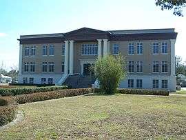
 Hardee County Courthouse | |
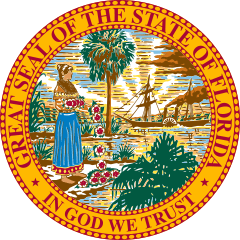
 Seal | |
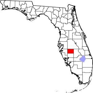 Location within the U.S. state of Florida | |
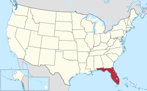 Florida's location within the U.S. | |
| Coordinates: 27°29′N 81°49′W | |
| Country | |
| State | |
| Founded | April 23, 1921 |
| Named for | Cary A. Hardee |
| Seat | Wauchula |
| Largest city | Wauchula |
| Area | |
| • Total | 638 sq mi (1,650 km2) |
| • Land | 638 sq mi (1,650 km2) |
| • Water | 0.6 sq mi (2 km2) 0.1%% |
| Population | |
| • Estimate (2019) | 26,937 |
| • Density | 43/sq mi (17/km2) |
| Time zone | UTC−5 (Eastern) |
| • Summer (DST) | UTC−4 (EDT) |
| Congressional district | 17th |
| Website | www |
Hardee County comprises the Wauchula, FL Micropolitan Statistical Area.
History
It was named for Cary A. Hardee, Governor of Florida from 1921 to 1925. Hardee County was created in 1921.
On August 13, 2004, Hurricane Charley went directly through Hardee County. Maximum sustained winds in downtown Wauchula were clocked at 149 mph (240 km/h) with higher gusts. Most buildings in the county sustained damage, and many were totally destroyed.
Geography
According to the U.S. Census Bureau, the county has a total area of 638 square miles (1,650 km2), of which 638 square miles (1,650 km2) is land and 0.6 square miles (1.6 km2) (%) is water.[3]
Hardee County is located in what is known as the "Bone Valley" which contains most of North America's phosphate deposits and a large portion of the world's deposits. Phosphate is mined in large open pit mines with massive settling ponds that contain many harmful byproducts of the mining process and its disposal and use are restricted thus leaving the settling ponds in place indefinitely and rendering the land unfit for agriculture The Mosaic company currently owns all mining land in Hardee County with around 10,000 acres near Fort Green and is proposing an expansion of around 27,000 acres in a new mine near Ona, FL. There is much controversy over the mining practice, the rezoning and conversion of agricultural land into open pit mines. Land is "reclaimed" after mining but leaves areas of mostly artificially created lakes and wetlands in addition to the slightly poisonous and radioactive settling ponds.[4] The proposed Ona mine[5] would surround Horse Creek, a tributary to the Peace River, thus threatening the very pristine and largely untouched natural waterway as well as the Peace River watershed.
Adjacent counties
- Polk County, Florida - north
- Highlands County, Florida - east
- DeSoto County, Florida - south
- Manatee County, Florida - west
- Hillsborough County, Florida - northwest
Demographics
| Historical population | |||
|---|---|---|---|
| Census | Pop. | %± | |
| 1930 | 10,348 | — | |
| 1940 | 10,158 | −1.8% | |
| 1950 | 10,073 | −0.8% | |
| 1960 | 12,370 | 22.8% | |
| 1970 | 14,889 | 20.4% | |
| 1980 | 19,379 | 30.2% | |
| 1990 | 19,499 | 0.6% | |
| 2000 | 26,938 | 38.2% | |
| 2010 | 27,731 | 2.9% | |
| Est. 2019 | 26,937 | [6] | −2.9% |
| U.S. Decennial Census[7] 1790-1960[8] 1900-1990[9] 1990-2000[10] 2010-2019[1] | |||
As of the census[11] of 2000, there were 26,938 people, 8,166 households, and 6,255 families residing in the county. The population density was 42 people per square mile (16/km²). There were 9,820 housing units at an average density of 15 per square mile (6/km²). The racial makeup of the county was 70.66% White, 8.33% Black or African American, 0.68% Native American, 0.30% Asian, 0.06% Pacific Islander, 17.99% from other races, and 1.97% from two or more races. 35.68% of the population were Hispanic or Latino of any race.
According to 2005 Census Estimates the county's population was 50.6% non-Hispanic white, 39.8% Latino, 9.0% African-American and 1.3% Native American. (source=https://www.webcitation.org/606449Yjg?url=http://quickfacts.census.gov/qfd/states/12/12049.html
In 2000 there were 8,166 households out of which 34.90% had children under the age of 18 living with them, 60.00% were married couples living together, 11.10% had a female householder with no husband present, and 23.40% were non-families. 18.00% of all households were made up of individuals and 9.40% had someone living alone who was 65 years of age or older. The average household size was 3.06 and the average family size was 3.40.
In the county, the population was spread out with 27.60% under the age of 18, 11.00% from 18 to 24, 28.30% from 25 to 44, 19.20% from 45 to 64, and 13.90% who were 65 years of age or older. The median age was 33 years. For every 100 females, there were 119.10 males. For every 100 females age 18 and over, there were 123.00 males.
The median income for a household in the county was $30,183, and the median income for a family was $32,487. Males had a median income of $23,793 versus $18,823 for females. The per capita income for the county was $12,445. About 17.00% of families and 24.60% of the population were below the poverty line, including 30.20% of those under age 18 and 16.10% of those age 65 or over.
Politics
| Year | Republican | Democratic | Other |
|---|---|---|---|
| 2016 | 68.57% 5,242 | 28.11% 2,149 | 3.32% 254 |
| 2012 | 64.83% 4,696 | 34.00% 2,463 | 1.17% 85 |
| 2008 | 64.00% 4,763 | 34.51% 2,568 | 1.49% 111 |
| 2004 | 69.65% 5,049 | 29.65% 2,149 | 0.70% 51 |
| 2000 | 60.38% 3,765 | 37.56% 2,342 | 2.07% 129 |
| 1996 | 47.18% 2,928 | 38.95% 2,417 | 13.87% 861 |
| 1992 | 45.08% 2,900 | 31.37% 2,018 | 23.55% 1,515 |
| 1988 | 66.96% 3,640 | 31.05% 1,688 | 1.99% 108 |
| 1984 | 72.06% 3,962 | 27.94% 1,536 | |
| 1980 | 48.82% 2,603 | 48.74% 2,599 | 2.44% 130 |
| 1976 | 42.86% 2,189 | 52.28% 2,670 | 4.86% 248 |
| 1972 | 84.57% 3,563 | 15.36% 647 | 0.07% 3 |
| 1968 | 28.34% 1,278 | 15.59% 703 | 56.08% 2,529 |
| 1964 | 54.88% 2,321 | 45.12% 1,908 | |
| 1960 | 52.96% 1,960 | 47.04% 1,741 | |
| 1956 | 45.67% 1,589 | 54.33% 1,890 | |
| 1952 | 46.55% 1,802 | 53.45% 2,069 | |
| 1948 | 24.12% 689 | 65.49% 1,871 | 10.40% 297 |
| 1944 | 24.72% 708 | 75.28% 2,156 | |
| 1940 | 21.33% 694 | 78.67% 2,559 | |
| 1936 | 28.27% 844 | 71.73% 2,142 | |
| 1932 | 18.55% 566 | 81.45% 2,485 | |
| 1928 | 70.06% 2,087 | 27.73% 826 | 2.22% 66 |
| 1924 | 22.66% 264 | 68.24% 795 | 9.10% 106 |
Libraries
Hardee County is part of the Heartland Library Cooperative which has 7 branches that serve Hardee County and some of the surrounding counties in the Florida Heartland, including Glades, Highlands, DeSoto, and Okeechobee.
- Avon Park
- DeSoto
- Glades
- Hardee
- Lake Placid
- Okeechobee
- Sebring
Communities
Cities
Town
Census-designated places
- Fort Green
- Fort Green Springs
- Gardner
- Lemon Grove
- Limestone
- Ona
Other unincorporated communities
- Crewsville
- Lake Dale
- Oak Grove
- Popash
- Sweetwater Ranch
- Village of Charlie Creek
Transportation
Airports
Education
The Hardee County School District has one high school, one junior high, and five elementary schools. Hardee Senior High and Hardee Junior High are in Wauchula. The elementary schools are Bowling Green, Hilltop, North Wauchula, Wauchula, and Zolfo Springs.
South Florida State College is a public college serving Hardee, Highlands and DeSoto Counties. Its Hardee campus is in Bowling Green.
References
- "State & County QuickFacts". United States Census Bureau. Retrieved February 14, 2014.
- "Find a County". National Association of Counties. Retrieved 2011-06-07.
- "US Gazetteer files: 2010, 2000, and 1990". United States Census Bureau. 2011-02-12. Retrieved 2011-04-23.
- "The Clock is Ticking on Florida's Mountains of Hazardous Phosphate Waste". Sarasota Magazine. Retrieved 2018-07-08.
- "Ona Project Overview | Mosaic in Hardee". Mosaic in Hardee. Retrieved 2018-07-08.
- "Population and Housing Unit Estimates". Retrieved May 21, 2020.
- "U.S. Decennial Census". United States Census Bureau. Retrieved June 14, 2014.
- "Historical Census Browser". University of Virginia Library. Retrieved June 14, 2014.
- "Population of Counties by Decennial Census: 1900 to 1990". United States Census Bureau. Retrieved June 14, 2014.
- "Census 2000 PHC-T-4. Ranking Tables for Counties: 1990 and 2000" (PDF). United States Census Bureau. Retrieved June 14, 2014.
- "U.S. Census website". United States Census Bureau. Retrieved 2011-05-14.
- Leip, David. "Dave Leip's Atlas of U.S. Presidential Elections". uselectionatlas.org. Retrieved 2018-06-15.
External links
| Wikimedia Commons has media related to Hardee County, Florida. |
Government links/constitutional offices
Special districts
Judicial branch
- Hardee County Clerk of Courts (Official Site)
- Public Defender, 10th Judicial Circuit of Florida serving Hardee, Highlands, and Polk counties
- Office of the State Attorney, 10th Judicial Circuit of Florida
- Circuit and County Court for the 10th Judicial Circuit of Florida
Museum and library resources
- Heartland Library Cooperative. Hardee County is part of the Heartland Library Cooperative
- The Herald-Advocate, the local newspaper for Hardee County, Florida fully and openly available in the Florida Digital Newspaper Library
Other resources
Places adjacent to Hardee County, Florida | ||||||||||
|---|---|---|---|---|---|---|---|---|---|---|
| ||||||||||
Municipalities and communities of Hardee County, Florida, United States | ||
|---|---|---|
| Cities | | |
| Town | ||
| CDPs | ||
| Unincorporated communities | ||
| Ghost town | ||
| Authority control |
|
|---|