Sunset, Florida
Sunset is a census-designated place (CDP) and affluent neighborhood in Miami-Dade County, Florida, United States. The population was 16,389 at the 2010 census. The zip-codes serving Sunset are 33173, 33183, and 33193.
Sunset, Florida | |
|---|---|
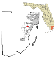 Location in Miami-Dade County and the state of Florida | |
 U.S. Census Bureau map showing CDP boundaries | |
| Coordinates: 25°42′21″N 80°21′23″W | |
| Country | |
| State | |
| County | Miami-Dade |
| Area | |
| • Total | 3.6 sq mi (9.2 km2) |
| • Land | 3.6 sq mi (9.2 km2) |
| • Water | 0 sq mi (0 km2) |
| Elevation | 7 ft (2 m) |
| Population (2000) | |
| • Total | 17,150 |
| • Density | 4,763.9/sq mi (1,864.1/km2) |
| Time zone | UTC-5 (Eastern (EST)) |
| • Summer (DST) | UTC-4 (EDT) |
| ZIP codes | 33173, 33183, 33193 |
| Area code(s) | 305 |
| FIPS code | 12-69812[1] |
| GNIS feature ID | 1867214[2] |
Geography
Sunset is located at 25°42′21″N 80°21′23″W (25.705820, -80.356296).[3] It is bordered by the neighborhoods of Kendale Lakes, Glenvar Heights, Westwood Lakes, Kendall, and Olympia Heights.
According to the United States Census Bureau, the CDP has a total area of 3.6 square miles (9.2 km²), of which, 3.6 square miles (9.2 km²) of it is land and 0.28% is water.
Demographics
| Historical population | |||
|---|---|---|---|
| Census | Pop. | %± | |
| 1980 | 13,531 | — | |
| 1990 | 15,810 | 16.8% | |
| 2000 | 17,150 | 8.5% | |
| 2010 | 16,389 | −4.4% | |
| source:[4] | |||
At the 2000 census there were 17,150 people, 5,488 households, and 4,505 families in the CDP. The population density was 4,820.6 people per square mile (1,860.0/km²). There were 5,608 housing units at an average density of 1,576.3/sq mi (608.2/km²). The racial makeup of the CDP was 91.24% White (26.1% Non-Hispanic White,)[5] 1.51% African American, 0.11% Native American, 2.45% Asian, 2.49% from other races, and 2.20% from two or more races. Hispanic or Latino of any race were 69.69%.[1]
Of the 5,488 households 36.8% had children under the age of 18 living with them, 63.9% were married couples living together, 14.0% had a female householder with no husband present, and 17.9% were non-families. 12.7% of households were one person and 4.3% were one person aged 65 or older. The average household size was 3.10 and the average family size was 3.38.
The age distribution was 23.3% under the age of 18, 9.0% from 18 to 24, 29.6% from 25 to 44, 24.6% from 45 to 64, and 13.5% 65 or older. The median age was 38 years. For every 100 females, there were 91.4 males. For every 100 females age 18 and over, there were 86.4 males.
The median household income was $58,903 and the median family income was $66,422. Males had a median income of $39,893 versus $31,234 for females. The per capita income for the CDP was $23,735. About 5.4% of families and 7.1% of the population were below the poverty line, including 6.9% of those under age 18 and 8.2% of those age 65 or over.
As of 2000, speakers of Spanish as a first language accounted for 73.75% of residents, while English made up 24.03%, and French was the mother tongue of 0.63% of the population.[6]
Transportation
The Don Shula Expressway Toll Road and Snapper Creek Expressway run through the southeast corner of Sunset.
Education
Miami-Dade County Public Schools operates public schools.
References
- "U.S. Census website". United States Census Bureau. Retrieved 2008-01-31.
- "US Board on Geographic Names". United States Geological Survey. 2007-10-25. Retrieved 2008-01-31.
- "US Gazetteer files: 2010, 2000, and 1990". United States Census Bureau. 2011-02-12. Retrieved 2011-04-23.
- "CENSUS OF POPULATION AND HOUSING (1790-2000)". U.S. Census Bureau. Retrieved 2010-07-17.
- "Demographics of Sunset, FL". MuniNetGuide.com. Retrieved 2007-11-09.
- "MLA Data Center Results of Sunset, FL". Modern Language Association. Retrieved 2007-11-09.
Municipalities and communities of Miami-Dade County, Florida, United States | ||
|---|---|---|
| Cities | 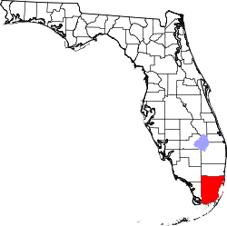 | |
| Towns | ||
| Villages | ||
| CDPs |
| |
| Unincorporated communities | ||
| Ghost town | ||
| Indian reservation | ||
| Footnotes | ‡This populated place also has portions in an adjacent county or counties | |