Cutler Bay, Florida
Cutler Bay is an incorporated town in Miami-Dade County, Florida established in 2005, with a population of approximately 43,718 as of 2019.[3]
Cutler Bay, Florida | |
|---|---|
| Town of Cutler Bay | |
 Seal | |
| Motto(s): "An Excellent Place to Live, Work and Play."[1] | |
 Location in Miami-Dade County and the state of Florida | |
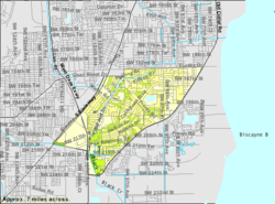 U.S. Census Bureau map showing town boundaries | |
| Coordinates: 25°34′57″N 80°20′48″W | |
| Country | |
| State | |
| County | |
| Incorporated | November 9, 2005 |
| Government | |
| • Type | Council-Manager |
| • Mayor | Tim Meerbott |
| • Vice Mayor | Sue Ellen Loyzelle |
| • Councilmembers | Robert "B.J." Duncan, Michael P. Callahan, and Roger Coriat |
| • Town Manager | Rafael G. Casals |
| • Town Clerk | Debra E. Eastman |
| Area | |
| • Total | 10.29 sq mi (26.64 km2) |
| • Land | 9.89 sq mi (25.61 km2) |
| • Water | 0.40 sq mi (1.03 km2) |
| Population (2010) | |
| • Total | 40,286 |
| • Estimate (2019)[3] | 43,718 |
| • Density | 4,537.98/sq mi (1,752.19/km2) |
| Time zone | UTC-5 (EST) |
| • Summer (DST) | UTC-4 (EDT) |
| Zip Codes | 33157, 33189 |
| Area code(s) | 305, 786 |
| FIPS code | 12-15968 |
| Website | http://www.cutlerbay-fl.gov/ |
The borders were established as running from SW 184th Street (Eureka Dr) east of US 1 to the coast, and north of Black Point Marina, at 25°34′50″N 80°20′48″W.[4] The town's boundaries include the northeast section of Biscayne National Park,[5] areas formerly known as Cutler Ridge[4] to the west, as well as the neighborhood and former CDP of Lakes by the Bay[6] to the east.
In August 1992, Hurricane Andrew made landfall near the area and caused extensive destruction. Lakes by the Bay was one of the areas of Miami most affected by Hurricane Andrew, and most homes and businesses in the area were completely destroyed. The area has since been rebuilt.
Geography
Cutler Bay is located just west of Biscayne Bay at 25°34′58″N 80°20′48″W.[7]
According to the United States Census Bureau, the CDP had a total area of 4.9 square miles (13 km2). 4.8 square miles (12 km2) of it is land and 0.1 square miles (0.26 km2) of it (2.26%) is water. The total square miles is ten.
Cutler Ridge, an ancient coral formation, stretches from south Miami, where it rises approximately 22 feet, through the Cutler Bay area, at a height of 14 feet, to Homestead, Florida, where it is about 8 feet.[8] Cutler Ridge has been incorporated into the hurricane emergency plans for the area as lands east of the ridge are subject to storm surge, but areas west of the ridge would generally be protected.[8]
Due to Cutler Bay's position in a flat, low-lying coastal wetland area on Biscayne Bay, the area is prone to flooding. During the rainy season, Cutler Bay's many canals, channels, and lakes are frequently full of water, and the groundwater table also is full and close to the surface. Flood hazards include rainfall from tropical storms, hurricanes, and other heavy rain events.[9]
Media
The Town of Cutler Bay is served by the Miami market for local radio and television. The town has its own newspaper, Cutler Bay News,[10] which is published bi-weekly and is part of Miami Community Newspapers. Additionally, The Miami Herald provides news coverage for the town under the Cutler Bay heading of its "Miami-Dade Communities" section.
History
The town was named after Dr. William Cutler of Massachusetts, who visited the area north of the town around 1880 and encouraged others to settle in what became the pioneer town of Cutler.[11]
The Charles Deering Estate, located in nearby Palmetto Bay, contains the Cutler Fossil Site where mammoths, sabre-toothed tigers and California condors are among the many fossil records. The park holds archeological evidence of Native American habitation of the land 10,000 years ago.[12] Tequesta burial mounds are also found there.[12] The area called Cutler Ridge had been called the "Hunting Ground" by some of the earliest Caucasian settlers in the area, circa 1825.[13]
In the early 1900s the Florida East Coast Railway was extended south to Cutler, which was located near what is now the Charles Deering Estate. Cutler then served as the place where people settling in the undeveloped Homestead, Florida area went to get their supplies.[4]
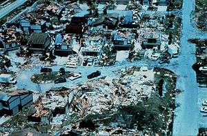
In 1992, Hurricane Andrew made landfall near Cutler Ridge.[14] The storm left the area in "almost total destruction".[15] The dense vegetation near the shore and the dense subdivision development of the area are thought to have been factors which mitigated the extent of areas impacted by flood damage caused by Andrew.[16] However, nearly every building suffered major damage from the wind, and the damage in Florida was estimated at $25 billion, the most expensive natural disaster in US history to that point.[17]
In May 2002, the Cutler Bay Steering Committee company met to discuss the formation of a municipal advisory committee, where the committee would advise on the incorporation of the Cutler Ridge area into the city of Cutler Ridge.[18] The decision to incorporate was spurred in part by the efforts to recover from Hurricane Andrew.[19] The proposed incorporation boundaries included Southwest 184th Street on the north and Southwest 216th and 224th streets on the south.[18] In addition, the west boundary would include the Turnpike, U.S. 1 and Southwest 112th Avenue and Biscayne Bay would serve as the east boundary.[18]
In April 2005, the Charter committee members looked at over a dozen names for the city, ranging from "Pine Ridge" and "Cutler Bay" to just "Cutler".[20] They reduced the choices to "Cutler Ridge" and "Old Cutler Bay".[20] In November 2005, voters approved the charter and chose the name "Cutler Bay" for the county's 35th municipality, over "Cutler Ridge" by a vote of 1,920 to 1,403.[21] In the months following the name change, many of those born and raised in the area that had been known as Cutler Ridge since the 1870s refused to accept the new name.[22]
Demographics
| Historical population | |||
|---|---|---|---|
| Census | Pop. | %± | |
| 1960 | 7,005 | — | |
| 1970 | 17,441 | 149.0% | |
| 1980 | 20,886 | 19.8% | |
| 1990 | 21,268 | 1.8% | |
| 2000 | 24,781 | 16.5% | |
| 2010 | 40,286 | 62.6% | |
| Est. 2019 | 43,718 | [3] | 8.5% |
| U.S. Decennial Census[23] 2018 Estimate[24] | |||
| Cutler Bay Demographics | |||
|---|---|---|---|
| 2010 Census | Cutler Bay | Miami-Dade County | Florida |
| Total population | 40,286 | 2,496,435 | 18,801,310 |
| Population, percent change, 2000 to 2010 | +62.6% | +10.8% | +17.6% |
| Population density | 4,096.3/sq mi | 1,315.5/sq mi | 350.6/sq mi |
| White or Caucasian (including White Hispanic) | 77.3% | 73.8% | 75.0% |
| (Non-Hispanic White or Caucasian) | 28.5% | 15.4% | 57.9% |
| Black or African-American | 14.2% | 18.9% | 16.0% |
| Hispanic or Latino (of any race) | 54.5% | 65.0% | 22.5% |
| Asian | 2.3% | 1.5% | 2.4% |
| Native American or Native Alaskan | 0.2% | 0.2% | 0.4% |
| Pacific Islander or Native Hawaiian | 0.1% | 0.0% | 0.1% |
| Two or more races (multiracial) | 3.2% | 2.4% | 2.5% |
| Some other race | 2.7% | 3.2% | 3.6% |
As of 2015, there were 13,935 households out of which 7.8% were vacant.[25] In 2010, the population distribution was: 6.8% under 5 years old, 25.8% under the age of 18, and 10.6% 65 years of age or older. Females were 51.7% of the population. The median income for a household was $61.370. The per capita income for the town was $25,193. About 10.5% of the population were below the poverty line.[26]
As of 2000, speakers of English as a first language accounted for 58.89%, while Spanish made up 38.18%, and French Creole comprised 1.31% of the population.[27] According to the latest American Community Survey of 2008-2012 conducted by the US Census Bureau, the percentage of people who spoke English as their main language was of 44.1%, while Spanish speakers were at 50.4% of the population, and other languages accounted for 5.5%.[28]
As of 2000, Cutler Bay had the thirty-fifth highest percentage of Cuban residents in the US, with 13.37% of the populace.[29] It had the 151st highest percentage of Puerto Rican residents in the US, at 6.56% of the town's population,[30] and the eighty-second highest percentage of Colombian residents in the US, at 1.90% of its population.[31] It also had the ninety-fifth most Dominicans in the US, at 1.66% (tied with Palisades Park, New Jersey,)[32] while it had the twenty-ninth highest percentage of Nicaraguans, at 1.43% of all residents.[33]
Government and infrastructure
Cutler Bay is governed by a five-member Town Council and operates under a Council-Manager form of government. Three Council Members are elected to represent specific residential areas (Seats 1, 2 & 3) and must reside in their respective area. The Mayor and the Vice Mayor may reside anywhere in the Town. Town Council elections are non-partisan. As the legislative body of the Town, the Town Council determines policy, adopts the annual budget and makes laws.[34] The Miami-Dade Police Department operates the South District Station in Cutler Bay.[35]
In January 2006, Cutler Bay elected former Florida state legislator John F. Cosgrove as its first mayor. Mayor Cosgrove died on April 19, 2006, while vacationing in Zimbabwe.[36] Vice Mayor Paul Vrooman assumed the position of Mayor. In November 2010, Edward P. MacDougall was elected Mayor from Vice Mayor. Prior to incorporation Edward MacDougall chaired the municipal charter committee which set the Town's charter. In November 2014, Peggy Bell, who was one of the original Council Members when Cutler Bay was incorporated, was elected Mayor and served as Mayor until she reached her term limits in November 2018.[37][38] Elected in November 2018, the current office of Mayor is held by former Council member Tim Meerbott.[39]
The community bought an office building, Cutler Bay Town Center, circa 2010; in 2020 the building was about 33% occupied. The city government planned to make money by leasing space in the building, but buyers did not materialize. In 2010 it traded the building for 16 acres (6.5 ha) of land, where it plans to build municipal offices.[40]
Education
Primary and secondary schools
Miami-Dade County Public Schools operates public schools.
Elementary schools in the town limits include:
- Bel-Aire Elementary School
- Gulfstream Elementary School
- Dr. Edward L. Whigham Elementary School
- Whispering Pines Elementary School
Cutler Bay Middle School and Cutler Bay Senior High School are in Cutler Bay. Prior to 2012 Cutler Bay had two middle schools (Centennial and Cutler Ridge), and Miami Southridge High School was the zoned school. Centennial was converted into a high school and Cutler Ridge became the sole middle school of Cutler Bay.[41]
The charter school Mater Academy Cutler Bay is in Cutler Bay.[42]
The Roman Catholic Archdiocese of Miami operates Catholic schools. Our Lady of the Holy Rosary-St. Richard School, a K-8 school, is in Cutler Bay.[43][44]
Colleges and universities
- College of Business and Technology (Cutler Bay Campus)
Surrounding areas
- Palmetto Bay
- West Perrine


- Unincorporated Miami-Dade County, South Miami Heights, Goulds


- Goulds, Princeton


- Unincorporated Miami-Dade County, Lakes by the Bay
References
- "Cutler Bay, Florida". City of North Lauderdale (Website, May 12, 2007-February 21, 2015) via Wayback Machine. Archived from the original on February 21, 2015. Retrieved March 3, 2019.
- "2018 U.S. Gazetteer Files". United States Census Bureau. Retrieved Jul 19, 2019.
- "Population and Housing Unit Estimates". Retrieved May 21, 2020.
- Bramson, Seth; Jensen, Bob (2013). Homestead, Florida: From Railroad Boom to Sonic Boom. The History Press. pp. 135, 15. ISBN 9781626191877. Retrieved 25 January 2014.
- "Maps Biscayne National Park (U.S. National Park Service)". National Park Service (NPS.gov). National Park Service, U.S. Department of the Interior. Retrieved 28 June 2017.
- "Cutler Bay Aerial Board - Revised". Town of Cutler Bay. Retrieved 25 June 2017.
- "US Gazetteer files: 2010, 2000, and 1990". United States Census Bureau. 2011-02-12. Retrieved 2011-04-23.
- Wilson, Jennifer J.; Travers, James P. (January 1997). Hurricane Andrew: South Florida and Louisiana, August 23-26, 1992: Natural Disaster Survey Report. DIANE Publishing. pp. 54–. ISBN 9780788130731. Retrieved 26 January 2014.
- "Cutler Bay, FL - Flood Awareness". Town of Cutler Bay. Retrieved 25 June 2017.
- Cutler Bay News
- Cutler Bay History
- Hammer, Roger L. (2005-05-15). A Falconguide to Everglades National Park and the Surrounding Area: A Guide to Exploring the Great Outdoors. Globe Pequot Press. pp. 154–. ISBN 9780762734320. Retrieved 27 January 2014.
- Blank, Joan (1996). Key Biscayne: A History of Miami's Tropical Island and the Cape Florida Lighthouse. Pineapple Press Inc. pp. 72–. ISBN 9781561640966. Retrieved 27 January 2014.
- Green, Jen (2005-01-01). Hurricane Andrew. Gareth Stevens Pub. pp. 4–. ISBN 9780836844979. Retrieved 26 January 2014.
- Jr., Eugene F. Provenzo (1995-07-01). Hurricane Andrew, the Public Schools, and the Rebuilding of Community. SUNY Press. pp. 86–. ISBN 9780791424827. Retrieved 26 January 2014.
- Agency, Federal Emergency Management. Hurricane Andrew in Florida Building Performance Observations, Recommendations, and Technical Guidance. FEMA. pp. 38–. Retrieved 14 June 2015.
- Roberson, William G. (2014-09-29). Block by Block: The Challenges of Urban Operations. Maroon Ebooks. pp. 408–. Retrieved 14 June 2015.
- "Ridge Group To Discuss Forming Mac", Miami Herald, p. 4, May 5, 2002, retrieved January 25, 2014
- Kemp, Roger L. (2013-02-21). Town and Gown Relations: A Handbook of Best Practices. McFarland. pp. 67–. ISBN 9781476601700. Retrieved 14 June 2015.
- "Around Miami-Dade County", Miami Herald, p. 3B, April 13, 2005, retrieved January 25, 2014
- "Cutler Ridge morphed into Cutler Bay on Tuesday", Miami Herald, p. B3, November 9, 2005, retrieved January 25, 2014
- Yudy Pineiro (November 10, 2005), "Cutler Bay: 'Ridge Rats' Scoff At Name Change", Miami Herald, p. B3, retrieved January 25, 2014
- "U.S. Decennial Census". Census.gov. Retrieved April 19, 2014.
- "Population Estimates". United States Census Bureau. Retrieved June 8, 2018.
- Bureau, U.S. Census. "U.S. Census website". United States Census Bureau. Retrieved 28 June 2017.
- "Cutler Bay (town), Florida". U.S. Census Bureau. Archived from the original on 25 June 2012. Retrieved 6 June 2012.
- "MLA Data Center Results of Cutler Bay (Cutler Ridge,) FL". Epodunk.com. Retrieved 2007-11-03.
- "U.S. Census website". United States Census Bureau. Retrieved 2008-01-31.
- "Ancestry Map of Cuban Communities". Epodunk.com. Retrieved 2007-11-03.
- "Ancestry Map of Puerto Rican Communities". Epodunk.com. Archived from the original on 2006-07-15. Retrieved 2007-11-03.
- "Ancestry Map of Colombian Communities". Epodunk.com. Retrieved 2007-11-03.
- "Ancestry Map of Dominican Communities". Epodunk.com. Archived from the original on 2010-10-17. Retrieved 2007-11-03.
- "Ancestry Map of Nicaraguan Communities". Epodunk.com. Archived from the original on 2010-10-17. Retrieved 2007-11-03.
- "Cutler Bay, FL : Town Council". cutlerbay-fl.gov. Retrieved 2019-02-19.
- "South District Station Archived 2010-01-27 at the Wayback Machine." Miami-Dade Police Department. Retrieved on March 12, 2010.
- Past National President John Cosgrove enters Chapter Eternal at 56
- "Cutler Bay has a new mayor and councilman after Tuesday's runoff election". miamiherald. Retrieved 2019-02-19.
- "Bell wins mayor's office in Cutler Bay". miamiherald. Retrieved 2019-02-19.
- "Archived copy" (PDF). Archived from the original (PDF) on 2015-01-18. Retrieved 2015-01-18.CS1 maint: archived copy as title (link)
- Lefever, Bailey (2020-01-27). "Officials hope land swap will help Cutler Bay preserve green space, build new town hall". Miami Herald. Retrieved 2020-05-07.
- Stein, Perry (2011-09-23). "Cutler Bay On Track for New High School". Miami Herald.
- https://www.materacademybay.com/
- "Zoning Map". Cutler Bay, Florida. Retrieved 2020-05-06.
- "Home". Our Lady of the Holy Rosary-St. Richard. Retrieved 2020-05-06.
Further reading
- U.S. Census Bureau maps:
- Census 2000 Block Map: Cutler Ridge CDP - Pages 1, 2, 3, and 4.
- 1990 U.S. Census Map of Miami-Dade County, with Cutler Ridge on Page 5
External links
| Wikimedia Commons has media related to Cutler Bay, Florida. |
Municipalities and communities of Miami-Dade County, Florida, United States | ||
|---|---|---|
| Cities | 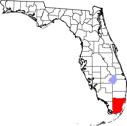 | |
| Towns | ||
| Villages | ||
| CDPs |
| |
| Unincorporated communities | ||
| Ghost town | ||
| Indian reservation | ||
| Footnotes | ‡This populated place also has portions in an adjacent county or counties | |
| Authority control |
|---|