Palm Springs, Florida
Palm Springs is a village in Palm Beach County, Florida, United States, situated between Greenacres, Lake Clarke Shores, Lake Worth, and West Palm Beach. As of the 2010 United States Census, had a population of 18,928.[6] It is a village within the Miami metropolitan area, which was home to an estimated 6,012,331 people as of 2015.
Palm Springs, Florida | |
|---|---|
Village | |
| Village of Palm Springs | |
| Motto(s): "Garden Spot of Palm Beach County" | |
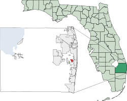 Location of Palm Springs, Florida | |
 Palm Springs, Florida Location of Palm Springs, Florida | |
| Coordinates: 26°38′09″N 080°05′46″W | |
| Country | |
| State | |
| County | |
| Incorporated | July 4, 1957 |
| Government | |
| • Type | Council-Manager |
| • Mayor | Beverly "Bev" Smith |
| • Vice Mayor | Doug Gunther |
| • Councilmembers | Patricia "Patti" Waller, Gary M. Ready, and Mayor Pro Tem Joni Brinkman |
| • Village Manager | Richard J. Reade |
| • Village Clerk | Kimberly M. Wynn |
| Area | |
| • Total | 4.06 sq mi (10.52 km2) |
| • Land | 4.01 sq mi (10.40 km2) |
| • Water | 0.05 sq mi (0.12 km2) |
| Elevation | 13 ft (4 m) |
| Population (2010) | |
| • Total | 18,928 |
| • Estimate (2019)[2] | 25,216 |
| • Density | 5,990.29/sq mi (2,312.84/km2) |
| Time zone | UTC−05:00 (Eastern (EST)) |
| • Summer (DST) | UTC−04:00 (EDT) |
| ZIP Codes | 33406, 33415, 33461[3] |
| Area code(s) | 561 |
| FIPS code | 12-54450[4] |
| GNIS feature ID | 0293892[5] |
| Website | https://www.vpsfl.org/ |
It was the 30th incorporated municipality in Palm Beach County, with the establishment charter approved by the Florida Legislature on July 4, 1957. The village name was likely derived from the resort city of Palm Springs, California.
Geography
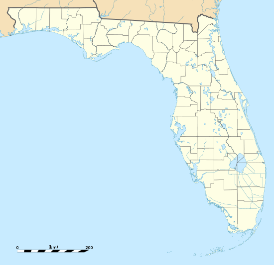
Palm Springs is located at 26°38′09″N 080°05′46″W (26.6359, -080.0936) in east-central Palm Beach County. The village is situated adjacent to Greenacres, Lake Clarke Shores, Lake Worth, and West Palm Beach. According to the United States Census Bureau, Palm Springs has a total area of 3.5 square miles (9.1 km2), of which 1.6 square miles (4.1 km2) is land and 0.1 square miles (0.26 km2) (3.01%) is water.
Government
The village council is composed of five elected officials, a mayor and four members. Of the four other persons on the village council, one serves as vice mayor and another as mayor pro tempore. Twice a month, the village council meets in the Village Hall at 226 Cypress Lane. They are elected on a non-partisan basis for two-year terms. The mayor and the members of district 1 and 3 are elected in odd-numbered years, while districts 2 and 4 are up for election during even-numbered years. Both elections occurred on the first Tuesday in March, followed by a runoff on the fourth Tuesday of March, if a no candidate receives a majority of the vote. The five members of the village council are:[7]
- Mayor Beverly "Bev" Smith
- District 1: Doug Gunther (Vice Mayor)
- District 2: Patti Waller
- District 3: Gary M. Ready
- District 4: Joni Brinkman (Mayor Pro Tem)
Other local officials include Village Manager Richard Reade, Village Attorney Glen Torcivia, and Village Clerk Kimberly M. Wynn.[7][8]
On the state level, Palm Springs is represented by Dave Silvers (D) of the Florida House of Representatives's 87th district and Lori Berman (D) of the Florida Senate's 31st district. Nationally, the village is served by Lois Frankel (D) of Florida's 21st congressional district and U.S. Senators Rick Scott (R) and Marco Rubio (R).
History
In 1957, Florida House of Representatives member Ralph Blank, Jr. of Palm Beach County introduced legislation to establish the village of Palm Springs. The bill passed unanimously and Palm Springs was chartered on July 4, 1957.[9] The village was likely named after the resort city of Palm Springs, California.[10] Originally, the townsite mainly consisted of about 700 acres (280 ha) farmland and a large dairy barn. By August 1958, about 800 homes had been built. Four schools were built in the village and nearby between 1959 and 1970, beginning with Palm Springs Elementary School in September 1959. Construction also began on a nearly 8,000 sq ft (740 m2) village hall, which opened in February 1960.[9]
The village's original boundaries remained unchanged for about four decades. In 1997, the village council adopted a plan for expanding Palm Springs. Under the plan, future annexation included all areas west to Military Trail from the present boundaries, between Lake Worth Road and north of Forest Hill Boulevard; and all areas east of the present boundaries to Florida Mango Road. The annexation plan was expected to increase the population of Palm Springs by another 10,000 residents, roughly twice the population in 1997. Also in the late 1990s, the village council began planning to renovate the original municipal complex, which was implemented after residents approved a bond referendum in 1999. A new village hall was opened in July 2003, while a newly renovated library and public safety building were complete in 2004 and 2005. The new complex also includes a water park, an additional playground, a pavilion, and tennis and volleyball courts.[9]
Demographics
| Historical population | |||
|---|---|---|---|
| Census | Pop. | %± | |
| 1960 | 2,503 | — | |
| 1970 | 4,340 | 73.4% | |
| 1980 | 8,166 | 88.2% | |
| 1990 | 9,763 | 19.6% | |
| 2000 | 11,699 | 19.8% | |
| 2010 | 18,928 | 61.8% | |
| Est. 2019 | 25,216 | [2] | 33.2% |
| U.S. Decennial Census[11] | |||
| Palm Springs Demographics | |||
|---|---|---|---|
| 2010 Census | Palm Springs | Palm Beach County | Florida |
| Total population | 18,928 | 1,320,134 | 18,801,310 |
| Population, percent change, 2000 to 2010 | +61.8% | +16.7% | +17.6% |
| Population density | 5,731.3/sq mi | 670.2/sq mi | 350.6/sq mi |
| White or Caucasian (including White Hispanic) | 72.7% | 73.5% | 75.0% |
| (Non-Hispanic White or Caucasian) | 35.4% | 60.1% | 57.9% |
| Black or African-American | 12.1% | 17.3% | 16.0% |
| Hispanic or Latino (of any race) | 50.6% | 19.0% | 22.5% |
| Asian | 1.7% | 2.4% | 2.4% |
| Native American or Native Alaskan | 0.5% | 0.5% | 0.4% |
| Pacific Islander or Native Hawaiian | 0.1% | 0.1% | 0.1% |
| Two or more races (Multiracial) | 3.9% | 2.3% | 2.5% |
| Some Other Race | 1.9% | 3.9% | 3.6% |
As of the census of 2010, there were 8,823 households, out of which 16.9% were vacant. In 2000, 26.7% had children under the age of 18 living with them, 39.7% were married couples living together, 13.5% had a female householder with no husband present, and 42.3% were non-families. 33.7% of all households were made up of individuals and 13.9% had someone living alone who was 65 years of age or older. The average household size was 2.27 and the average family size was 2.90. 8.1% of the population were same-sex married couples or partnerships.
In 2000, the population was spread out with 21.6% under the age of 18, 8.1% from 18 to 24, 32.9% from 25 to 44, 20.6% from 45 to 64, and 16.8% who were 65 years of age or older. The median age was 37 years. For every 100 females, there were 89.3 males. For every 100 females age 18 and over, there were 85.5 males.
In 2000, the median income for a household in the village was $36,026, and the median income for a family was $42,430. Males had a median income of $30,920 versus $26,106 for females. The per capita income for the village was $18,763. About 4.9% of families and 7.9% of the population were below the poverty line, including 7.2% of those under age 18 and 8.9% of those age 65 or over.
As of 2000, speakers of English as a first language accounted for 69.9% of all residents, while Spanish accounted for 24.1%, French Creole made up 2.0%, Italian was at 1.1%, German speakers were at 0.9%, French was spoken by 0.8%, Portuguese was at 0.6%, Polish at 0.4%, and Tagalog was a mother tongue for 0.3% of the population.[12]
As of 2000, Palm Springs had the fifty-first-highest percentage of Cuban residents in the US, with 7.6% of the city's populace.[13] It also had the fifty-second-highest percentage of Haitian residents, which was 2.9% (tied with four other areas, including Opa-locka,)[14] and the eighty-first-highest concentration of Colombian residents, which made up 1.9% of the population (tied with West Miami.)[15]
Economy
Businesses, concentrated on Congress Avenue and Tenth Avenue North, include several shopping centers, the largest of which are Greenwood and Palm Springs.[9]
Education
Primary and secondary schools
Palm Springs is served by the School District of Palm Beach County; the district has its headquarters in the Fulton-Holland Educational Services Center in Palm Springs.[16][17][18]
The village of Palm Springs is home to three public schools, while other nearby public schools serve students in Palm Springs. The public schools include:
- Berkshire Elementary School (located in West Palm Beach)[19]
- Clifford O. Taylor / Kirklane Elementary School[9]
- Palm Springs Elementary School[9]
- L. C. Swain Middle School (located in Greenacres)[20]
- Palm Springs Community Middle School[9]
- John I. Leonard Community High School (located in Greenacres)[21]
St. Luke's Catholic School, a private school, is located in Palm Springs.[9] The village is also home to G-Star School of the Arts, which is a charter school and the largest high school for acting, animation, and film in the United States.[22]
Public libraries
The Palm Springs Public Library is located in the Village Government Complex.[23]
Transportation
State Road 802 (locally known as Lake Worth Road) passes east-west near the southern end of the village. Congress Avenue (designated as State Road 807) is a north-south oriented road close to the eastern boundary of Palm Springs. The far western edges of Palm Springs border Military Trail (designated as State Road 809). State Road 882 (locally known as Forest Hill Boulevard) moves west-east near the village's northern boundary. Two entrance and exit ramps for Interstate 95 are located along state roads 802 and 882, just outside the village limits. Several Palm Tran routes serve Palm Springs.
References
- "2016 U.S. Gazetteer Files". United States Census Bureau. Retrieved Jul 7, 2017.
- "Population and Housing Unit Estimates". Retrieved May 21, 2020.
- "Palm Springs, FL ZIP Codes". zipmap.net. Retrieved March 11, 2019.
- "U.S. Census website". United States Census Bureau. Retrieved 2008-01-31.
- "US Board on Geographic Names". United States Geological Survey. 2007-10-25. Retrieved 2008-01-31.
- "Community Facts - Find popular facts (population, income, etc.) and frequently requested data about your community". Retrieved 9 December 2015.
- "Village Council". The Village of Palm Springs. Retrieved November 22, 2014.
- Agenda – Village Council Meeting (PDF) (Report). The Village of Palm Springs. March 8, 2018. Retrieved March 19, 2018.
- "About Palm Springs". Palm Springs. Retrieved August 27, 2018.
- Eliot Kleinberg (September 16, 1987). "What's in a name? Lots of history if it's a town". The Palm Beach Post. p. 35. Retrieved July 21, 2018 – via Newspapers.com.

- "Census of Population and Housing". Census.gov. Retrieved June 4, 2015.
- "MLA Data Center Results for Palm Springs, Florida". Modern Language Association. Retrieved 2007-11-19.
- "Ancestry Map of Cuban Communities". Epodunk.com. Retrieved 2007-11-19.
- "Ancestry Map of Haitian Communities". Epodunk.com. Archived from the original on 2012-12-11. Retrieved 2007-11-19.
- "Ancestry Map of Colombian Communities". Epodunk.com. Retrieved 2007-11-19.
- "Welcome to the School District of Palm Beach County." School District of Palm Beach County. Retrieved on March 28, 2010. "Fulton-Holland Educational Services Center 3300 Forest Hill Boulevard West Palm Beach, FL 33406."
- "2006 Districting Map Archived 2009-08-15 at the Wayback Machine." Palm Springs. Retrieved on March 29, 2010.
- "Districting Map Archived 2009-08-15 at the Wayback Machine." Palm Springs. Retrieved on March 29, 2010.
- "Elementary School Attendance Boundaries SY2018–19" (PDF). School District of Palm Beach County. 2018. Retrieved August 23, 2018.
- "Middle School Attendance Boundaries SY2018–19" (PDF). School District of Palm Beach County. 2018. Retrieved August 23, 2018.
- "High School Attendance Boundaries SY2018–19" (PDF). School District of Palm Beach County. 2018. Retrieved August 23, 2018.
- "What makes G-Star so different from the high school my child is zoned to attend next year?". G-Star School of the Arts. Retrieved August 27, 2018.
- "Hours and Location." Palm Springs Public Library. Retrieved on March 29, 2010.
External links
- Village of Palm Springs
- Palm Springs Public Library
- U.S. Geological Survey Geographic Names Information System: Palm Springs (populated place)
- U.S. Geological Survey Geographic Names Information System: Village of Palm Springs (civil)
Municipalities and communities of Palm Beach County, Florida, United States | ||
|---|---|---|
| Cities | 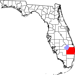 | |
| Towns | ||
| Villages | ||
| CDPs | ||
| Former CDPs |
| |
| Unincorporated communities | ||
| Ghost towns | ||