Bay Harbor Islands, Florida
Bay Harbor Islands is a town in Miami-Dade County, Florida, United States. The population was 5,628 at the 2010 census. It is separated from the mainland by Biscayne Bay, over which the land masses are connected via the Broad Causeway. On the mainland side, Bay Harbor Islands is bordered by the city of North Miami, while to the east it borders the villages of Bal Harbour and Surfside. To the south lies the exclusive village of Indian Creek. Bay Harbor Islands is about 20 minutes' driving distance away from Miami International Airport, and it is situated between the larger cities of Aventura and Miami Beach.
Town of Bay Harbor Islands Bay Harbor Islands | |
|---|---|
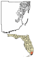 Location of Bay Harbor Islands in Miami-Dade County, Florida. | |
 U.S. Census Bureau map showing the Town's boundaries | |
| Coordinates: 25°53′15″N 80°8′9″W | |
| Country | |
| State | |
| County | |
| Incorporated | April 28, 1947 |
| Government | |
| • Type | Council-Manager |
| • Mayor | Stephanie Bruder |
| • Vice Mayor | Joshua D. Fuller |
| • Councilmembers | Jordan W. Leonard, Robert Yaffe, Isaac Salver, Elizabeth Tricoche, and Kelly Reid |
| • Interim Town Manager | Marlene Marante Siegel |
| • Interim Town Clerk | Alba Chang |
| Area | |
| • Total | 0.42 sq mi (1.09 km2) |
| • Land | 0.40 sq mi (1.03 km2) |
| • Water | 0.03 sq mi (0.06 km2) |
| Elevation | 7 ft (2 m) |
| Population (2010) | |
| • Total | 5,628 |
| • Estimate (2018)[2] | 5,964 |
| • Density | 15,060.61/sq mi (5,809.47/km2) |
| Time zone | UTC-5 (Eastern (EST)) |
| • Summer (DST) | UTC-4 (EDT) |
| ZIP code | 33154 |
| Area code(s) | 305, 786 |
| FIPS code | 12-03975[3] |
| GNIS feature ID | 0278201[4] |
| Website | http://www.bayharborislands-fl.gov |
History
Bay Harbor Islands was founded by Shepard Broad on April 28, 1947. It consists of two islands: originally known as Broadview and Bay Harbor, now referred to as, respectively, the West and East Islands. The West Island features single family homes, while the East Island contains the business district, a K-8 school, and multi-family housing.
Geography
Bay Harbor Islands is located at 25°53′15″N 80°8′9″W (25.887522, -80.135739).[5]
According to the United States Census Bureau, the Town has a total area of 0.6 square miles (1.6 km2). 0.4 square miles (1.0 km2) of it is land and 0.2 square miles (0.52 km2) of it (39.34%) is water.
Surrounding areas
East Island architecture
Bay Harbor Islands east island features one of the largest concentrated collections of mid-century Miami Modern architecture of the 1940s and 1950s, including historic buildings designed by Morris Lapidus, Henry Hohauser, and Charles McKirahan.[6][7]
In 2014, the National Trust for Historic Preservation named Bay Harbor's East Island to its annual list of the "11 Most Endangered Historic Places" in America because the island's architecture was coming under pressure from development.[6] Two members of the Town Council responded to the listing by questioning the need to preserve the buildings.[7] Some residents, in turn, criticized council members for as lack of attention to historic preservation.[7]
Demographics
| Historical population | |||
|---|---|---|---|
| Census | Pop. | %± | |
| 1950 | 296 | — | |
| 1960 | 3,249 | 997.6% | |
| 1970 | 4,619 | 42.2% | |
| 1980 | 4,869 | 5.4% | |
| 1990 | 4,703 | −3.4% | |
| 2000 | 5,146 | 9.4% | |
| 2010 | 5,628 | 9.4% | |
| Est. 2018 | 5,964 | [2] | 6.0% |
| U.S. Decennial Census[8] | |||
| Bay Harbor Islands Demographics | |||
|---|---|---|---|
| 2010 Census | Bay Harbor Islands | Miami-Dade County | Florida |
| Total population | 5,628 | 2,496,435 | 18,801,310 |
| Population, percent change, 2000 to 2010 | +9.4% | +10.8% | +17.6% |
| Population density | 14,221.7/sq mi | 1,315.5/sq mi | 350.6/sq mi |
| White or Caucasian (including White Hispanic) | 91.5% | 73.8% | 75.0% |
| (Non-Hispanic White or Caucasian) | 49.1% | 15.4% | 57.9% |
| Black or African-American | 2.5% | 18.9% | 16.0% |
| Hispanic or Latino (of any race) | 46.3% | 65.0% | 22.5% |
| Asian | 1.2% | 1.5% | 2.4% |
| Native American or Native Alaskan | 0.2% | 0.2% | 0.4% |
| Pacific Islander or Native Hawaiian | 0.0% | 0.0% | 0.1% |
| Two or more races (Multiracial) | 2.3% | 2.4% | 2.5% |
| Some Other Race | 2.3% | 3.2% | 3.6% |
As of 2010, there were 3,199 households out of which 18.8% were vacant. In 2000, 20.3% had children under the age of 18 living with them, 35.6% were married couples living together, 10.7% had a female householder with no husband present, and 50.4% were non-families. 43.1% of all households were made up of individuals and 18.6% had someone living alone who was 65 years of age or older. The average household size was 1.97 and the average family size was 2.71.
In 2000, the Town's population was spread out with 18.0% under the age of 18, 5.0% from 18 to 24, 32.1% from 25 to 44, 21.7% from 45 to 64, and 23.3% who were 65 years of age or older. The median age was 42 years. For every 100 females, there were 80.1 males. For every 100 females age 18 and over, there were 75.3 males.
In 2000, the median income for a household in the Town was $38,514, and the median income for a family was $43,939. Males had a median income of $38,750 versus $31,044 for females. The per capita income for the Town was $29,261. About 8.0% of families and 13.1% of the population were below the poverty line, including 20.7% of those under age 18 and 6.8% of those age 65 or over.
As of 2000, speakers of English as a first language constituted 52.05% of the population, while Spanish accounted for 43.90%, Portuguese 1.65%, Hebrew 1.30%, and French 1.10%.[9]
As of 2000, Bay Harbor Islands had the twenty-second-highest percentage of Colombian residents in the US, with 4.72% of the US populace.[10] It had the fifty-first-highest percentage of Cuban residents in the US, at 8.51% of the Town's population.[11] It also had the ninth-most Peruvians in the US, at 3.11%,[12] while it had the twentieth-highest percentage of Romanians, at 1.10% of all residents (tied with Hollywood, Florida and many other areas in the US.)[13] Bay Harbor Islands' Turkish community had the seventh-highest percentage of residents, which was at 1.20% (tying with five other US areas, such as Highland Beach.)[14] It's also home to the seventeenth-highest percentage of Venezuelan residents in the US, at 1.15% of the population.[15]
Notable people
- Christian Fittipaldi race car driver
- Lesley Visser, American sportscaster and the first female NFL analyst on TV
- Néstor Torres, jazz flautist
- Stanley G. Tate, former mayor
- Garrett Wittels, baseball player
In popular culture
In the Dexter (season 2), the discovery of Dexter's victims' remains inspires the press to dub the serial killer the "Bay Harbor Butcher".
Parts of the video for the song La Tortura by Colombian recording artist, Shakira, featuring Spanish recording artist Alejandro Sanz, was recorded at the historic Coral Sea Towers building in Bay Harbor Islands.
References
- "2018 U.S. Gazetteer Files". United States Census Bureau. Retrieved Jul 19, 2019.
- "Population and Housing Unit Estimates". Retrieved June 4, 2019.
- "U.S. Census website". United States Census Bureau. Retrieved 2008-01-31.
- "US Board on Geographic Names". United States Geological Survey. 2007-10-25. Retrieved 2008-01-31.
- "US Gazetteer files: 2010, 2000, and 1990". United States Census Bureau. 2011-02-12. Retrieved 2011-04-23.
- 11 Most Endangered Historic Places: Bay Harbor’s East Island , National Trust for Historic Preservation.
- Jackie Salo, Bay Harbor Islands council reacts to criticism, Miami Herald, August 15, 2014.
- "Census of Population and Housing". Census.gov. Retrieved June 4, 2015.
- "MLA's Data Center Results of Bay Harbor Islands, FL". Modern Language Association. Archived from the original on October 12, 2007. Retrieved 2007-10-28.
- "Ancestry Map of Colomblian Communities". Epodunk.com. Archived from the original on 11 October 2007. Retrieved 2007-10-28.
- "Ancestry Map of Cuban Communities". Epodunk.com. Archived from the original on 7 November 2007. Retrieved 2007-10-28.
- "Ancestry Map of Peruvian Communities". Epodunk.com. Archived from the original on 11 October 2007. Retrieved 2007-10-28.
- "Ancestry Map of Romanian Communities". Epodunk.com. Archived from the original on 7 November 2007. Retrieved 2007-10-28.
- "Ancestry Map of Turkish Communities". Epodunk.com. Archived from the original on 7 November 2007. Retrieved 2007-10-28.
- "Ancestry Map of Venezuelan Communities". Epodunk.com. Archived from the original on 11 October 2007. Retrieved 2007-10-28.
External links
- Town of Bay Harbor Islands official site
Municipalities and communities of Miami-Dade County, Florida, United States | ||
|---|---|---|
| Cities | 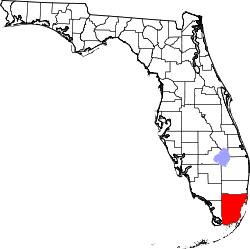 | |
| Towns | ||
| Villages | ||
| CDPs |
| |
| Unincorporated communities | ||
| Ghost town | ||
| Indian reservation | ||
| Footnotes | ‡This populated place also has portions in an adjacent county or counties | |
| Authority control |
|
|---|