South Miami Heights, Florida
South Miami Heights is a census-designated place (CDP), originally known as Eureka, in Miami-Dade County, within the U.S. state of Florida. The population was 35,696 as of the 2010 census.
South Miami Heights, Florida | |
|---|---|
 South Miami Heights, 1972 | |
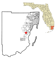 Location in Miami-Dade County and the state of Florida | |
 U.S. Census Bureau map showing CDP boundaries | |
| Coordinates: 25°35′20″N 80°23′7″W | |
| Country | |
| State | |
| County | Miami-Dade |
| Area | |
| • Total | 4.9 sq mi (12.8 km2) |
| • Land | 4.9 sq mi (12.8 km2) |
| • Water | 0 sq mi (0 km2) |
| Elevation | 10 ft (3 m) |
| Population (2010) | |
| • Total | 35,696 |
| • Density | 6,841.2/sq mi (2,618.9/km2) |
| Time zone | UTC-5 (Eastern (EST)) |
| • Summer (DST) | UTC-4 (EDT) |
| ZIP code | 33157, 33177, 33189 |
| Area code(s) | 305 |
| FIPS code | 12-67575[1] |
| GNIS feature ID | 0291396[2] |
Geography
South Miami Heights is located at 25°35′20″N 80°23′7″W (25.588784, -80.385209).[3]
According to the United States Census Bureau, the CDP has a total area of 4.9 square miles (12.8 km²), all of it land.
Demographics
| Historical population | |||
|---|---|---|---|
| Census | Pop. | %± | |
| 1970 | 10,395 | — | |
| 1980 | 23,559 | 126.6% | |
| 1990 | 30,030 | 27.5% | |
| 2000 | 33,522 | 11.6% | |
| 2010 | 35,696 | 6.5% | |
| source:[4] | |||
As of the census in 2010, there were 35,696 people, 10,706 households, and 8,358 families living in the CDP.[1] The population density was 6,800.4 people per square mile (2,625.3/km²). There were 10,364 housing units at an average density of 2,102.5/sq mi (811.7/km²). The racial makeup of the CDP was 67.2% White (11.2% Non-Hispanic White,) 24.3% African American, 0.28% Native American, 1.5% Asian, 0.02% Pacific Islander, 6.85% from other races, and 5.23% from two or more races.[5] Hispanic or Latino of any race were 68.0% of the population.[5]
Of the 10,706 households 55.3% had children under the age of 18 living with them, 52.4% were married couples living together.[6] Hispanic or Latino of any race were 68.0% of the population.[5] The average household size was 3.30 and the average family size was 3.63.[6]
The age distribution was 27.6% under the age of 19, 14.0% from 20 to 29, 12.8% from 30 to 39, 32.6% from 40 to 64, and 12.9% 65 or older. The median age was 37 years. For every 100 females, there were 93.3 males. For every 100 females age 18 and over, there were 88.4 males.[5]
The median family income in the CDP was $45,334. Males had a median income of $32,054 versus $27,254 for females. The per capita income for the CDP was $16,229. About 18.5% of families and 18.9% of the population were below the poverty line, including 27.0% of those under age 18 and 26.2% of those age 65 or over.[7]
As of 2010, speakers of Spanish as a first language accounted for 46.0% of residents, while English made up 35.7%, French was at 0.94%, and French Creole was the mother tongue of 0.81% of the population.[8]
References
- "U.S. Census website". United States Census Bureau. Retrieved 2008-01-31.
- "US Board on Geographic Names". United States Geological Survey. 2007-10-25. Retrieved 2008-01-31.
- "US Gazetteer files: 2010, 2000, and 1990". United States Census Bureau. 2011-02-12. Retrieved 2011-04-23.
- "CENSUS OF POPULATION AND HOUSING (1790-2000)". U.S. Census Bureau. Retrieved 2010-07-17.
- "General Housing and Population Characteristics". U.S. Census Bureau. Retrieved 2014-12-14.
- "Household and Families". U.S. Census Bureau. Retrieved 2014-12-14.
- "Income". U.S. Census Bureau. Retrieved 2014-12-14.
- "Language Spoken at Home". U.S. Census Bureau. Retrieved 2014-12-14.
Municipalities and communities of Miami-Dade County, Florida, United States | ||
|---|---|---|
| Cities | 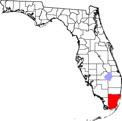 | |
| Towns | ||
| Villages | ||
| CDPs |
| |
| Unincorporated communities | ||
| Ghost town | ||
| Indian reservation | ||
| Footnotes | ‡This populated place also has portions in an adjacent county or counties | |