Hawthorne, California
Hawthorne is a city in southwestern Los Angeles County, California. As of the 2010 US census, it had a population of 84,293. In 2019, the population was estimated at 86,068.[7]
Hawthorne, California | |
|---|---|
City | |
 Seal | |
| Motto(s): "City of Good Neighbors" | |
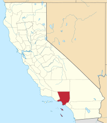
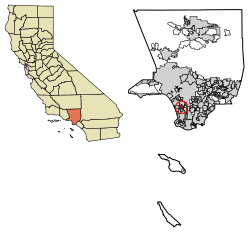 Location of Hawthorne in Los Angeles County, California. | |
 Hawthorne Location in the United States  Hawthorne Hawthorne (California)  Hawthorne Hawthorne (the United States) | |
| Coordinates: 33°55′2″N 118°20′55″W | |
| Country | |
| State | |
| County | |
| Incorporated | July 12, 1922[1] |
| Government | |
| • Type | City council |
| • Mayor | Alex Vargas
City Council
|
| • Interim City Manager | Arnold Shadbehr |
| Area | |
| • Total | 6.09 sq mi (15.78 km2) |
| • Land | 6.08 sq mi (15.76 km2) |
| • Water | 0.01 sq mi (0.03 km2) 0.18% |
| Elevation | 72 ft (22 m) |
| Population | |
| • Total | 84,293 |
| • Estimate (2019)[7] | 86,068 |
| • Rank | 93rd in California |
| • Density | 14,471.64/sq mi (5,587.45/km2) |
| Time zone | UTC−8 (Pacific Time Zone) |
| • Summer (DST) | UTC−7 (PDT) |
| ZIP Codes | 90250 and 90251[8] |
| Area codes | 310/424,[9] 213/323 |
| FIPS code | 06-32548 |
| GNIS feature IDs | 1652717, 2410720 |
| Website | cityofhawthorne.org |
History
The city was founded in 1905 as the "Hawthorne Improvement Company" by B.L. Harding and H.D. Lombard. Harding's daughter shared her birthday—the 4th of July, American Independence Day—with New England author Nathaniel Hawthorne, and a decision was made to name the city after him.[10]
Hawthorne was once a "whites only" settlement, commonly called a sundown town.[11] During the 1930s, signs warned African-Americans to be out of Hawthorne by sundown.[12]
Geography
According to the United States Census Bureau, the city has an area of 6.1 square miles (16 km2), over 99% of it land.
To the north of Hawthorne is the unincorporated community of Lennox and the city of Inglewood. To the east is the unincorporated community of Athens and the city of Gardena. To the south is the unincorporated community of El Camino Village, and the cities of Lawndale and Redondo Beach. Manhattan Beach is at the southwest corner of Hawthorne. To the west is the city of El Segundo, and the Los Angeles neighborhood of Westchester is to the northwest of Hawthorne. The unincorporated community of Del Aire is surrounded on three sides by the city of Hawthorne.
The Century Freeway (Glenn Anderson Freeway, I-105) runs along the northern boundary of Hawthorne, with the LACMTA Green Line light rail line running down the center of the Century Freeway. The San Diego Freeway (I-405) runs along the western boundary of Hawthorne. Major east–west streets in Hawthorne include Rosecrans Avenue, El Segundo Boulevard, and Imperial Highway. Major north–south streets include Aviation Boulevard, Inglewood Avenue, Hawthorne Boulevard, Prairie Avenue, Crenshaw Boulevard, and Van Ness Avenue.
Hawthorne is five miles (8 km) from the Los Angeles International Airport.[13]
Hawthorne comprises ZIP codes 90250 and 90251. It is in the 310 area code, except for a small portion of northeastern Hawthorne, which is located in the 323 area code.
Climate
| Hawthorne, California | ||||||||||||||||||||||||||||||||||||||||||||||||||||||||||||
|---|---|---|---|---|---|---|---|---|---|---|---|---|---|---|---|---|---|---|---|---|---|---|---|---|---|---|---|---|---|---|---|---|---|---|---|---|---|---|---|---|---|---|---|---|---|---|---|---|---|---|---|---|---|---|---|---|---|---|---|---|
| Climate chart (explanation) | ||||||||||||||||||||||||||||||||||||||||||||||||||||||||||||
| ||||||||||||||||||||||||||||||||||||||||||||||||||||||||||||
| ||||||||||||||||||||||||||||||||||||||||||||||||||||||||||||
Hawthorne, like the rest of the Los Angeles basin, has a Mediterranean climate:
- On average, the warmest month is August.
- The highest recorded temperature was 111 °F (44 °C) in 1961.
- On average, the coolest month is January.
- The lowest recorded temperature was 15 °F (−9 °C) in 1963.
- Most rainfall occurs during winter and spring.
Hawthorne has a Mediterranean climate or dry-summer subtropical (Köppen climate classification Csb on the coast, Csa inland), enjoying plenty of sunshine throughout the year, with an average of 263 sunshine days and only 35 days with measurable precipitation annually.[14]
The period of April through November is warm to hot and dry with average high temperatures of 71–79 °F (22–26 °C) and lows of 50–62 °F (10–17 °C). Due to the moderating effect of the ocean, temperatures are cooler than more inland areas of Los Angeles, where temperatures frequently exceed 90 °F (32 °C) and occasionally reach 100 °F (38 °C).
The Los Angeles area is also subject to the phenomena typical of a microclimate. As such, the temperatures can vary as much as 18 °F (10 °C) between inland areas and the coast, with a temperature gradient of over one degree per mile (1.6 km) from the coast inland. California has also a weather phenomenon called "June Gloom or May Grey", which sometimes brings overcast or foggy skies in the morning at the coast, but usually gives way to sunny skies by noon, during late spring and early summer.
The Los Angeles region averages 15 inches (385 mm) of precipitation annually, which mainly occurs during the winter and spring (November through April) with generally light rain showers, but sometimes as heavy rainfall and thunderstorms. On November 6, 1966, the first ever documented tornado touched down within city limits. It caused significant damage, ran for about one-half mile, from 132nd Street and Ramona Avenue to 140th Street and Ramona Avenue. Snowfall is extremely rare but not impossible in the city basin.
Demographics
| Historical population | |||
|---|---|---|---|
| Census | Pop. | %± | |
| 1930 | 6,596 | — | |
| 1940 | 8,263 | 25.3% | |
| 1950 | 16,316 | 97.5% | |
| 1960 | 33,035 | 102.5% | |
| 1970 | 53,304 | 61.4% | |
| 1980 | 56,437 | 5.9% | |
| 1990 | 71,349 | 26.4% | |
| 2000 | 84,112 | 17.9% | |
| 2010 | 84,293 | 0.2% | |
| Est. 2019 | 86,068 | [7] | 2.1% |
| U.S. Decennial Census[15] | |||
2010
At the 2010 census Hawthorne had a population of 84,293. The population density was 13,835.7 people per square mile (5,342.0/km²). The racial makeup of Hawthorne was 27,678 (32.8%) White (10.3% Non-Hispanic White),[6] 23,385 (27.7%) African American, 565 (0.7%) Native American, 5,642 (6.7%) Asian, 974 (1.2%) Pacific Islander, 22,127 (26.3%) from other races, and 3,922 (4.7%) from two or more races. Hispanic or Latino of any race were 44,572 persons (52.9%).[16]
The census reported that 83,754 people (99.4% of the population) lived in households, 208 (0.2%) lived in non-institutionalized group quarters, and 331 (0.4%) were institutionalized.
There were 28,486 households, 12,330 (43.3%) had children under the age of 18 living in them, 10,833 (38.0%) were opposite-sex married couples living together, 6,369 (22.4%) had a female householder with no husband present, 2,357 (8.3%) had a male householder with no wife present. There were 2,309 (8.1%) unmarried opposite-sex partnerships, and 191 (0.7%) same-sex married couples or partnerships. Of the households, 7,125 (25.0%) were one person and 1,430 (5.0%) had someone living alone who was 65 or older. The average household size was 2.94. There were 19,559 families (68.7% of households); the average family size was 3.54.
The age distribution was 23,157 people (27.5%) under the age of 18, 9,487 people (11.3%) aged 18 to 24, 27,035 people (32.1%) aged 25 to 44, 18,395 people (21.8%) aged 45 to 64, and 6,219 people (7.4%) who were 65 or older. The median age was 31.5 years. For every 100 females, there were 93.2 males. For every 100 females age 18 and over, there were 89.6 males.
There were 29,869 housing units at an average density of 4,902.7 per square mile, of the occupied units 7,623 (26.8%) were owner-occupied and 20,863 (73.2%) were rented.The homeowner vacancy rate was 1.5%; the rental vacancy rate was 4.6%. 25,869 people (30.7% of the population) lived in owner-occupied housing units and 57,885 people (68.7%) lived in rental housing units.
During 2009–2013, Hawthorne had a median household income of $44,649, with 19.2% of the population living below the federal poverty line.[6]
2000
As of the census[17] of 2000, there were 84,112 people in 28,536 households, including 19,775 families, in the city. The population density was 13,879.4 inhabitants per square mile (5,359.0/km²). There were 29,629 housing units at an average density of 4,889.1 per square mile (1,887.8/km²). The racial makeup of the city was 29.27% White, 39.02% Black or African American, 0.75% Native American, 7.73% Asian, 0.86% Pacific Islander, 24.16% from other races, and 5.22% from two or more races. 44.3% of the population were Hispanic or Latino of any race.
There were 28,536 households, 43.7% included children under the age of 18, 38.6% were married couples living together, 23.5% had a female householder with no husband present, and 30.7% were non-families. Of all households 24.5% were one person and 4.5% were one person aged 65 or older. The average household size was 2.93 and the average family size was 3.50.
The age distribution was 31.7% under the age of 18, 11.3% from 18 to 24, 34.9% from 25 to 44, 16.1% from 45 to 64, and 6.1% 65 or older. The median age was 29 years. For every 100 females, there were 92.6 males. For every 100 females age 18 and over, there were 87.3 males.
The median household income was $31,887 and the median family income was $35,149. Males had a median income of $29,481 versus $27,427 for females. The per capita income for the city was $15,022. About 18.4% of families and 20.3% of the population were below the poverty line, including 25.6% of those under age 18 and 9.0% of those age 65 or over.
Economy
The following businesses are located in Hawthorne:
- The Boring Company
- Century Media Records, independent rock label
- Hawthorne Plaza, a regional shopping center, now closed
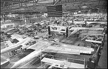
- Northrop Corporation, founded in 1939 and headquartered in Hawthorne, became a major manufacturer of aircraft during World War II, as well as a major subcontractor to other aircraft companies. Jack Northrop developed his famous flying wings, which ultimately led to the B-2 stealth bomber. Northrop also produced the P-61 Black Widow fighter in its Hawthorne plant, which was on the south side of Northrop Field (present-day Hawthorne Airport). The facility was, for some time, used as an aircraft plant, producing fuselage sections for Boeing 747s and 787s.[19] The building is currently used as the headquarters and main factory of SpaceX.[20]
- OSI Systems, electronics manufacturer
- SpaceX has its headquarters at the Hawthorne Municipal Airport.
- Tesla Motors has its design center at the Hawthorne Municipal Airport.
Previously in Hawthorne:
- Mattel (formerly), toy manufacturer; originally started in Hawthorne in 1945 and moved to their current facility in El Segundo, California by 1991.[21]
Government
Municipal government
Hawthorne has an elected city council composed of a mayor elected every four years and four city council members elected on staggering four year terms.
| OFFICE | OFFICE HOLDER | TERM ENDS |
|---|---|---|
| Mayor | Alex Vargas | December 2020 |
| Mayor Pro Tem | Olivia Valentine | December 2022 |
| Councilmember | Mike Talleda | December 2020 |
| Councilmember | Alex Monteiro | December 2022 |
| Councilmember | Haidar Awad | December 2020 |
| OFFICE | OFFICE HOLDER | TERM ENDS |
|---|---|---|
| City Treasurer | L. David Patterson | December 2022 |
| City Clerk | Paul Jimenez | December 2022 |
According to the city's most recent "Comprehensive Annual Financial Report," its various funds had $126.1 million in revenues, $113.2 million in expenditures, $220.2 million in total assets, $152.7 million in total liabilities, and $29.6 million in cash and investments.[24] The structure of the management and coordination of city services is:[25] The interim city manager is Arnold Shadbehr.[3]
State and federal representation
In the California State Legislature, Hawthorne is in the 35th Senate District, represented by Democrat Steven Bradford, and in the 62nd Assembly District, represented by Democrat Autumn Burke.[26]
In the United States House of Representatives, Hawthorne is in California's 43rd congressional district, represented by Democrat Maxine Waters.[27]
Education
Primary and secondary schools
Hawthorne is served by multiple school districts.[28]
- Hawthorne High School
- Leuzinger High School (Lawndale, California)
- Lawndale High School (Lawndale, California)
- Hawthorne School District
- Wiseburn School District
- Juan Cabrillo Elementary School (Kindergarten-2nd grade)
- Peter Burnett Elementary School (3rd-5th grade)
- Richard Henry Dana Middle School (6th-8th grade)
- Da Vinci Schools (9th-12th grade)
- Franklin D. Roosevelt-Kit Carson Elementary School (Alondra Park)[29]
- Will Rogers Middle School (Lawndale)[30]
- Lennox School District
- Elementary schools with boundaries coinciding include: Buford, Jefferson, and Moffett[31]
- All district residents are zoned to Lennox Middle School (grades 7-8)
- Cimarron Elementary School (Hawthorne)
- Clay Middle School (Unincorporated area)
- Washington Preparatory High School (Unincorporated area)
In addition Los Angeles County Office of Education operates Southwest Day (5th-12th grade).
Hawthorne Math and Science Academy is a charter high school in Hawthorne associated with the Hawthorne School District.[32]
Private schools
- Saint Joseph's Parish School (Catholic)
- Trinity Lutheran School
- Al Huda Islamic School
Colleges and universities
- Los Angeles Southwest College (in an unincorporated area in Los Angeles County)
- El Camino College
Media
The Hawthorne Press Tribune is the community newspaper for the City of Hawthorne.[33]
Infrastructure
The Los Angeles County Department of Health Services operates the Curtis Tucker Health Center in Inglewood, serving Hawthorne.[34]
The United States Postal Service Hawthorne Post Office is located at 12700 Inglewood Avenue.[35]
Notable people
- Each original member of the Beach Boys grew up in Hawthorne—Brian, Dennis and Carl Wilson, Mike Love, and Al Jardine—as well as early member David Marks. The Wilsons' childhood home is commemorated by the Beach Boys Historic Landmark.[36][37][38]
- Carl Boenish, base jumper
- NFL players Curtis Conway,[39][40] Jason Simmons,[41] and Dennis Northcutt have all resided in Hawthorne.
- Fred Dryer, defensive end in the NFL, actor and producer, was born in Hawthorne in 1946[42]
- Tyler, the Creator of OFWGKTA grew up in Hawthorne.
- Domo Genesis of OFWGKTA was born in Hawthorne.
- Singer-songwriter Cuco grew up and currently resides in Hawthorne.[43]
- NEA chairman Dana Gioia was born and reared in Hawthorne.
- Jazz critic and music historian Ted Gioia was born and raised in Hawthorne and graduated from Hawthorne High.[44][45]
- Tracy Jones, former Major League Baseball player, and 700 WLW radio host was born in Hawthorne.
- Rapper Kurupt lived in Hawthorne after moving from Philadelphia.[46]
- Scott Laidlaw Running back for the Dallas Cowboys and the New York Giants of the NFL was born in Hawthorne, grew up in Hawthorne, and went to Hawthorne High School.
- Michael Marsh, Olympic gold medalist, attended Hawthorne High[47]
- Mike McDermott, former member of the Maryland House of Delegates was born in Hawthorne.[48]
- Actress Marilyn Monroe lived in the city from infancy until she was 6.[49][50]
- Singer Chris Montez grew up in Hawthorne.[51]
- Jack Northrop, founded and managed Northrop Corporation, which was headquartered in Hawthorne. (see Economy section above)[52]
- Actor Butch Patrick of TV's The Munsters also lived in Hawthorne for a short time.[36]
- Musician Emitt Rhodes, lives in Hawthorne.
- Major League Baseball pitcher (New York Mets and Houston Astros) and Cy Young Award winner Mike Scott grew up in Hawthorne and graduated from Hawthorne High School in 1973.[53]
- Film and stage actress Betta St. John was born in Hawthorne.
- Sports figure Jim Thorpe resided in Hawthorne during part of his life, and there is a park named after him.[54][55]
- Russell Westbrook of the Houston Rockets grew up in Hawthorne.[56][57]
- Dorell Wright of the Portland Trail Blazers grew up in Hawthorne.
- Gyasi Zardes of the Columbus Crew SC grew up in Hawthorne.
References
- "California Cities by Incorporation Date". California Association of Local Agency Formation Commissions. Archived from the original (Word) on October 17, 2013. Retrieved August 25, 2014.
- "City Council". City of Hawthorne. Retrieved June 10, 2017.
- "City Manager's Office". City of Hawthorne. Retrieved June 10, 2017.
- "2016 U.S. Gazetteer Files". United States Census Bureau. Retrieved July 19, 2017.
- "Hawthorne". Geographic Names Information System. United States Geological Survey. Retrieved October 11, 2014.
- "Hawthorne (city) QuickFacts". United States Census Bureau. Archived from the original on February 7, 2016. Retrieved November 16, 2016.
- "Population and Housing Unit Estimates". Retrieved May 21, 2020.
- "USPS – ZIP Code Lookup – Find a ZIP+ 4 Code By City Results". Retrieved January 18, 2007.
- "Number Administration System – NPA and City/Town Search Results". Archived from the original on September 29, 2007. Retrieved January 18, 2007.
- Dixon, Walt; Roberts, Jerry (2005). Hawthorne. Arcadia. p. 10. ISBN 9780738529714.
- KAPLAN, ERIN AUBRY (January 24, 2007). "Sun hasn't set on 'sundown towns'". Los Angeles Times. Retrieved December 2, 2017.
- Wexler, Laura (October 23, 2005). "Book Review: Darkness on the Edge of Town (A review of SUNDOWN TOWNS: A Hidden Dimension of American Racism by James W. Loewen)". The Washington Post. p. BW03. Retrieved December 2, 2017.
- "Google Maps". Google Maps. January 1, 1970. Retrieved June 25, 2012.
- "Weatherbase: Historical Weather for Los Angeles, California, United States of America". Weatherbase.com. Retrieved January 8, 2009.
- "Census of Population and Housing". Census.gov. Retrieved June 4, 2015.
- "2010 Census Interactive Population Search: CA - Hawthorne city". U.S. Census Bureau. Archived from the original on July 15, 2014. Retrieved July 12, 2014.
- "U.S. Census website". United States Census Bureau. Retrieved January 31, 2008.
- Parker, Dana T. Building Victory: Aircraft Manufacturing in the Los Angeles Area in World War II, p. 94, Cypress, CA 2013. ISBN 978-0-9897906-0-4.
- Parker, Dana T. Building Victory: Aircraft Manufacturing in the Los Angeles Area in World War II, pp. 93–106, Cypress, CA, 2013. ISBN 978-0-9897906-0-4.
- Belfiore, Michael (January 20, 2012). "Inside SpaceX: We Visit the Company's California Headquarters". Popular Mechanics. Retrieved January 7, 2019.
- "Mattel Toys to Move Its Headquarters to El Segundo Site". Los Angeles Times. September 20, 1989. Retrieved March 9, 2017.
- "Mayor Alex Vargas". HAWTHORNE CALIFORNIA. Retrieved July 14, 2018.
- "City Treasurer L. David Patterson". HAWTHORNE CALIFORNIA. Retrieved December 16, 2019.
- City of Hawthorne CAFR Archived December 14, 2010, at the Wayback Machine. Retrieved 2009-08-18.
- City of Hawthorne City Directory. Retrieved 2009-08-18. Archived February 21, 2014, at the Wayback Machine
- "Statewide Database". UC Regents. Archived from the original on February 1, 2015. Retrieved October 14, 2014.
- "California's 43rd Congressional District - Representatives & District Map". Civic Impulse, LLC. Retrieved October 6, 2014.
- "Zoning Map" (PDF). City of Hawthorne. Retrieved April 13, 2019. Compare this map to boundary maps issued by school districts.
- "School Site Locator" (Archive). Lawndale Elementary School District. Retrieved on January 2, 2017.
- "Elementary School & Middle School Boundaries as of September 2008." Lawndale Elementary School District. Retrieved on May 5, 2010.
- "Boundary map" (PDF). Lennox School District. Retrieved April 13, 2019.
- Hawthorne.k12.ca.us Archived October 21, 2006, at the Wayback Machine
- Hawthorne Press Tribune. Herald Publications. Retrieved on 2013-08-18.
- "Curtis Tucker Health Center." Los Angeles County Department of Health Services. Retrieved on March 18, 2010.
- "Post Office Location – HAWTHORNE." United States Postal Service. Retrieved on December 6, 2008.
- "The History of Hawthorne". Broowaha. Retrieved June 25, 2010.
- "City of Hawthorne, CA – Beach Boys". Cityofhawthorne.com. December 29, 2000. Archived from the original on July 8, 2011. Retrieved June 25, 2010.
- Selvin, Joel (May 31, 2005). "For the Beach Boys, fun, fun, fun began in humble Hawthorne". SF Gate. Retrieved October 17, 2016.
- Statistics. "Curtis Conway – No. 81 – WR – Southern California – Profile". Newyorkjets.com. Archived from the original on December 3, 2008. Retrieved June 25, 2010.
- "YouTube – Hawthorne vs. Leuzinger (11/4/1988)". Ca.youtube.com. Retrieved June 25, 2010.
- Jason Simmons News, Stats, Photos | Houston Texans. Sbnation.com. Retrieved on 2013-08-18.
- "Fred Dryer". IMDb.
- Roberts, Randall (November 10, 2017). "Cuco rising: How a teen romantic from Hawthorne is becoming the buzz of the biz". Los Angeles Times. Retrieved September 6, 2019.
- "Ted Gioia bio". www.tedgioia.com. Retrieved May 1, 2016.
- "Classmate Information". cougartown.com. Retrieved May 1, 2016.
- MTV, Kurupt.
- "Michael Marsh". www.usatf.org. Retrieved February 21, 2019.
- "MICHAEL A. McDERMOTT". HOUSE OF DELEGATES FORMER DELEGATES. Maryland State Archives. Retrieved January 20, 2015.
- "Tour Location: 459 E Rhode Island Street, Hawthorne, California". The Movieland Directory. Archived from the original on June 21, 2009. Retrieved June 25, 2010.
- "Marilyn Monroe: Encyclopedia II – Marilyn Monroe – Early life". Experiencefestival.com. Archived from the original on July 10, 2011. Retrieved June 25, 2010.
- "Welcome to the Official Chris Montez website". Chrismontez.com. Archived from the original on February 5, 2008. Retrieved June 25, 2010.
- Parker, Dana T. Building Victory: Aircraft Manufacturing in the Los Angeles Area in World War II, p. 93, Cypress, CA, 2013. ISBN 978-0-9897906-0-4.
- "Video". CNN. January 12, 1987. Retrieved May 4, 2010.
- "City of Hawthorne, CA – Thorpe". Cityofhawthorne.com. December 29, 2000. Archived from the original on December 28, 2008. Retrieved June 25, 2010.
- "City of Hawthorne, CA – Jim Thorpe". Cityofhawthorne.com. Archived from the original on May 2, 2011. Retrieved June 25, 2010.
- Fox Sports. Msn.foxsports.com. Retrieved on 2013-08-18.
- "Russell Westbrook - 2006-07 Men's Basketball Roster - UCLA". www.uclabruins.com.
Further reading
External links
| Wikimedia Commons has media related to Hawthorne, California. |
Places adjacent to Hawthorne, California | ||||||||||
|---|---|---|---|---|---|---|---|---|---|---|
| ||||||||||

| Authority control |
|
|---|