Pico Rivera, California
Pico Rivera is a city located in southeastern Los Angeles County, California, United States. The city is situated approximately 11 miles (18 km) southeast of downtown Los Angeles, on the eastern edge of the Los Angeles basin, and on the southern edge of the area known as the San Gabriel Valley. The ports of Long Beach and Los Angeles, as well as Los Angeles International Airport (LAX), are in close proximity.[10] The 2010 census reported that the city has a population of 62,942.
Pico Rivera, California | |
|---|---|
City | |
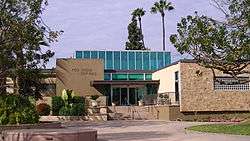 Pico Rivera City Hall | |
 Flag  Seal Logo | |
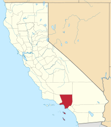
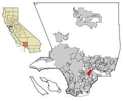 Location of Pico Rivera in Los Angeles County, California | |
 Pico Rivera, California Location in the United States | |
| Coordinates: 33°59′20″N 118°5′21″W | |
| Country | |
| State | |
| County | |
| Incorporated | January 29, 1958[1] |
| Government | |
| • Type | Council–manager[2] |
| • Mayor | Gustavo V. Camacho[3] |
| Area | |
| • Total | 8.88 sq mi (23.00 km2) |
| • Land | 8.30 sq mi (21.49 km2) |
| • Water | 0.59 sq mi (1.52 km2) 6.60% |
| Elevation | 164 ft (50 m) |
| Population | |
| • Total | 62,942 |
| • Estimate (2019)[7] | 62,027 |
| • Density | 7,670.56/sq mi (2,961.77/km2) |
| Time zone | UTC−8 (Pacific) |
| • Summer (DST) | UTC−7 (PDT) |
| ZIP Codes | 90660–90662[8] |
| Area code | 562[9] |
| FIPS code | 06-56924 |
| GNIS feature ID | 1652773 |
| Website | www |
History and culture
Pico Rivera was founded in 1958, from the merger of the long-standing unincorporated communities of Pico (named for Pío Pico, the last Mexican governor of California) and Rivera. Situated on a rich alluvial plain between the Rio Hondo and the San Gabriel River, the area was once predominantly agricultural; but, at the end of WWII, the fast rising demand for homes lured builders to the attractive terrain.[11] Since the 1950s, it has been both residential as well as industrial. It had a Ford Motor Company plant for many years: Los Angeles Assembly. Pico Rivera lies below the Whittier Narrows, making it one of the "Gateway Cities".[12]
In January 1958, 56 percent of the electorate voted for incorporation. They approved a Council-Manager form of government, and the name "Pico Rivera" was established for the new city. Five citizens were chosen from a slate of 24 candidates to serve as members of the first City Council; Pico Rivera officially became the 61st city in Los Angeles County.[11]
The north side of the city is home to the Pico Rivera Sports Arena, where concerts and other events are held.[13]
Parks and recreation
There are nine parks and playgrounds throughout the city, including Smith Park on Rosemead Boulevard, Rivera Park on Shade Lane, Pico Park on Beverly Boulevard, Rio Vista Park, and Stream Land Park at the north end of Durfee Road. The community enjoys more than 120 acres committed to public recreational facilities.[14] There are 18 athletic fields, two gymnasiums and four community centers, a nine-hole executive golf course, skatepark and aquatic centers.[15]
Pico Rivera Municipal Golf Course
In 1965, the Pico Rivera Municipal Golf Course was built for the communal enjoyment of not only its residents and golfers, but also for those in the surrounding communities. The executive nine-hole course plays to a par 29 and measures 1,504 yards. The practice facilities include two putting greens and a covered driving range. Lighting throughout the golf course and driving range enables play and practice until 10:00 p.m.[15]
Senior Center
Pico Rivera's Congressional Representative, Grace Napolitano, helped with the funding, and city officials launched a newly renovated senior center that includes a high-tech computer lab with 16 computers and a modern dance room. Funded by the U.S. Department of Housing and Urban Development and the city's general fund, the US$350,000 renovation of the over 20-year-old center "is an example of your tax dollars at work," Napolitano told a crowd of local officials and residents, who toured the new facility. Napolitano secured a $198,000 federal grant for the project and the city contributed $157,000 in federal stimulus funds. The fitness room has 18 exercise machines, a set of free weights and two 40-inch flat screen TVs. The activity room has a mirrored wall with a ballet bar and a state-of-the-art sound system. The billiard room, which is a popular part of the senior center, was relocated to larger quarters within the center. It now houses four new pool tables.[16] The Pico Rivera Center, 9200 Mines Avenue, opens from 8 a.m. to 5 p.m. Monday through Thursday and 8 a.m. to 3 p.m. Friday.
Geography
Pico Rivera is located at 33°59′20″N 118°5′21″W (33.989013, −118.089121).[17] It is bordered by Downey on the southwest, Santa Fe Springs on the southeast, Whittier on the east, City of Industry on the northeast, Montebello on the northwest, and Commerce on the west. Rosemead/Lakewood Boulevard, CA 19 runs through the center of the city, and the San Gabriel River Freeway (I-605) runs along its southeastern edge.
According to the U.S. Census Bureau, the city has a total area of 23.003 square kilometers (8.882 sq mi). 21.485 square kilometers (8.295 sq mi) of it is land and 1.518 kilometers (0.943 mi) of it (6.60%) is water.
Pico Rivera was the epicenter of a magnitude 4.4 earthquake on March 16, 2010, which occurred at 4:04 a.m. Pacific Daylight Time (11:04 a.m. Greenwich Mean Time).
Demographics
| Historical population | |||
|---|---|---|---|
| Census | Pop. | %± | |
| 1960 | 49,150 | — | |
| 1970 | 54,170 | 10.2% | |
| 1980 | 53,387 | −1.4% | |
| 1990 | 59,177 | 10.8% | |
| 2000 | 63,428 | 7.2% | |
| 2010 | 62,942 | −0.8% | |
| Est. 2018 | 62,027 | [7] | −1.5% |
| U.S. Decennial Census[18] | |||
During 2009–2013, Pico Rivera had a median household income of $57,550, with 13.0% of the population living below the federal poverty line.[6]
2010 census
The 2010 United States Census[19] reported that Pico Rivera had a population of 62,942. The population density was 7,086.8 people per square mile (2,736.2/km²).
The Racial makeup of Pico Rivera was 5.2% Non-Hispanic White, 1.0% Black or African American, 1.4% Native American, 2.6% Asian, and 0.1% Pacific Islander. Hispanic or Latino of any race is 91.2% of the population.[20][20]
The Census reported that 62,488 people (99.3% of the population) lived in households, 39 (0.1%) lived in non-institutionalized group quarters, and 415 (0.7%) were institutionalized.
There were 16,566 households, out of which 8,073 (48.7%) had children under the age of 18 living in them, 8,843 (53.4%) were opposite-sex married couples living together, 3,334 (20.1%) had a female householder with no husband present, 1,470 (8.9%) had a male householder with no wife present. There were 1,041 (6.3%) unmarried opposite-sex partnerships, and 91 (0.5%) same-sex married couples or partnerships. 2,276 households (13.7%) were made up of individuals and 1,154 (7.0%) had someone living alone who was 65 years of age or older. The average household size was 3.77. There were 13,647 families (82.4% of all households); the average family size was 4.10.
The population was spread out with 16,792 people (26.7%) under the age of 18, 6,971 people (11.1%) aged 18 to 24, 17,225 people (27.4%) aged 25 to 44, 14,323 people (22.8%) aged 45 to 64, and 7,631 people (12.1%) who were 65 years of age or older. The median age was 34.0 years. For every 100 females, there were 95.5 males. For every 100 females age 18 and over, there were 92.6 males.
There were 17,109 housing units at an average density of 1,926.3 per square mile (743.8/km²), of which 11,440 (69.1%) were owner-occupied, and 5,126 (30.9%) were occupied by renters. The homeowner vacancy rate was 1.0%; the rental vacancy rate was 4.1%. 44,643 people (70.9% of the population) lived in owner-occupied housing units and 17,845 people (28.4%) lived in rental housing units.
2000
As of the census[21] of 2000, there were 63,428 people, 16,468 households, and 13,866 families residing in the city. The population density was 7,645.7 inhabitants per square mile (2,950.6/km²). There were 16,807 housing units at an average density of 2,026.0 per square mile (781.8/km²). The racial makeup of the city was 49.44% White, 0.71% African American, 1.35% Native American, 2.65% Asian, 0.12% Pacific Islander, 40.28% from other races, and 5.44% from two or more races. Hispanic or Latino of any race were 88.29% of the population.[22]
There were 16,468 households out of which 43.5% had children under the age of 18 living with them, 58.7% were married couples living together, 17.8% had a female householder with no husband present, and 15.8% were non-families. 12.8% of all households were made up of individuals and 6.6% had someone living alone who was 65 years of age or older. The average household size was 3.83 and the average family size was 4.12.
The population of the city has 31.0% people under the age of 18, 10.5% from 18 to 24, 29.7% from 25 to 44, 17.8% from 45 to 64, and 11.0% who were 65 years of age or older. The median age was 31 years. For every 100 females, there were 96.4 males. For every 100 females age 18 and over, there were 93.3 males.
The median income for a household in the city was $41,564, and the median income for a family was $45,422. Males had a median income of $29,397 versus $24,491 for females. The per capita income for the city was $13,011. About 11.6% of families and 12.6% of the population were below the poverty line, including 16.0% of those under age 18 and 9.0% of those age 65 or over.
Politics
In the California State Legislature, Pico Rivera is in the 32nd Senate District, represented by Democrat Bob Archuleta, and in the 58th Assembly District, represented by Democrat Cristina Garcia.[23]
In the United States House of Representatives, Pico Rivera is in California's 38th congressional district, represented by Democrat Linda Sánchez.[16][24]
The Los Angeles County Sheriff's Department (LASD) operates the Pico Rivera Station in Pico Rivera.[25]
The Los Angeles County Department of Health Services operates the Whittier Health Center in Whittier, serving Pico Rivera.[26]
City Council
As of January 2018, the city council comprised Mayor Gustavo V. Camacho, Mayor Pro Tem Brent A. Tercero, Councilmembers Bob J. Archuleta, David Armenta and Gregory Salcido.[27] Although individual titles changed for its members, the council's composition was unchanged from June 2014, when it comprised Mayor Brent Tercero, Mayor Pro Tem Gregory Salcido, and Councilmembers Bob Archuleta, David Armenta and Gustavo Camacho. The city has a council/city manager form of government. The title of Mayor is a ceremonial position that is changed each year within the council. [28] Pico Rivera Profile: Vol. 41, No.2 (Updated City Council)
Business
Historical site
There was a 157-acre (0.64 km2) manufacturing facility located at the corner of Rosemead and Washington boulevards, which was owned and operated by the Ford Motor Company called Los Angeles Assembly. The plant opened in 1958 and closed in 1980 and was purchased by Northrop Grumman in 1982 for its Advanced Systems Division.[29] Upon the unveiling of the B-2 Spirit bomber in 1988, it was revealed that much of the development for the former black project had in fact occurred at the site. In the early 1990s, the division was renamed the B-2 Division to reflect its most famous product. At its peak, the project employed approximately 13,000 workers in Pico Rivera.[30] The site was closed and then demolished in 2001 partially due to air quality remediation efforts, and is now a large retail center.
Redevelopment
There has been significant redevelopment in the city: the opening of the "Pico Rivera Towne Center"", a 60-acre open-air shopping complex along Washington Boulevard, that has brought in such well-known businesses as Starbucks, Petsmart, Lowe's, Walmart, Walgreens, Del Taco and other businesses into the city.[31]
"Pico Crossing" is a 2.79-acre shopping center with retailers that include Rite-Aid Pharmacy, Starbucks, and Subway. Noteworthy redevelopment has taken place in recent years along historic Whittier Boulevard, bringing in such businesses as Target and Panda Express.[31] More developments include the "Pico Rivera Village Walk", a $22 million, 12-acre shopping center located at the southwest corner of Whittier and Paramount boulevards. Tenants: CVS Pharmacy, Cinepolis USA Theaters, are located at the corner of Paramount and Whittier Boulevards.[31] A state-of-the-art LA Fitness, which is part of an 8.10-acre "Pico Rivera Market Place Shopping Center" with a Sexy Nails, Wing Stop, Chase Bank, Juice It Up and other businesses have opened at the corner of Washington and Rosemead Boulevards.[31] The cities taxes were raised from 10.25 percent to 10.75 percent in mid 2009.[32]
Top employers
According to the City's 2009 Comprehensive Annual Financial Report,[33] the top employers in the city are:
| # | Employer | # of Employees |
|---|---|---|
| 1 | El Rancho Unified School District | 1,603 |
| 2 | Wal-Mart | 540 |
| 3 | City of Pico Rivera | 331 |
| 4 | BakeMark USA | 259 |
| 5 | Target | 210 |
| 6 | Bimbo Bakeries USA | 185 |
| 7 | Cintas | 170 |
| 8 | Southern California Material Handling | 150 |
| 9 | Lowe's | 138 |
| 10 | Los Angeles County Sheriff's Department | 137 |
Emergency services
Fire protection in Pico Rivera is provided by the Los Angeles County Fire Department with ambulance transport by Care Ambulance Service. The Los Angeles County Sheriff's Department provides law enforcement.[10]
Education
The City is served by the El Rancho and Montebello Unified School Districts (K-12) with nearby university and college systems in Los Angeles and Orange counties providing higher education. Most students attend schools in the El Rancho Unified School District. Those who reside in the Montebello Gardens area are in the Montebello Unified School District.[10]
The Armenian Mesrobian School, a K-12 Armenian private school, is also located in Pico Rivera.
Transportation
One of Pico Rivera's chief attractions to residents and businesses is its central location. It is highly accessible via several freeways, the San Gabriel (605), Santa Ana (5) and the Pomona (60). Public transportation is provided by the Metropolitan Transit Authority (MTA) and Montebello Bus Lines. The MTA website also provides maps of bus and train routes. Information about Montebello Bus Lines schedule is available at City Hall or at hyperlink. Dial-a-Ride service is available to elderly (over 55 years old) and disabled residents.[34]
Pico Rivera's main arterial roads that run from south-north include Rosemead Boulevard, Paramount Boulevard (does not connect to Montebello's Paramount Boulevard), and Passons Boulevard. The main arterial roads that run from west-east include Whittier Boulevard, Slauson Avenue, Washington Boulevard, Beverly Boulevard, and Telegraph Road. Mines Boulevard and San Gabriel River Parkway are other important arterials.
Interstate 605 runs through the northern city limits by the Pico Rivera Sports Arena. Also, two of Pico Rivera's roads are signed off as California State Highways, though Caltrans turned over maintenance of both highways within city limits to the city.[35] The two highways that run in Pico Rivera are California State Route 19 (Rosemead Boulevard) and California State Route 72 (Whittier Boulevard), but only the portion from Interstate 605 to Rosemead Boulevard is signed off as State Route 72, while all of Rosemead Boulevard in Pico Rivera is signed off as State Route 19.
Notable people
- Actress Lupe Ontiveros was "a longtime resident of Pico Rivera".[36]
- Singer Jeanette Jurado, a member of Exposé, is a Pico Rivera native, and lived in Pico Rivera until high school.
- Baseball player Randy Flores is an American director of scouting for the St. Louis Cardinals of Major League Baseball (MLB), a sports commentator, entrepreneur, coach, and former professional baseball relief pitcher. Flores attended El Rancho High School and the University of Southern California.
- Soccer player and 2 time MLS Cup champion Cristian Roldan is a current player for the Seattle Sounders of Major League Soccer. Roldan graduated from El Rancho High School in 2013 and attended the University of Washington.[37]
- Controversial councilmember Gregory Salcido[38]
- James C. Shugg built the first school house in 1868, the Rivera School.
Sister cities
See also
References
- "California Cities by Incorporation Date". California Association of Local Agency Formation Commissions. Archived from the original (Word) on November 3, 2014. Retrieved August 25, 2014.
- "About the City". City of Pico Rivera, California. Retrieved January 28, 2015.
- "City Council". City of Pico Rivera. Retrieved December 13, 2016.
- "2016 U.S. Gazetteer Files". United States Census Bureau. Retrieved June 28, 2017.
- "Pico Rivera". Geographic Names Information System. United States Geological Survey. Retrieved March 10, 2015.
- "Pico Rivera (city) QuickFacts". United States Census Bureau. Archived from the original on April 17, 2015. Retrieved May 17, 2015.
- "Population and Housing Unit Estimates". Retrieved May 21, 2020.
- "USPS – ZIP Code Lookup – Find a ZIP+ 4 Code By City Results". Retrieved January 18, 2007.
- "Number Administration System – NPA and City/Town Search Results". Archived from the original on September 26, 2007. Retrieved January 18, 2007.
- City of Pico Rivera | FACTS AND GENERAL INFORMATION Archived July 27, 2011, at the Wayback Machine
- City of Pico Rivera | HISTORY
- Choose LA County | Los Angeles County Economic Development Corporation
- City of Pico Rivera | YOUR SEARCH RESULTS Archived June 16, 2011, at the Wayback Machine
- City Of Pico Rivera | City Departments: Parks And Recreation Archived December 13, 2010, at the Wayback Machine
- "Archived copy". Archived from the original on March 20, 2011. Retrieved May 9, 2012.CS1 maint: archived copy as title (link)
- "Officials unveil newly renovated Pico Rivera Senior Center – SGVTribune.com". Archived from the original on June 14, 2011. Retrieved November 7, 2010.
- "US Gazetteer files: 2010, 2000, and 1990". United States Census Bureau. February 12, 2011. Retrieved April 23, 2011.
- "Census of Population and Housing". Census.gov. Retrieved June 4, 2015.
- "2010 Census Interactive Population Search: CA – Pico Rivera city". U.S. Census Bureau. Archived from the original on September 4, 2015. Retrieved May 17, 2015.
- "Archived copy". Archived from the original on April 17, 2015. Retrieved April 17, 2015.CS1 maint: archived copy as title (link)
- "U.S. Census website". United States Census Bureau. Retrieved January 31, 2008.
- "Pico Rivera Population and Demographics (Pico Rivera, CA)".
- "Statewide Database". UC Regents. Archived from the original on February 1, 2015. Retrieved November 30, 2014.
- "California's 38th Congressional District - Representatives & District Map". Civic Impulse, LLC.
- "Pico Rivera Station Archived January 13, 2010, at the Wayback Machine." Los Angeles County Sheriff's Department. Retrieved on January 21, 2010.
- "Whittier Health Center Archived May 27, 2010, at the Wayback Machine." Los Angeles County Department of Health Services. Retrieved on March 18, 2010.
- Pico Rivera municipal website accessed January 29, 2018: http://www.pico-rivera.org/depts/council/default.asp
- Whittier Daily News article December 14, 2011: "Pico Rivera officials sworn in"
- Northrop to Buy Vacant Ford Plant, (February 5, 1982) The New York Times
- Pico Rivera, globalsecurity.org.
- City of Pico Rivera | REDEVELOPMENT PROJECTS Archived August 23, 2011, at the Wayback Machine
- Masunaga, Samantha (April 26, 2015). "Pico Rivera Wal-Mart closure a worry for city". Los Angeles Times.
- City of Pico Rivera CAFR
- City of Pico Rivera | COMMUNITY SERVICES Archived March 20, 2011, at the Wayback Machine
- CA 72 AA Roads
- Patrick Kevin Day, "'Desperate Housewives' Actress Lupe Ontiveros dies at 69", Los Angeles Times, July 27, 2012.
- Baker, Geoff (April 23, 2017). "How the Sounders' Cristian Roldan struck his own path in Pico Rivera". The Seattle Times. Retrieved December 10, 2019.
- "Gregory Salcido City Council Page". City of Pico Rivera.
External links
| Wikivoyage has a travel guide for Pico Rivera. |
Destinations from Pico Rivera | ||||||||||
|---|---|---|---|---|---|---|---|---|---|---|
| ||||||||||

| Authority control |
|
|---|