Carson, California
Carson is a city in Los Angeles County, California, located 13 miles (21 km) south of downtown Los Angeles[11] and approximately 14 miles away from the Los Angeles International Airport.[12] Incorporated on February 20, 1968, Carson is the newest municipality in the South Bay region of Metropolitan Los Angeles.[13] As of the 2019, it had a population of 91,394.[14]
Carson, California | |
|---|---|
City | |
| City of Carson | |
 Carson city hall | |
 Flag  Seal | |
| Motto(s): Future Unlimited | |
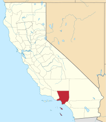
 Location of Carson in Los Angeles County, California | |
 Carson, California Location in the United States | |
| Coordinates: 33°50′23″N 118°15′35″W | |
| Country | |
| State | |
| County | |
| Incorporated | February 20, 1968[1] |
| Government | |
| • Type | Council-Manager |
| • City council[2] | Mayor Albert Robles Mayor Pro Tem Elito M. Santarina Lula Davis-Holmes Jawane Hilton Vacant Seat |
| • City Treasurer | Monica Cooper, |
| Area | |
| • Total | 18.97 sq mi (49.12 km2) |
| • Land | 18.72 sq mi (48.49 km2) |
| • Water | 0.24 sq mi (0.63 km2) 1.29% |
| Elevation | 39 ft (12 m) |
| Population | |
| • Total | 91,714 |
| • Estimate (2019)[6] | 91,394 |
| • Rank | 86th in California |
| • Density | 4,953.79/sq mi (1,912.46/km2) |
| Time zone | UTC−8 (Pacific) |
| • Summer (DST) | UTC−7 (PDT) |
| ZIP codes | 90745–90747, 90749, 90810, 90895[7] |
| Area code(s) | 310/424[8] |
| FIPS code | 06-11530[9] |
| GNIS feature IDs | 1660441,[10] 2409399 |
| Website | ci |
History
The year 1921 marked the first drilling for oil at Dominguez Hill, on the northwest side of the Dominguez Rancho, site of the famous battle during the Mexican–American War called the Battle of Dominguez Rancho in 1846. The mineral rights to this property were owned by Carson Estate Company, the Hellman Family, the Dominguez Estate Company, and the Burnham Exploration Company of Frederick Russell Burnham. On September 7, 1923, Burnham Exploration partnering with Union Oil brought in the first producer on the site: Callender No. 1-A well at a depth of 4,068 feet (1,240 m) and 1,193 barrels per day (189.7 m3/d).[15] Before long a number of refineries were up and running, with over 350 oil derricks, tank farms, and sprawling industrial complexes becoming a familiar part of the scenery. The principal leases were with Shell Oil Company and Union Oil of California and the first two wells were located west of Central Avenue and north of Victoria Street. Oil led to an increase in jobs in the community and a subsequent post-war population surge. An average of 300 barrels per day (48 m3/d) was produced from each of these wells through 1960.
In 2011, Shell was ordered by the Los Angeles Regional Water Quality Control Board to clean up the Carousel neighborhood after benzene and methane gas contamination was discovered, as well as soil and groundwater contamination.[16]
Geography
| Carson, California | ||||||||||||||||||||||||||||||||||||||||||||||||||||||||||||
|---|---|---|---|---|---|---|---|---|---|---|---|---|---|---|---|---|---|---|---|---|---|---|---|---|---|---|---|---|---|---|---|---|---|---|---|---|---|---|---|---|---|---|---|---|---|---|---|---|---|---|---|---|---|---|---|---|---|---|---|---|
| Climate chart (explanation) | ||||||||||||||||||||||||||||||||||||||||||||||||||||||||||||
| ||||||||||||||||||||||||||||||||||||||||||||||||||||||||||||
| ||||||||||||||||||||||||||||||||||||||||||||||||||||||||||||
According to the United States Census Bureau, Carson has an area of 19.0 square miles (49 km2). 18.7 square miles (48 km2) of it is land and 0.2 square miles (0.52 km2) of it (1.29%) is water.
Carson is bordered by West Rancho Dominguez on the north, Compton on the northeast, Rancho Dominguez and Long Beach on the east, Wilmington on the south, and West Carson and Harbor Gateway on the west.
Climate
Carson experiences a warm-summer Mediterranean climate (Köppen climate classification Csb), similar to that of the Los Angeles Basin with noticeably cooler temperatures during the summer due to the nearby Pacific Ocean (~6–8 miles). Rainfall is scarce during the summer in Carson but receives enough rainfall throughout the year to avoid Köppen's BSh (semi-arid climate). Carson, like many of the Southern California coastal areas, is subject to a late spring/early summer weather phenomenon called "June Gloom." This involves overcast or foggy skies in the morning which yield to sun by early afternoon.
Demographics
2010
The 2010 United States Census[17] reported that Carson had a population of 91,714. The population density was 4,835.2 people per square mile (1,866.9/km2). The racial makeup of Carson was 21,864 (23.8%) White (7.7% Non-Hispanic White),[18] 21,856 (23.8%) African American, 518 (0.6%) Native American, 23,522 (25.6%) Asian (20.9% Filipino, 0.8% Japanese, 0.8% Korean, 0.5% Chinese, 0.4% Vietnamese, 0.4% Asian Indian, 0.2% Cambodian, 0.1% Pakistani, 0.1% Thai), 2,386 (2.6%) Pacific Islander (2.2% Samoan, 0.2% Guamanian, 0.1% Native Hawaiian), 17,151 (18.7%) from other races, and 4,417 (4.8%) from two or more races. Hispanic or Latino of any race were 35,417 persons (38.6%) (32.6% Mexican, 1.1% Salvadoran, 1.0% Guatemalan, 0.6% Puerto Rican, 0.3% Cuban, 0.2% Honduran, 0.2% Peruvian, 0.2% Ecuadorian).
The Census reported that 90,411 people (98.6% of the population) lived in households, 1,170 (1.3%) lived in non-institutionalized group quarters, and 133 (0.1%) were institutionalized.
There were 25,432 households, out of which 10,980 (43.2%) had children under the age of 18 living in them, 14,178 (55.7%) were married couples living together, 4,787 (18.8%) had a female householder with no husband present, 1,761 (6.9%) had a male householder with no wife present. 3,776 households (14.8%) were made up of individuals, and 1,790 (7.0%) had someone living alone who was 65 years of age or older. The average household size was 3.56. There were 20,726 families (81.5% of all households); the average family size was 3.90.
| Historical population | |||
|---|---|---|---|
| Census | Pop. | %± | |
| 1960 | 38,059 | — | |
| 1970 | 71,150 | 86.9% | |
| 1980 | 81,221 | 14.2% | |
| 1990 | 83,995 | 3.4% | |
| 2000 | 89,730 | 6.8% | |
| 2010 | 91,714 | 2.2% | |
| Est. 2019 | 91,394 | [6] | −0.3% |
| U.S. Decennial Census[19] | |||
The population was spread out, with 21,992 people (24.0%) under the age of 18, 9,964 people (10.9%) aged 18 to 24, 23,105 people (25.2%) aged 25 to 44, 24,013 people (26.2%) aged 45 to 64, and 12,640 people (13.8%) who were 65 years of age or older. The median age was 37.6 years. For every 100 females, there were 91.9 males. For every 100 females age 18 and over, there were 88.5 males.
There were 26,226 housing units at an average density of 1,382.6 per square mile (533.8/km2), of which 19,529 (76.8%) were owner-occupied, and 5,903 (23.2%) were occupied by renters. The homeowner vacancy rate was 1.3%; the rental vacancy rate was 3.7%. 68,924 people (75.2% of the population) lived in owner-occupied housing units and 21,487 people (23.4%) lived in rental housing units.
2000
As of the census[9] of 2000, there were 89,730 people, 24,648 households, and 20,236 families residing in the city. The population density was 4,762.2 inhabitants per square mile (1,838.9/km2). There were 25,337 housing units at an average density of 1,344.7 per square mile (519.2/km2). The racial makeup of the city was 25.69% White, 25.41% Black or African American, 0.56% Native American, 22.27% Asian, 2.99% Pacific Islander, 17.98% from other races, and 5.09% from two or more races. 34.92% of the population were Hispanic or Latino of any race.
There were 24,648 households, out of which 39.2% had children under the age of 18 living with them, 58.7% were married couples living together, 17.2% had a female householder with no husband present, and 17.9% were non-families. 14.2% of all households were made up of individuals, and 5.9% had someone living alone who was 65 years of age or older. The average household size was 3.59 and the average family size was 3.92.
Age ranges of residents were 28.4% under the age of 18, 9.9% from 18 to 24, 28.5% from 25 to 44, 22.5% from 45 to 64, and 10.7% who were 65 years of age or older. The median age was 34 years. For every 100 females, there were 93.3 males. For every 100 females age 18 and over, there were 89.4 males.
According to a 2006 estimate, the median income for a household in the city was $60,457, and the median income for a family was $66,468.[20] Males had a median income of $33,579 versus $31,110 for females. The per capita income for the city was $17,107. About 7.2% of families and 9.3% of the population were below the poverty line, including 10.9% of those under age 18 and 8.6% of those age 65 or over. Carson has the distinction of being the only incorporated city in the United States where the black population has a higher median income than the white population.[21]
Economy
Top employers
As of 2013, the top ten employers in the city were:[22]
| # | Employer | # of Employees |
|---|---|---|
| 1 | Prime Wheel Corporation | 417 |
| 2 | See's Candy Shops Inc. | 404 |
| 3 | Arconic | 385 |
| 4 | Mag Aerospace Industries | 377 |
| 5 | Cedarlane Natural Foods Inc. | 302 |
| 6 | Sourcecorp Bps Inc. | 301 |
| 7 | General Mills Operations LLC | 287 |
| 8 | Xerox Education Services Inc. | 278 |
| 9 | The Pepsi Bottling Group | 276 |
| 10 | Pacific Bell | 273 |
Other companies based in Carson include Bristol Farms and Ducommun.
Former companies
Nissan previously had its North American headquarters in Carson. The 42-acre (17 ha) property consisted of 13 buildings, with a total of 700,000 square feet (65,000 m2) of office and light industrial space. One of the buildings, a nine-story tower, had the Nissan logo on it. Vincent Roger of the Los Angeles Times wrote that it "was a familiar sight to drivers passing the intersection of the Harbor and San Diego freeways."[23] Around 2006 the company had 1,500 employees at the headquarters.[24] In 2005 a leak revealed that Nissan planned to move its offices to Tennessee. In the summer of 2006, the Nissan headquarters completed the move.[23] Over half of the employees chose to stay in the Los Angeles area.[24]
Arts and culture
County of Los Angeles Public Library operates the Carson Regional Library and the Dr. Martin Luther King Library. Both libraries are in Carson.
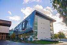
Carson is the site of California State University, Dominguez Hills (CSUDH). CSUDH is a major commuter school, particularly for students from the surrounding cities of Long Beach, Gardena, and Compton. It was founded as "South Bay College" and then renamed California State University at Palos Verdes. In the wake of the 1965 Watts rebellion, it moved to the City of Carson to meet a significant need for higher education opportunities in the largely black south suburbs of Los Angeles. Today it is among the most racially diverse campuses in the United States. The student body does not have a racial or ethnic majority.[25] In 1965, Carson was chosen as the home for the relocating university over the communities of Friendship Park, Fort MacArthur and Torrance.
Carson is also the location of Dignity Health Sports Park, a sports complex including a soccer-specific stadium used by the Los Angeles Galaxy, the Los Angeles Sol, from 2005 to 2014, C.D. Chivas USA, and for the 2017, 2018 and 2019 seasons only,[26] the Los Angeles Chargers of the NFL, a tennis stadium which hosts the yearly JP Morgan/Chase tennis tournament, and a track and field facility. It is also the training headquarters for the United States men's national soccer team. It opened in 2003, adjacent to CSUDH. The ADT Event Center is the only permanent indoor velodrome in the U.S. In July 2007, the Galaxy signed international soccer superstar David Beckham to the team. In 2011, International Boxing Hall of Fame Promoter, Bob Arum of Top Rank began publicizing professional boxing events.
One of the Goodyear Blimps was based in Carson, a fitting tribute to the 1st and 2nd U.S. and International Aviation Meets held at the Dominguez Hill Rancho in 1910 and 1911, which featured many blimps and zeppelins. The International Printing Museum, which has one of the largest collections of antique printing presses in the United States, is located in Carson.
Carson Mall, now SouthBay Pavilion, opened in 1973 and is located at the Avalon Boulevard exit off the San Diego Freeway (Interstate 405). Tenant stores include Burlington, IKEA, Target, ROSS, and 24 Hour Fitness.
Individual musicians and groups associated with Carson include Ab-Soul, Ras Kass, Boo-Yaa T.R.I.B.E., Bishop Lamont, Top Dawg Entertainment, and The Boys.
Sports
Two professional sports teams currently play their home games in Carson;
| Club | League | Venue | Established | Championships |
|---|---|---|---|---|
| Los Angeles Galaxy | Major League Soccer | Dignity Health Sports Park | 1995 (2003 in Carson) | 5 |
| Los Angeles Wildcats | XFL | Dignity Health Sports Park | 2020 | 0 |
The Los Angeles Chargers of the NFL played their home games in Carson from 2017 to 2019.
2028 Summer Olympics
Multiple events will be held in Carson during the 2028 Summer Olympics. Rugby, Modern Pentathlon, Tennis, Field Hockey and Track cycling will all be held in Carson.[27]
Proposed NFL Stadium
As Carson has large tracts of undeveloped land, unusual for a city in such close proximity to metropolitan Los Angeles,[28] various plans for the use of the land have been proposed. One such tract of land located at Del Amo Boulevard, west of the 405, has attracted particular attention as a potential site for a National Football League stadium.[29] An outdoor power center complex called Carson Marketplace was originally planned for the site. In February 2015, however, the Marketplace plans were scrapped in favor of a $1.2 billion National Football League stadium, backed by Goldman Sachs,[30] that would host both the Oakland Raiders and the then-San Diego Chargers.[31] The NFL had previously considered the site as a location for a stadium, but the plans stalled after it was discovered that the site was once used as a toxic waste dump and would require an extensive clean-up operation before construction was legally allowed to commence.[32] In May 2015, the Carson City Council allocated $50 million to clean up the site[33] for either the dual NFL stadium or the originally planned Carson Marketplace as a fallback should the NFL stadium not come to fruition.
On January 12, 2016, NFL owners rejected Carson's bid to host an NFL stadium in favor of the competing bid in Inglewood backed by Rams owner Stan Kroenke.[34] Despite this rejection, the Los Angeles Chargers played their home games in Carson temporarily from 2017 to 2019.
Government
Municipal government
According to the city's most recent Comprehensive Annual Financial Report, the city's various funds had $96.3 million in revenues, $81.8 million in expenditures, $611.4 million in total assets, $129.2 million in total liabilities, and $187.2 million in cash and investments.[35]
State and federal representation
In the California State Legislature, Carson is in the 35th Senate District, represented by Democrat Steven Bradford, and in the 64th Assembly District, represented by Democrat Mike Gipson.[36]
In the United States House of Representatives, Carson is in California's 44th congressional district, represented by Democrat Nanette Barragán.[37]
Education
Primary and secondary schools
Carson is served by the Los Angeles Unified School District and the Compton Unified School District.
High schools serving portions of Carson include Carson High School in Carson, Rancho Dominguez Preparatory School in Long Beach, and Banning High School in the Wilmington area of Los Angeles.[38] The area is within Board District 8.[39]
Circa 2019 there were plans to open a campus of the charter school Ganas Academy on the campus of the LAUSD public school Catskill Avenue Elementary School, but there was opposition to this move.[40]
Although the California Academy of Mathematics and Science is located in Carson on the campus of California State University, Dominguez Hills, it is actually a part of the Long Beach Unified School District. The school accepts residents of LBUSD, Compton USD, portions of LAUSD (including sections serving Carson), and other districts.
Infrastructure
Fire services
Fire protection in Carson is provided by the Los Angeles County Fire Department which operates out of Fire Stations 10, 36, 105, 116, and 127.[41] Ambulance transportation is provided by McCormick Ambulance Service Station 17.[42] The Los Angeles County Sheriff's Department (LASD) operates the Carson Station in Carson.[43]
Health care
The Los Angeles County Department of Health Services operates the Torrance Health Center in Harbor Gateway, Los Angeles, near Torrance and serving Carson.[44]
Post office
The United States Postal Service operates the Carson Post Office at 21350 Avalon Boulevard and the South Bay Pavilion Station in Suite 116 at 20700 Avalon Boulevard.[45][46]
Transportation
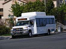
The city operates the Carson Circuit[47] bus that serves the local community and connects to other bus and rail transit services including the Los Angeles Metro Blue Line at the Del Amo Station, as well as the North-South Shuttle[48] which connects Carson to the Harbor Gateway Transit Center.
Notable people
- Forest Whitaker, director, producer, and Academy Award–winning actor
- Juanita Millender-McDonald, Democratic U.S. Congresswoman from 1996–2007
- Ashton Sanders, actor
- Brandy, singer/actress
- Ray J (Willie Norwood, Jr.), singer/actor
- The Boys (American band)
- Ras Kass, rapper
- Ab-Soul, rapper and member of group Black Hippy
- Reason, rapper
- Vince Ferragamo, NFL quarterback for Los Angeles Rams 1977-86, Super Bowl XIV, played for No. 1-ranked Nebraska 1976, an Academic All American, was LA City's MVP 1972
- Chad Brown, former National Football League referee
- Bob Whitfield, Stanford University graduate, NFL offensive lineman, Atlanta Falcons, New York Giants and Jacksonville Jaguars
- Wesley Walker, NFL wide receiver, NY Jets 1977-1989
- Danny Reece, NFL cornerback and punt returner, Tampa Bay Buccaneers 1976-1980, punt return leader 1979 and 1980
- The Game (Jayceon Taylor), rapper, lived in Carson age 7 to 15 while in foster care[49]
- Tommy "Tiny" Lister, actor, NCAA shot put champion and former professional wrestler
- Kia Stevens, also known as Awesome Kong and Amazing Kong in TNA Wrestling, professional wrestler
- Bishop Lamont, rapper
- Dr. Dre (Andre Young, Sr.), rapper/producer, lived in Carson during his middle school years[50]
- Ekene Ibekwe, University of Maryland basketball forward, 2012 Olympian (Nigerian National Team)
- Tammy Townsend, television actress
- Chuckii Booker, singer, songwriter
- Courtney Hall, former San Diego Chargers center and guard 1989–1999
- SoShy, (Deborah Epstein), a French singer and songwriter
- Elbert Watts, Green Bay Packers defensive back 1986
- Antwuan Dixon, professional skateboarder
- Erin Blunt, actor (Ahmad Abdul Rahim from Bad News Bears movies, Luther from What's Happening!!)
- Michael Quercio, musician
- Kris Richard, NFL player and coach
- Rex Salas, musician
- Brett Young, football player
- A$ton Matthews, rapper
- Demetrius Shipp Jr., actor[51]
In popular culture
- Reno 911![52]
- Jackie Brown[53]
- Gone in 60 Seconds
- Emergency! (Station 127 of the Los Angeles County Fire Department)
- Pros vs. Joes
- 10 Items or Less
Sister Cities
Carson has 4 sister cities:[54]

- Moreno Valley California
See also
Further reading
- Mizumoto Posey, Sandra (2017). "Made in occupied Japan: a collision and collusion of values in an occupied body". Frontiers: A Journal of Women Studies. 38 (1): 156–165. doi:10.5250/fronjwomestud.38.1.0156. JSTOR 10.5250/fronjwomestud.38.1.0156.CS1 maint: ref=harv (link) - Personal account of growing up in Carson.
References
- "California Cities by Incorporation Date". California Association of Local Agency Formation Commissions. Archived from the original (Word) on November 3, 2014. Retrieved August 25, 2014.
- "Elected Officials". City of Carson. Archived from the original on September 12, 2011. Retrieved January 14, 2015.
- "2016 U.S. Gazetteer Files". United States Census Bureau. Retrieved July 19, 2017.
- "Carson". Geographic Names Information System. United States Geological Survey. Retrieved October 11, 2014.
- "Carson (city) QuickFacts". United States Census Bureau. Retrieved April 8, 2015.
- "Population and Housing Unit Estimates". Retrieved May 21, 2020.
- "USPS – ZIP Code Lookup – Find a ZIP+ 4 Code By City Results". Retrieved January 18, 2007.
- "Number Administration System – NPA and City/Town Search Results". Archived from the original on September 26, 2007. Retrieved January 18, 2007.
- "U.S. Census website". United States Census Bureau. Retrieved 2008-01-31.
- "US Board on Geographic Names". United States Geological Survey. October 25, 2007. Retrieved January 31, 2008.
- "Archived copy". Archived from the original on October 14, 2013. Retrieved October 20, 2013.CS1 maint: archived copy as title (link)
- "Clarion Los Angeles, Carson, California". Hospitalsoup.com. August 16, 2007. Archived from the original on January 25, 2013. Retrieved February 9, 2012.
- Garner, Scott (September 14, 2018). "Neighborhood Spotlight: Carson is a hub for sports and affordable housing". Los Angeles Times. Retrieved February 16, 2019.
- "U.S Census Bureau QuickFacts". Retrieved March 12, 2020.
- Bruce A. Wells (September 16, 2010). "This Week in Petroleum History". The American Oil & Gas Historical Society. Retrieved October 6, 2010.
- Esquivel, Paloma (March 16, 2011). "Shell Oil ordered to clean up contaminated Carson neighborhood". Los Angeles Times. Retrieved March 16, 2011.
- "2010 Census Interactive Population Search: CA - Carson city". U.S. Census Bureau. Archived from the original on July 15, 2014. Retrieved July 12, 2014.
- "Archived copy". Archived from the original on September 16, 2012. Retrieved November 2, 2013.CS1 maint: archived copy as title (link)
- "Census of Population and Housing". Census.gov. Retrieved June 4, 2015.
- Archived February 11, 2020, at Archive.today
- "Carson – Income". Retrieved May 7, 2007.
- "Comprehensive Annual Financial Report" (PDF). Carson, California. Retrieved December 30, 2014.
- Vincent, Roger. "Nissan's old campus in South Bay gets 'flipped'." Los Angeles Times. March 3, 2010. Retrieved on March 7, 2014.
- Fujita, Akiko. "Toyota built Torrance into the second-largest home of Japanese Americans. Now, it's leaving" (Archive). The World. Public Radio International. May 16, 2014. Retrieved on May 27, 2015.
- "Our Apologies..." www4.csudh.edu. Archived from the original on October 6, 2017. Retrieved January 19, 2019.
- Fenno, Sam Farmer, Nathan (May 18, 2017). "Inglewood football stadium's opening will be delayed a year because of record rainfall - Los Angeles Times". Los Angeles Times.
- "Asset report" (PDF). la24-prod.s3.amazonaws.com.
- "Population Density Ranking - Mapping L.A. - Los Angeles Times". maps.latimes.com. Los Angeles Times.
- Garrick, Roger Showley, David (June 2, 2015). "Stadium talks open, Carson still looms".
- Logan, Tim. "In stadium financing game, Goldman Sachs dominates - Los Angeles Times". Los Angeles Times.
- Pringle, Paul. "State says Carson site ready for construction of NFL stadium - Los Angeles Times". Los Angeles Times.
- Pringle, Paul. "2003 Carson plan: Stadium site has been a tough sell - Los Angeles Times". Los Angeles Times.
- Fenno, Nathan. "Land deal finalized for proposed Carson NFL stadium - Los Angeles Times". Los Angeles Times.
- "Carson gracious in losing out on NFL stadium bid". January 12, 2016.
- City of Carson CAFR Archived September 27, 2011, at the Wayback Machine Retrieved 2009-08-18
- "Statewide Database". UC Regents. Archived from the original on February 1, 2015. Retrieved November 18, 2014.
- "California's 44th Congressional District - Representatives & District Map". Civic Impulse, LLC.
- "Proposed Changes to Rancho Dominguez Preparatory School Area Schools" (Archive). Los Angeles Unified School District. Retrieved on April 27, 2014.
- Board District 7 Map. Los Angeles Unified School District. Retrieved on November 24, 2008.
- "New charter school's possible campus-sharing with Carson elementary school causes rising tension between LAUSD, charter opponents". Daily Breeze. March 29, 2019. Retrieved April 13, 2019.
- "Battalion 7". Hometown Fire Stations. Los Angeles County Fire Department. Archived from the original on September 3, 2011.
- Archived January 12, 2010, at the Wayback Machine
- "Carson Station Archived January 26, 2010, at the Wayback Machine." Los Angeles County Sheriff's Department. Retrieved on January 21, 2010.
- "Torrance Health Center Archived February 1, 2015, at the Wayback Machine." Los Angeles County Department of Health Services. Retrieved on March 18, 2010.
- "Post Office Location – CARSON Archived February 10, 2009, at the Wayback Machine." United States Postal Service. Retrieved on December 6, 2008.
- "Post Office Location – SOUTHBAY PAVILION STATION Archived February 10, 2009, at the Wayback Machine." United States Postal Service. Retrieved on December 6, 2008.
- "Carson Circuit – City of Carson, CA". Ci.carson.ca.us. Archived from the original on September 23, 2011. Retrieved February 9, 2012.
- "North-South Shuttle – City of Carson, CA". Ci.carson.ca.us. Archived from the original on September 27, 2011. Retrieved February 9, 2012.
- Weiss, Jeff (August 25, 2011). "Compton Rapper Game Returns to an Industry That's Gone Soft". L.A. Weekly. Retrieved July 3, 2017.
- "Moving Company in Carson, California: Los Angeles Movers". www.lapromovers.com. Retrieved June 15, 2017.
- "Demetrius Shipp Jr. Has The Hardest Job In Hollywood—Playing 2Pac". Complex. Retrieved June 15, 2017.
- "Filming locations for "Reno 911!". IMDb.com. Retrieved November 12, 2012.
- "Film locations for Jackie Brown (1997)". Movie-locations.com. Retrieved February 9, 2012.
- "Archived copy". Archived from the original on February 7, 2017. Retrieved February 6, 2017.CS1 maint: archived copy as title (link)
External links
| Wikivoyage has a travel guide for Carson. |

| Authority control |
|
|---|