Jurupa Valley, California
Jurupa Valley is a city in Riverside County, California. The city borders San Bernardino County to the north, Riverside to the south and east, Eastvale and San Bernardino County to the west. On March 8, 2011, voters approved a ballot measure, designated as Measure A, to incorporate the area into its own city; as a result, the area has been an incorporated city since July 1, 2011.[4] According to the City's website:
The City of Jurupa Valley today is a mix of high and low-density residential development, rural farming and other agricultural activities, and a mix of commercial retail and industrial activity. Two primary transportation corridors traverse the Jurupa Valley area, Interstate 15 which runs north and south, and State Highway 60, which runs east and west. It has been in recent years that residential development and economic activity has increased, in particular in the areas adjacent to the I-15 and Highway 60. The City has significant capacity for expansion of both residential and commercial development activity in the future.[5]
Jurupa Valley, California | |
|---|---|
City | |
| City of Jurupa Valley | |
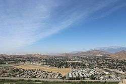 Jurupa Valley as seen from Mt. Rubidoux, 2013 | |
 Seal | |
| Nickname(s): "Jurupa" | |
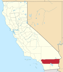
 Location of Jurupa Valley in Riverside County, California. | |
 Jurupa Valley Location in the United States  Jurupa Valley Jurupa Valley (California)  Jurupa Valley Jurupa Valley (the United States) | |
| Coordinates: 34°00′N 117°29′W | |
| Country | |
| State | |
| County | |
| Incorporated (city) | July 1, 2011[1] |
| Government | |
| • Type | Council-Manager |
| • Mayor | Anthony Kelly |
| • City Council | Council members
|
| Area | |
| • City | 43.68 sq mi (113.12 km2) |
| • Land | 42.94 sq mi (111.22 km2) |
| • Water | 0.74 sq mi (1.91 km2) |
| Population (2010) | |
| • City | 95,005 |
| • Estimate (2019)[3] | 109,527 |
| • Rank | 62nd in California 277th in the United States |
| • Density | 2,524.29/sq mi (974.58/km2) |
| • Metro | 4,527,837 |
| Time zone | UTC-8 (PST) |
| • Summer (DST) | UTC-7 (PDT) |
| ZIP codes | 92509, 91752 |
| Area code(s) | 951 |
| FIPS code | 06-37692 |
| GNIS feature ID | 2702867 |
| Website | jurupavalley |
The city of Jurupa Valley covers approximately 43.5 square miles (113 km2), and had an estimated population of 109,527 as of July 1, 2019. Residents of the area had previously voted on incorporation in 1992; however, voters rejected it as well as a competing ballot measure that would have incorporated Mira Loma.[4]
History
Jurupa Valley is rich in history dating back hundreds of years. "Jurupa" in Jurupa Valley derives its name from the first inhabitants of the area, Native Americans who called "Jurupa" their home. The Jurupa Valley area lies at the territorial boundaries of two different Tribes, the Gabrielino Tribe and the Serrano Tribe. Over the years, there have been various interpretations of the meaning of "Jurupa", from a greeting meaning "peace and friendship" to the first padre to visit the area, to a more widely recognized origination that "Jurupa" refers to the California Sagebrush common to the area. In 1838 the area became known as Rancho Jurupa under a land grant to Senõr Don Juan Bandini by the Mexican government. By the late 1800's the Jurupa Valley area began to live in the shadow of the more popular City of Riverside. Much of Jurupa Valley area has what once was a Riverside mailing address. Yet, settlement of the area in and around what is now the City of Riverside actually began in the Jurupa Valley many years before Riverside's founding.[6]
Notable Events in Jurupa Valley's History
The Wineville Chicken Coop murders — also known as the Wineville Chicken murders — were a series of abductions and murders of young boys that occurred in the city of Los Angeles and in Riverside County, California between 1926 and 1928. The case received national attention.
The Stringfellow Acid Pits, a toxic waste dump, and a Superfund site is located just north of the neighborhood of Glen Avon. The site was considered one of the most polluted sites in California and gained national news coverage in the early 1980s, and was linked with mismanagement and scandal in the U.S. Environmental Protection Agency.
Geography
Jurupa Valley is located north and west of the Santa Ana River, south of the Riverside-San Bernardino County line, and east of Interstate 15. It includes the neighborhoods of Mira Loma, Glen Avon, Sky Country, Indian Hills, Pedley, Rubidoux, Belltown, Jurupa, Jurupa Hills, and Sunnyslope.
| Climate data for Jurupa Valley, California | |||||||||||||
|---|---|---|---|---|---|---|---|---|---|---|---|---|---|
| Month | Jan | Feb | Mar | Apr | May | Jun | Jul | Aug | Sep | Oct | Nov | Dec | Year |
| Record high °F (°C) | 91 (33) |
92 (33) |
100 (38) |
101 (38) |
107 (42) |
110 (43) |
110 (43) |
112 (44) |
115 (46) |
108 (42) |
99 (37) |
92 (33) |
115 (46) |
| Average high °F (°C) | 67 (19) |
68 (20) |
71 (22) |
77 (25) |
80 (27) |
88 (31) |
93 (34) |
95 (35) |
91 (33) |
83 (28) |
74 (23) |
69 (21) |
80 (27) |
| Average low °F (°C) | 42 (6) |
44 (7) |
46 (8) |
48 (9) |
53 (12) |
58 (14) |
64 (18) |
66 (19) |
62 (17) |
53 (12) |
45 (7) |
42 (6) |
52 (11) |
| Record low °F (°C) | 24 (−4) |
27 (−3) |
28 (−2) |
31 (−1) |
32 (0) |
44 (7) |
49 (9) |
48 (9) |
42 (6) |
31 (−1) |
26 (−3) |
23 (−5) |
22 (−6) |
| Average precipitation inches (mm) | 3.45 (88) |
3.62 (92) |
2.91 (74) |
.88 (22) |
.26 (6.6) |
.03 (0.76) |
.05 (1.3) |
.15 (3.8) |
.27 (6.9) |
.56 (14) |
1.34 (34) |
2.72 (69) |
16.24 (412) |
| Average precipitation days | 6.6 | 7.2 | 5.3 | 3.5 | 1.4 | 0.3 | 0.8 | 1.0 | 1.3 | 2.5 | 4.4 | 6.4 | 40.7 |
Demographics
| Historical population | |||
|---|---|---|---|
| Census | Pop. | %± | |
| 2010 | 94,234 | — | |
| Est. 2019 | 109,527 | [3] | 16.2% |
| U.S. Decennial Census[7] | |||
Jurupa Valley was incorporated after the 2010 United States Census, but it is possible to determine an estimated population by summing up the results from the census-designated places of Glen Avon, Mira Loma, Pedley, Rubidoux and Sunnyslope.
According to the United States Census Bureau, as of July 1, 2017, the estimated population was 106,028.[8]
Politics
In the California State Legislature, Jurupa Valley is located in the 31st Senate District, represented by Democrat Richard Roth, and in the 60th Assembly District, represented by Democrat Sabrina Cervantes.
In the House of Representatives, the vast majority of Jurupa Valley is part of the 41st Congressional District, represented by Democrat Mark Takano. A small portion of the city is located in 42nd Congressional District, represented by Republican Ken Calvert. California is represented in the United States Senate by Democrats Dianne Feinstein and Kamala Harris.
Education
Jurupa Valley is home to the Jurupa Unified School District. The district operates 16 elementary schools, four middle schools, three continuation schools, and four high schools, including:[9]
- Jurupa Valley High School
- Rubidoux High School
- Patriot High School
- Rivercrest Preparatory

Transportation
Public transportation in Jurupa Valley is provided by Riverside Transit Agency.[10] The Metrolink serves the city at the Jurupa Valley/Pedley station (formerly Pedley Station). Commercial air transportation is available at the nearby Ontario International Airport. Jurupa Valley is also home to Flabob Airport, a small municipal airport.
The major freeways in Jurupa Valley are Interstate 15, which serves as the city's western border, and California State Route 60, which runs along the northern side of the city.

References
- "News : Press Enterprise". pe.com.
- "2016 U.S. Gazetteer Files". United States Census Bureau. Retrieved Jul 19, 2017.
- "Population and Housing Unit Estimates". Retrieved May 21, 2020.
- Stokley, Sandra (8 March 2011). "Jurupa cityhood approved". The Press-Enterprise. Retrieved 9 March 2011.
- "History | Jurupa Valley, CA". www.jurupavalley.org. Retrieved 2020-06-27.
- "History | Jurupa Valley, CA". www.jurupavalley.org. Retrieved 2020-06-27.
- "Census of Population and Housing". census.gov. Retrieved June 24, 2017.
- "QuickFacts: Jurupa Valley city, California". census.gov. Retrieved March 16, 2019.
- "Archived copy". Archived from the original on 2011-10-02. Retrieved 2011-03-24.CS1 maint: archived copy as title (link)
- "City of Jurupa Valley > Residents > Transportation". jurupavalley.org. Retrieved 24 September 2018.
External links
| Wikivoyage has a travel guide for Jurupa Valley. |
- City of Jurupa Valley
- Jurupa Unified School District web site
- Jurupa Valley Measure A official sample ballot
Places adjacent to Jurupa Valley, California | |
|---|---|
| Authority control |
|---|