Interstate 405 (California)
Interstate 405 (I-405) is a major north–south auxiliary Interstate Highway in Southern California. The entire route is known as the northern segment of the San Diego Freeway. I-405 is a bypass auxiliary route of I-5, running along the southern and western parts of the Greater Los Angeles urban area from Irvine in the south to near San Fernando in the north.
| ||||
|---|---|---|---|---|
| San Diego Freeway | ||||
%26groups%3D_249343cdecac428f067212d7587aa0a203704196.svg)
I-405 highlighted in red | ||||
| Route information | ||||
| Auxiliary route of I-5 | ||||
| Defined by Streets and Highways Code § 615 | ||||
| Maintained by Caltrans | ||||
| Length | 72.415 mi[1] (116.541 km) | |||
| Existed | 1964–present | |||
| Major junctions | ||||
| South end | ||||
| ||||
| North end | ||||
| Location | ||||
| Counties | Orange, Los Angeles | |||
| Highway system | ||||
| ||||
.svg.png)
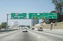
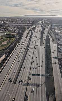
I-405 is a heavily traveled thoroughfare by both commuters and freight haulers along its entire length and is the busiest and most congested freeway in the United States.[2][3] The freeway's annual average daily traffic between exits 21 and 22 in Seal Beach reached 374,000 in 2008, making it the highest count in the nation.[4] It has played a crucial role in the development of dozens of cities and suburbs along its route through Los Angeles and Orange counties. It also serves Los Angeles International Airport (LAX), Long Beach Airport (LGB) and Orange County's John Wayne Airport (SNA).
Route description
Orange County
_01.JPG)
I-405 begins at the El Toro Y interchange in southeastern Irvine in Orange County, splitting from its parent I-5 and inheriting that route's San Diego Freeway title; I-5 continues north as the Santa Ana Freeway. The freeway passes immediately south of the Irvine Spectrum Center mall before intersecting with State Route 133 (SR 133). It then continues through Irvine, passing north of UC Irvine and then along the northern boundary of John Wayne International Airport. After passing the airport, the freeway enters Costa Mesa and has an interchange with SR 55. It passes South Coast Plaza before a partial interchange with SR 73, which serves as a partially-tolled bypass of I-405 between Costa Mesa and Laguna Niguel.
The freeway then travels through Fountain Valley and along the edges of Westminster and Huntington Beach before entering Seal Beach, where it begins to run concurrently with SR 22. It continues along the northern edge of Seal Beach, passing between Naval Weapons Station Seal Beach and Joint Forces Training Base Los Alamitos, before SR 22 splits from I-405 and continues west while the freeway turns north. I-405 then intersects the southern end of I-605 before crossing the San Gabriel River and entering Los Angeles County.
Los Angeles County
I-405 enters Los Angeles County in the city of Long Beach. It passes to the north of California State University, Long Beach and then along the south of Long Beach Airport. The freeway then intersects with I-710 before entering Carson, where it meets I-110. It also passes near California State University, Dominguez Hills and Dignity Health Sports Park, home of Major League Soccer club LA Galaxy.
After leaving Carson, I-405 briefly enters the city of Los Angeles by passing through the Harbor Gateway, a strip of land connecting San Pedro to the rest of the city. The freeway then continues to roughly parallel the contour of the coastline as it passes through the South Bay communities of Torrance, Lawndale, Redondo Beach, Hawthorne, and El Segundo. The freeway then encounters I-105 on the southeastern corner of LAX. It passes to the east of the airport, serving it with exits at Imperial Highway and Century Boulevard.
I-405 next passes through Inglewood, coming near the site of SoFi Stadium, future home to the Los Angeles Rams of the National Football League. It then passes through Westchester and Culver City where it meets SR 90, the Marina Freeway. It serves the Los Angeles neighborhoods of Mar Vista and West Los Angeles while passing a few miles east of Santa Monica, intersecting with I-10 in the process. The freeway continues into Westwood, passing just to the west of UCLA. It then passes the Getty Center as it ascends the Sepulveda Pass through the Santa Monica Mountains.
After cresting the mountains, I-405 descends into the San Fernando Valley, intersecting U.S. Route 101 (US 101) in the Sherman Oaks neighborhood of Los Angeles. The freeway then continues due north through the western part of the valley, passing east of Van Nuys Airport and California State University, Northridge. It intersects SR 118 in the Mission Hills area before ending in a merge with I-5 near San Fernando.
I-405 is part of the California Freeway and Expressway System,[5] and is part of the National Highway System,[6] a network of highways that are considered essential to the country's economy, defense, and mobility by the Federal Highway Administration.[7] The freeway is known as the San Diego Freeway, and parts of it are less commonly known as the Sepulveda Freeway (after Sepulveda Boulevard).[8]
Traffic congestion
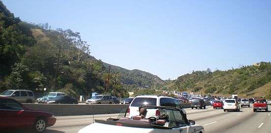
The freeway's congestion problems are legendary, leading to jokes that the road was numbered 405 because traffic moves at "four or five" miles per hour, or because drivers had spent "four or five" hours to travel anywhere. Indeed, average speeds as low as 5 miles per hour (8.0 km/h) are routinely recorded during morning and afternoon commutes, and its interchanges with the Ventura Freeway (US 101) and with the Santa Monica Freeway (I-10) each consistently rank among the five most congested freeway interchanges in the United States. As a result of these congestion problems, delays passing through the entire Los Angeles metropolitan area using this bypass route instead of merely using the primary route I-5 through Downtown may be present.
Of the major reasons for the excessively heavy traffic on the freeway, I-405 is the only major north–south freeway in the densely populated areas between West Los Angeles and Downtown, crossing the Santa Monica Mountains and connecting San Fernando Valley and the Los Angeles basin. Another parallel freeway is proposed to connect the Valley and the LA basin (the Laurel Canyon Freeway or La Cienega Freeway), but has faced upper class home-owner opposition.[9] Despite four years of construction disruptions, billions of dollars of public money, LA Times commentary claims traffic with the lane expansions is actually just as bad or worse.[10]
History
| |
|---|---|
| Location | Palos Verdes Peninsula - New Pine Creek |
| Existed | 1934–1964 |

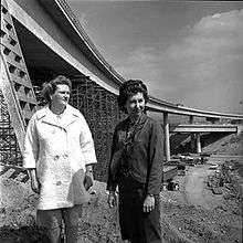
I-405 was approved as a chargeable Interstate (in other words, an Interstate financed with federal funds) in 1955. Construction began in 1957 with the first section, mostly north of LAX Airport, completed in 1961 (signed as SR 7) followed by sections west of I-605 within the following few years. The highway was renumbered to I-405 during the 1964 renumbering. The final section covering most of Orange County opened in 1969. Construction required the already existing Mulholland Highway to be re-routed 1.1 miles (1.8 km) to the south along a new 579-foot-long (176 m) bridge, the Mulholland Drive Bridge, to span I-405.[11]
"Carmageddon"
A section of I-405 was closed over the weekend of Friday, July 15, 2011 as part of the Sepulveda Pass Improvements Project.[12] Before the closing, local radio DJs and television newscasts referred to it as "Carmageddon" and "Carpocalypse", parodying the notion of Armageddon and the Apocalypse, since it was anticipated that the closure would severely impact traffic.[13][14]
In reality, traffic was lighter than normal across a wide area. The California Department of Transportation (Caltrans) reported that fewer vehicles used the roads than usual, and those who did travel by road arrived more quickly than on a normal weekend.[15] The Metrolink commuter train system recorded its highest-ever weekend ridership since it began operating in 1991. Ridership was 50% higher than the same weekend in 2010, and 10% higher than the previous weekend ridership record, which occurred during the U2 360° Tour in June 2011.[16]
In response to jetBlue Airlines' offer of special flights between Bob Hope Airport in Burbank and Long Beach Airport, a distance of only 29 miles (47 km), for $4,[17][18] a group of cyclists did the same journey in one and a half hours, compared to two and a half hours by plane (including a drive to the airport from West Hollywood 90 minutes in advance of the flight and travel time to the end destination).[19] There was also some debate about whether the Los Angeles area could benefit from car-free weekends regularly.[15]
The Los Angeles County Metropolitan Transportation Authority had full closure of a 10-mile (16 km) stretch of I-405 on the weekend of September 29–30, 2012, while construction crews worked to demolish a portion of the Mulholland Bridge.[20]
Researchers at the University of California, Los Angeles used the closure of I-405 to study particulate matter air pollution. The researchers took air samples before, during, and after the closure. The researchers found an 83% reduction in ultrafine particles, 55% reduction in fine particle matter, and 62% less black carbon.[21]
Sepulveda Pass Improvements Project
The $1 billion Sepulveda Pass Improvements Project added a high-occupancy vehicle lane and associated changes to freeway entrances, exits, and underpasses along a 10-mile stretch through the Sepulveda Pass between I-10 and U.S. 101/Ventura Boulevard.[22] The project was completed as a design-build in contrast to the traditional design-bid-build used typically in infrastructure improvement. This section of I-405 was closed for a weekend in mid-July 2011 to demolish the Mulholland Drive Bridge, and a 10-mile (16 km) section was closed for the last weekend of September 2012.[12]
Jamzilla was the name for the I-405 closure on President's Day Weekend 2014. There were lane closures and complete closures on I-405 starting February 14 at 10 p.m. until February 18 at 6 a.m. to pave and re-stripe the northbound lanes.[23]
On May 23, 2014, the 10-mile (16 km) high-occupancy vehicle lane was opened to traffic.[24]
Future
Manchester and Century Boulevard interchanges
Proposed changes between the Manchester and Century Boulevard interchanges in the City of Inglewood are to provide a new southbound on-ramp and a new northbound off-ramp for Arbor Vitae Street, to reconstruct and widened the Arbor Vitae Street over-bridge and replace the Century Boulevard overcrossing structure.[25] This work would reduce congestion on the approach to LAX. The California Department of Transportation has not yet issued a start date for this work.
Orange County
The Orange County Transportation Authority is currently preparing the design plans to add a High-occupancy toll (HOT) express lane and one mixed flow lane in each direction between SR 73 in Costa Mesa and I-605 in Seal Beach.[26] The I-405 Improvement Project is starting construction in 2018 and is scheduled to be completed in 2023.
Incidents
UCLA protest, 1966
Following the 1966 UCLA–USC rivalry football game, USC was voted into the Rose Bowl despite the UCLA team's having defeated the Trojans—with both teams having only one loss during the season. UCLA students protested by blocking the freeway's northbound lanes at Wilshire Boulevard.
O.J. Simpson chase, 1994
While dangerous high-speed chases along the San Diego Freeway are not uncommon, perhaps the most famous chase in its history was also one of the slowest. On the afternoon of June 17, 1994, former athlete and actor O.J. Simpson, who was accused of murdering his ex-wife Nicole Brown Simpson and waiter Ron Goldman, took to the freeway in a white Ford Bronco (driven by former teammate Al Cowlings) with police in pursuit. A widely televised low-speed chase ensued and ended hours later when Simpson returned to his Brentwood, Los Angeles, home and surrendered to law enforcement.[27]
Ennis Cosby murder, 1997
Ennis Cosby, the only son of Bill Cosby, was murdered along I-405 in Los Angeles on January 16, 1997, while fixing a flat tire.[28]
Sherman Oaks truck crash, 2019
On March 10, 2019, the portion of I-405 between the Ventura Freeway (US 101) and Burbank Boulevard in the Sherman Oaks area was closed in both directions as a propane tanker truck carrying more than 9,000 US gallons (34,000 l) of flammable gas overturned along the southbound lanes of I-405. No explosion resulted from the incident.[29]
In popular culture
I-405 was the location for the short film 405.
The Swedish rock band Europe's song "California 405" is featured on their 2015 studio album War of Kings.
Chuck Lorre used an end-of-show vanity card in 2013 to berate workers on the Interstate for their apparent lack of progress after five years.[30]
The Jimmy Eat World song "If You Don't, Don't", from the album Bleed America includes the line "Don't you know I'm thinking (know I'm thinking), driving 405 past midnight".
The Death Cab for Cutie song "405" on their second studio album, We Have the Facts and We're Voting Yes, may be incorrectly associated with California's I-405. The song is actually referring to I-405 in Seattle, as the band is from Bellingham.[31]
The song "Drive" on Halsey's 2015 album Badlands uses the story of a reckless drive on the I-405 to frame its relatively unstructured lyrics.[32]
Exit list
Except where prefixed with a letter, postmiles were measured on the road as it was in 1964, based on the alignment that existed at the time, and do not necessarily reflect current mileage. R reflects a realignment in the route since then, M indicates a second realignment, L refers an overlap due to a correction or change, and T indicates postmiles classified as temporary (for a full list of prefixes, see the list of postmile definitions).[1] Segments that remain unconstructed or have been relinquished to local control may be omitted. The numbers reset at county lines; the start and end postmiles in each county are given in the county column.
| County | Location | Postmile [1][33][34] | Exit [35] | Destinations | Notes |
|---|---|---|---|---|---|
| Orange ORA 0.23–24.18 | Irvine | 0.23 | Southern terminus; former US 101 south; no access to I-5 north; I-5 exit 94A | ||
| | 1A | Lake Forest Drive | No northbound exit | ||
| | 1B | Bake Parkway | No northbound exit | ||
| 0.95 | 1C | Irvine Center Drive | Signed as exit 1 northbound | ||
| | — | HOV access only; southbound exit and northbound entrance | |||
| 1.80 | 2 | No northbound exit to SR 133 north; SR 133 exit 8 | |||
| 2.88 | 3 | Shady Canyon Drive / Sand Canyon Avenue | |||
| 3.95 | 4 | Jeffrey Road / University Drive | |||
| 5.62 | 5 | Culver Drive | |||
| 6.92 | 7 | Jamboree Road | |||
| 7.80 | 8 | ||||
| Costa Mesa | 8.74 | 9A | SR 55 north exit 6, south exits 6A-B | ||
| | — | HOV access only | |||
| | 9B | Anton Boulevard / Avenue of the Arts | Northbound exit and entrance | ||
| 9.51 | 9B | Bristol Street | |||
| 10.28 | 10 | Southbound exit and northbound entrance | |||
| | 11 | South Coast Drive | Northbound exit only | ||
| 10.75 | 11A | Fairview Road | Signed as exit 11 northbound | ||
| 11.45 | 11B | Harbor Boulevard – Costa Mesa | Signed as exit 11 northbound | ||
| Fountain Valley | 12.47 | 12 | Euclid Street / Newhope Street / Ellis Avenue | ||
| 13.78 | 14 | Brookhurst Street – Fountain Valley | |||
| 14.82 | 15A | Warner Avenue east | Southbound exit and northbound entrance | ||
| Huntington Beach | 15.21 | 15B | Magnolia Street / Warner Avenue west | Signed as exit 15 northbound | |
| 16.54 | 16 | ||||
| Westminster | 17.75 | 18 | Bolsa Avenue / Goldenwest Street | Goldenwest Street is signed as Golden West St. | |
| 19.16 | 19A-B | Westminster Boulevard / Springdale Street | |||
| 20.56 | 20 | Bolsa Chica Road / Valley View Street | Southbound exit and entrance only | ||
| 20.75 | 21 | Southern end of SR 22 concurrency, Valley View St. not signed southbound | |||
| | — | HOV access only; southbound exit and northbound entrance | |||
| Seal Beach | 22.64 | 22 | Seal Beach Boulevard / Los Alamitos Boulevard | Former SR 35 | |
| 23.28 | 23 | Northern end of SR 22 concurrency; northbound exit and southbound entrance; I-605 exit 1A | |||
| | — | HOV access only; northbound exit and southbound entrance | |||
| Orange–Los Angeles county line | Seal Beach–Long Beach line | 23.28 | 23 | Southbound exit and northbound entrance; SR 22 exit 2, I-605 south exit 1A | |
| 24.04 | 24A | Signed as exit 24 northbound; I-605 north exit 1A, south exits 1B-C; SR 22 exit 2 | |||
| 0.00– 0.03 | San Gabriel River | ||||
| Los Angeles LA 0.00–48.64 | Long Beach | 0.45 | 24B | Studebaker Road | Southbound exit and northbound entrance |
| 1.11 | 25 | Palo Verde Avenue | |||
| 1.64 | 26A | Woodruff Avenue | No southbound exit | ||
| 2.18 | 26B | Bellflower Boulevard | Signed as exit 26 southbound | ||
| 3.32 | 27 | ||||
| 4.88 | 29 | Spring Street / Cherry Avenue – Signal Hill | Signed as exits 29A (south) and 29B (north) | ||
| Signal Hill | 5.39 | 29C | Orange Avenue | ||
| Long Beach | 6.08 | 30A | Atlantic Avenue | ||
| 6.34 | 30B | Long Beach Boulevard | Former SR 15 | ||
| 6.70 | 32A | Pacific Avenue | Southbound exit and northbound entrance | ||
| 7.60 | 32 | Signed as exits 32A (north) and 32B (south) northbound, and 32B (south) and 32C (north) southbound; I-710 exit 4 | |||
| 8.06 | 32C | Hughes Way / Santa Fe Avenue | Signed as exit 32D southbound | ||
| Carson | 8.78 | 33A | Alameda Street (SR 47 south) | ||
| 9.56 | 33B | Wilmington Avenue | |||
| 10.54 | 34 | Carson Street | |||
| 11.22 | 35 | Avalon Boulevard – Carson | Northbound exit to Avalon Boulevard south is via exit 34. | ||
| 12.60 | 36 | Main Street | Northbound exit and southbound entrance | ||
| 12.97 | 37A | Signed as exit 37 northbound; former US 6; I-110 exit 9 | |||
| Los Angeles | 13.28 | 37B | Vermont Avenue | Southbound exit and northbound entrance | |
| 13.83 | 38A | Normandie Avenue – Gardena | |||
| 14.40 | 38B | Western Avenue | |||
| Torrance | 15.45 | 39 | Crenshaw Boulevard – Torrance | ||
| 16.57 | 40 | Signed as exit 40A southbound; former SR 91 | |||
| 16.88 | 40B | Redondo Beach Boulevard – Redondo Beach | Southbound exit and northbound entrance | ||
| Lawndale | 17.59 | 42A | |||
| Redondo Beach | 18.23 | 42B | Inglewood Avenue | ||
| Hawthorne | 19.21 | 43 | Rosecrans Avenue – Manhattan Beach | Signed as exits 43A (east) and 43B (west) southbound | |
| 20.22 | 44 | El Segundo Boulevard – El Segundo | |||
| Los Angeles | R21.18 | 45A | Signed as exit 45 southbound; serves Los Angeles International Airport; I-105 east exit 2, west exit 2B | ||
| R21.22 | 45B | Imperial Highway | Southbound exit is part of exit 46. | ||
| Inglewood | 22.22 | 46 | |||
| 23.36 | 47 | Manchester Boulevard / La Cienega Boulevard / Florence Avenue | Manchester Boulevard was former SR 42. | ||
| Los Angeles | 24.27 | 48 | La Tijera Boulevard | ||
| 24.56 | 49A | Howard Hughes Parkway / Sepulveda Boulevard | Signed as exit 49 southbound | ||
| Culver City | 25.46 | 49B | Sepulveda Boulevard / Slauson Avenue (SR 90 east) | Northbound exit only; SR 90 exit 2 | |
| 25.95 | 50A | Jefferson Boulevard | Signed as exit 50B northbound | ||
| 25.95 | 50B | Signed as exit 50A northbound; no access from I-405 north to SR 90 east; SR 90 exit 2 | |||
| 27.20 | 51 | Culver Boulevard / Washington Boulevard – Culver City | |||
| 27.96 | 52 | Venice Boulevard (SR 187) / Washington Boulevard | |||
| Los Angeles | 29.16 | 53A | National Boulevard | Northbound exit and southbound entrance | |
| 29.54 | 53B | Signed as exit 53 southbound; I-10 exits 3A-B | |||
| 30.18 | 54 | Olympic Boulevard / Pico Boulevard | Southbound exit and northbound entrance; former SR 26 | ||
| 30.86 | 55A | Former US 66 | |||
| 31.54 | 55B | Wilshire Boulevard | Signed as exits 55B (east) and 55C (west) southbound | ||
| 32.50 | 56 | Montana Avenue | Northbound exit only; demolished[36] | ||
| 33.00 | 57A | Sunset Boulevard | Signed as exit 57 southbound | ||
| 33.29 | 57B | Moraga Drive | Northbound exit and entrance | ||
| 34.76 | 59 | Getty Center Drive | |||
| 36.03 | 61 | Mulholland Drive / Skirball Center Drive | |||
| Sherman Oaks, Los Angeles | 39.00 | 63A | Ventura Boulevard / Sepulveda Boulevard / Valley Vista Boulevard | ||
| 39.43 | 63B | US 101 exit 19A | |||
| 40.29 | 64 | Burbank Boulevard | |||
| Van Nuys, Los Angeles | 41.36 | 65 | Victory Boulevard – Van Nuys | ||
| 42.36 | 66 | Sherman Way – Van Nuys Airport | Signed as exits 66A (east) and 66B (west) northbound | ||
| North Hills, Los Angeles | 43.76 | 68 | Roscoe Boulevard – Panorama City | ||
| 44.74 | 69 | Nordhoff Street | |||
| Mission Hills, Los Angeles | 46.24 | 70 | Devonshire Street – Granada Hills | ||
| 46.85 | 71A | Signed as exit 71 southbound; no southbound exit to SR 118 east or northbound entrance from SR 118 west; SR 118 east exit 42A, west exit 42B | |||
| 47.24 | 71B | San Fernando Mission Boulevard | Northbound exit and southbound entrance | ||
| 47.75 | 72 | Rinaldi Street – Mission Hills | |||
| 48.64 | Northern terminus; no access to I-5 south; I-5 exit 158 | ||||
1.000 mi = 1.609 km; 1.000 km = 0.621 mi
| |||||
See also

References
- California Department of Transportation. "State Truck Route List". Sacramento: California Department of Transportation. Archived from the original (XLS file) on June 30, 2015. Retrieved June 30, 2015.
- "U.S. Highways With the Most Traffic". Time For Kids. Archived from the original on August 11, 2011.
- Santa Monica College Corsair News Article Archived August 15, 2007, at the Wayback Machine
- Office of Highway Policy Information (July 27, 2010). "Most Travelled Urban Highways Average Annual Daily Traffic". Federal Highway Administration. Retrieved January 26, 2013.
- "Article 2 of Chapter 2 of Division 1 of the California Streets and Highways Code". Sacramento: California Office of Legislative Counsel. Retrieved February 6, 2019.
- Federal Highway Administration (March 25, 2015). National Highway System: Los Angeles, CA (PDF) (Map). Scale not given. Washington, DC: Federal Highway Administration. Retrieved July 29, 2017.
- Natzke, Stefan; Neathery, Mike & Adderly, Kevin (June 20, 2012). "What is the National Highway System?". National Highway System. Washington, DC: Federal Highway Administration. Retrieved July 1, 2012.
- California Department of Transportation; California State Transportation Agency (January 2015). 2014 Named Freeways, Highways, Structures and Other Appurtenances in California. Sacramento: California Department of Transportation. pp. 82, 266. Archived from the original (PDF) on May 30, 2015. Retrieved May 30, 2015.
- "Crossroads of Confusion". Los Angeles Times. March 20, 1998. p. 2. Retrieved October 11, 2012.
- Hall, Carla (December 2, 2014). "Four ways the 405 freeway project has not made your life better". Los Angeles Times.
- Racine, Ned (January 11, 2011). "How the Mulholland Drive bridge was constructed". Los Angeles County Metropolitan Transportation Authority. Retrieved July 16, 2011.
- "Interstate 405: The 'Carmageddon', History, Myth and Trivia".
During 53 hours of closure, the north side of the Mulholland Bridge will be demolished as part of the $1 billion Sepulveda Pass Improvements Project.
- Gish, Judy (June 2011). "I-405 Summer Weekend Closure Planned". Inside Seven. California Department of Transportation District 7. Archived from the original on September 12, 2015. Retrieved January 26, 2013.
- Gostar, Reza (June 9, 2011). "Carpocalypse: The Weekend the 405 Freeway Will Stand Still – Brentwood, California Patch". Brentwood.patch.com. Archived from the original on July 18, 2012. Retrieved January 26, 2013.
- Mather, Kate; Bloomekatz, Ari; Saillant, Saillant (July 19, 2011). "In 'Carmageddon,' some see road map for the future". Los Angeles Times. Retrieved August 1, 2011.
- "Metrolink sets weekend ridership recording during 405 closure". The Source. Retrieved July 21, 2011.
- "JetBlue — 405 Freeway Closure? We're So Over It!". JetBlue. Retrieved January 26, 2013.
- "Great Circle Mapper". Gcmap.com. Retrieved January 26, 2013.
- "LA avoids feared 'Carmageddon' traffic jam". The Independent. London. July 17, 2011. Retrieved July 17, 2011.
- Morgan, Jared (July 19, 2012). "Carmageddon 2012 Announced, Full 405 Closure in September". Retrieved September 4, 2012.
- Winer, Arthur; Zhu, Yifang; Paulson, Suzanne (Spring 2014). "Carmageddon or Carmaheaven? Air Quality Results of a Freeway Closure" (PDF). Access. 44: 17–21.
- "Sepulveda Pass Improvement Project". Los Angeles County Metropolitan Transportation Authority. Retrieved July 15, 2011.
- Groves, Martha (February 14, 2014). "Jamzilla lane closures on the 405 Freeway begin tonight". Los Angeles Times. Retrieved October 4, 2014.
- "Carpool lane on North 405 Freeway opens". Los Angeles: KABC-TV. May 23, 2014. Retrieved May 23, 2014.
- District 7. "Interstate 405: On- and Off-Ramp Improvements at Arbor Vitae Street" (PDF). California Department of Transportation.
- "OCTA approves study of 405 widening project". Daily Pilot. February 10, 2010. Retrieved July 16, 2011.
- Mydans, Seth (June 19, 1994). "The Simpson Case: The Inmate; Simpson, Under Suicide Watch, Is Jailed on 2 Murder Charges". The New York Times. Retrieved December 9, 2007.
- Ayres, B. Drummond, Jr. (January 17, 1997). "Bill Cosby's Son Is Slain Along Freeway". The New York Times. Retrieved December 9, 2007.
- Hernandez, Jade (March 10, 2019). "405 Freeway closed in Sherman Oaks after tanker carrying 9,400 gallons of propane overturns". ABC7.com. Los Angeles: KABC-TV. Retrieved March 10, 2019.
- "CLP – Vanity Card #429". Retrieved October 4, 2014.
- As told in track nine of their iTunes Originals Album
- Sherman, Maria (August 21, 2015). "Halsey Shares Unrestrained New 'Badlands' Song, 'Drive'". Fuse. Retrieved December 17, 2017.
- "California Log of Bridges on State Highways: District 7" (PDF). Caltrans. October 2006. Archived from the original (PDF) on June 29, 2007. Retrieved September 19, 2019.
- California Department of Transportation, All Traffic Volumes on CSHS, 2005 and 2006
- Howe, Dan (April 17, 2007). "I-405 Northbound" (PDF). California Numbered Exit Uniform System. California Department of Transportation. Archived from the original (PDF) on August 20, 2016. Retrieved February 14, 2008.
Howe, Dan (April 17, 2007). "I-405 Southbound" (PDF). California Numbered Exit Uniform System. California Department of Transportation. Archived from the original (PDF) on August 20, 2016. Retrieved February 14, 2008. - "405 Freeway NB Montana Avenue Offramp Dies At 57". Los Angeles: KCBS-TV. November 24, 2013. Retrieved March 19, 2014.
External links
| Wikimedia Commons has media related to Interstate 405 (California). |