Crenshaw Boulevard
Crenshaw Boulevard is a principal north-south thoroughfare in Los Angeles, California, that runs through Crenshaw and other neighborhoods along a 23-mile route in the west-central part of the city.[1]
| Former name(s) | Angeles Mesa Drive |
|---|---|
| Namesake | George L. Crenshaw |
| Length | 23.46 mi (37.76 km) |
| Location | Los Angeles, Inglewood, Hawthorne, Torrance, Rancho Palos Verdes California, U.S. |
| Nearest metro station | |
| North end | Wilshire Boulevard in Los Angeles |
| South end | Crest Drive in Rancho Palos Verdes |
The street extends between Wilshire Boulevard in Mid-Wilshire, Los Angeles, on the north and Rolling Hills, on the south. Crenshaw marks the eastern boundaries of Gardena, Torrance, and Hawthorne.
The commercial corridor in the Hyde Park neighborhood is known as "the heart of African American commerce in Los Angeles".[2][3]
History
Crenshaw Boulevard was named after banker and Los Angeles real estate developer George Lafayette Crenshaw who also developed the affluent Lafayette Square.[4]
The southern end of Crenshaw Boulevard was at Adams Street until 1916-1918, when the road was extended between Adams on the north and Slauson Avenue on the south. The extension saved three miles in travel over the nearest through road (Western Avenue) and five miles over the nearest paved road (Vermont Avenue).[5][6]
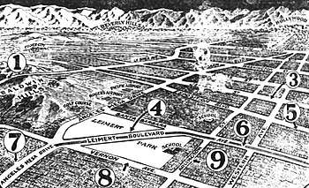
Until the 1950s,tracks for the 5 Line streetcar line[7]ran in the median between Leimert Boulevard[8] on the north close to Florence Ave on the south. Since the abandonment of the streetcars, the former railway median has been narrowed, the driving lanes improved and the street reconfigured for automobiles, buses and trucks.
Revitalization project
Many local residents were disappointed to see 71 mature street-line trees chopped down to make way for the Space Shuttle Endeavour to be moved from LAX to the California Science Center in nearby Exposition Park.[9][10]
Additional trees were removed for the under construction Crenshaw/LAX Line, but various officials have promised an aesthetically cohesive new revitalized boulevard with more trees being planted than were removed.[11] The project will also feature bike lanes, wider sidewalks, new Metro bus stops, street furniture with LED traffic lights and street lights.[12][9]
Transportation
Metro Local
Metro Local lines 40 and 210, Metro Rapid lines 710 and 740, and Torrance Transit line 10 serve Crenshaw Boulevard; Metro lines 210 and 710 run through the majority of Crenshaw Boulevard to Artesia Boulevard, Metro lines 40 and 740 from Crenshaw District to Hyde Park, and Torrance Transit line 10 south of Artesia Boulevard. The Metro C Line serves the Crenshaw station on Crenshaw Boulevard underneath Interstate 105, while the Metro E Line runs along Exposition Blvd and serves Expo/Crenshaw station at the intersection with Exposition Boulevard.
In the Crenshaw district, Crenshaw Boulevard and Baldwin Hills Crenshaw Plaza are served primarily by LADOT trolleys, buses and soon a light rail subway line with four Los Angeles County Metropolitan Transportation Authority bus lines that are:
- Metro Local Line 40 - South Bay Galleria - Patsaouras Transit Plaza via Martin Luther King Boulevard and Hawthorne Boulevard
- Metro Local Line 210 - South Bay Galleria - Hollywood/Vine B Line Station via Crenshaw Boulevard, Rossmore Avenue, and Vine Street
- Metro Rapid Line 710 - South Bay Galleria - Wilshire/Western D Line Station via Redondo Beach Boulevard and Crenshaw Boulevard
- Metro Rapid Line 740 - South Bay Galleria - Inglewood Transit Center - Expo/Crenshaw Station
Crenshaw Boulevard is also briefly served in the Crenshaw district by the following LACMTA lines:
- Metro Local Line 102 - LAX City Bus Center to Huntington Park via La Tijera Boulevard, Stocker Street, Exposition Boulevard and Jefferson Boulevard
- Metro Local Line 105 / Rapid Line 705 - West Hollywood - Vernon via La Cienega Boulevard, Barack Obama Boulevard and Vernon Avenue
Transit expansion
Crenshaw/LAX Line
The Crenshaw/LAX Line is currently under construction. It will transport passengers from the existing Expo/Crenshaw station to the planned Aviation/96th Street station and Metro Green Line stations.[13] It is projected to be completed in mid 2020.
Notable landmarks
- The intersection of Slauson Avenue and Crenshaw Boulevard was named Ermias “Nipsey Hussle” Asghedom Square in April 2019 to honor him and his contributions to the neighborhood.[14]
- Baldwin Hills Crenshaw Plaza
- Crenshaw High School
- Destination Crenshaw, 1.3-mile-long (2.1 km) open-air museum of African American history and culture
- The Holiday Bowl was a bowling alley and café known for being a center of ethnic diversity during the 1960s and 1970s. It featured a sushi bar known as the Sakiba Lounge with live musical acts with a Modernist Googie architecture style. It is City of Los Angeles Historic Cultural Monument #688.[15][16]
- Los Angeles Sentinel
- SpaceX Headquarters[17]
References
- Christopher Hawthorne, "Crenshaw Boulevard comes to a crossroads", Los Angeles Times, September 15, 2012.
- Robinson-Jacobs, Karen (May 2, 2001). "Noticing a Latin Flavor in Crenshaw". Los Angeles Times. Retrieved January 21, 2016.
- Meares, Hadley (2019-05-17). "How Crenshaw became black LA's main street". Curbed LA. Retrieved 2019-05-18.
- Parra, Alvaro (October 23, 2014). "Crenshaw Boulevard: Cruising Through the Decades". KCET. Retrieved May 3, 2020.
- "Road Project Is in Peril," Los Angeles Times August 20, 1916, image 23
- "After Many Delays," Los Angeles Times, January 27, 1918, image 82
- Los Angeles Railway in Brief - Map of Streetcar Routes
- "5 Line". Archived from the original on 2007-01-03. Retrieved 2013-09-05.
- Jennings, Angel "Tree removal along Crenshaw has residents stumped" Los Angeles Times, March 30, 2014
- Zahniser, David (May 9, 2019). "South L.A. was promised a Target. Millions of dollars later, it has a vacant lot". Los Angeles Times. Retrieved 2019-05-11.
- "Crenshaw Corridor Specific Plan" (PDF). City of Los Angeles. April 19, 2017. Archived (PDF) from the original on May 5, 2019. Retrieved May 4, 2019.
- "Crenshaw Boulevard Streetscape Plan" (PDF). planning.lacity.org. Retrieved 2017-06-05.
- "Crenshaw/LAX Transit Corridor (project website)". Metro (LACMTA). June 27, 2013. Retrieved 2013-09-11.
- Cosgrove, Jaclyn (April 9, 2019). "Crenshaw and Slauson intersection to be named in honor of Nipsey Hussle". Los Angeles Times. Retrieved 2019-04-10.
- "Game Over For Holiday Bowl?". November 21, 2008. Archived from the original on November 21, 2008. Retrieved January 25, 2018.
- "Monument Search Results Page". Cityplanning.lacity.org. Retrieved January 25, 2018.
- "SpaceX erects historic 16-story-tall rocket booster outside its Hawthorne headquarters". daily breeze.com. Retrieved 2017-06-08.
External links
