Puente Hills
The Puente Hills are a chain of hills, one of the lower Transverse Ranges, in an unincorporated area in eastern Los Angeles County, California, in the United States. The western end of the range is often referred to locally as the Whittier Hills.
| Puente Hills | |
|---|---|
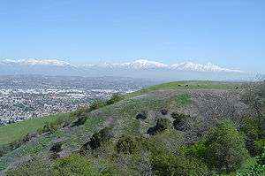 View of the San Gabriel Mountains from the Puente Hills | |
| Highest point | |
| Peak | Workman Hill |
| Elevation | 424 m (1,391 ft) |
| Geography | |
 Location of the Puente Hills in California [1] | |
| Country | United States |
| State | California |
| District | Los Angeles County |
| Range coordinates | 33°59′59.044″N 117°55′3.226″W |
| Topo map | USGS La Habra |
Geography
The Puente Hills lie to the south of the San Gabriel Valley and the Pomona Freeway (State Route 60), to the east of the San Gabriel River Freeway (Interstate 605), to the north of Whittier Boulevard, and to the west of the city of Diamond Bar and Chino Hills. Cities to its north are the City of Industry, Hacienda Heights, and Rowland Heights. To the south are Whittier, La Habra Heights, and Brea. The Brea-Olinda Oil Field, discovered in 1880 and still producing in 2014, is in the southernmost portion of the hills adjacent to the city of Brea.
Flora
The Puente Hills are in the California chaparral and woodlands ecoregion of the California Floristic Province. The remnant California native plants here are in the chaparral and oak woodland plant communities, with stands of California native grasses. Vascular Plants of the Whittier Hills, a floristic study, was completed by Julie A. Schneider Ljubenkov and Timothy S. Ross (2001), and published in Crossosoma. It built on the work of Bob Muns.[2]
Landmarks
Rio Hondo College is located at the foot of the western end of the hills, and the Puente Hills Landfill is nearby. Rose Hills Memorial Park occupies portions of the northern area. The highest point in the western hills is Workman Hill, named for the pioneer Workman family. The Puente Hills Mall is located north of the hills. Hsi Lai Temple in Hacienda Heights, the second largest Buddhist temple and monastery in the western hemisphere, is located in the hills.
In the 1953 film adaptation of H. G. Wells' science-fiction novel The War of the Worlds, the Puente Hills were the landing site of the first spacecraft in the Martian invasion.
In the scene from Back to the Future (1985 film), Doc Brown introduces the iconic Delorean time machine in the parking lot of Puente Hills Mall.

Parks
- Puente Hills Native Habitat Preserve
Puente Hills is home to the Puente Hills Landfill, the country's largest landfill, which closed in 2013. The high-tech landfill has begun offering tours.[3][4] The Puente Hills Landfill Native Habitat Preservation Authority directs the acquisition, restoration, and management of open space in the Puente Hills for preservation of the land to protect the biological diversity and provide opportunities for outdoor education and low-impact recreation, and scheduled hikes are offered.[5][6][7]
- Hellman Wilderness Park
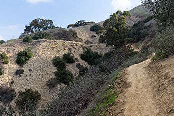
Hellman Wilderness Park is located in the western Puente Hills ("Whittier Hills") with trailheads in Whittier.[8] It is managed by the Puente Hills Habitat Preservation Authority.[9] It has trails into native coastal sage scrub habitats, and up to vistas of the Los Angeles Basin.[10]
- Schabarum Regional Park
Schabarum Regional Park is partially in the eastern Puente Hills, in Rowland Heights, eastern Los Angeles County, California. It has equestrian and hiking trails in the hills.[11][12]
Oil drilling

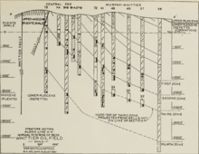
A commercial discovery was made in 1897, for what would become the Whittier Oil Field, when a well was drilled to a depth of 984 feet. The location was in the central area of production. By 1903, about 100 wells were in operation and by 1924, there were 163 commercial wells in operation.[13]
There has been a long history of oil drilling in the Puente Hills. In the early 20th century, several companies drilled, including Simon Murphy's Murphy Oil Company. Recently, Matrix Oil has proposed resumption of oil drilling on several acres in the Puente Hills.
Nearby ranges
See also
References
- "Puente Hills". Geographic Names Information System. United States Geological Survey. Retrieved 2009-05-03.
- Muns, Bob. "Flora of the Skyline Trail, Puente Hills, Los Angeles County". Tom Chester. Retrieved 28 May 2013.
- www.npr.org "The Nation's Largest Landfill Beckons Tourists"- access date: 6/7/2010
- Puentehillslandfill.org . access date: 6/7/2010
- Habitatauthority.org: park map Archived 2011-05-27 at the Wayback Machine
- Habitatauthority.org: image Archived 2011-05-27 at the Wayback Machine . access date: 6/7/2010
- LAMountains.com: Hellman Wilderness Park
- Puente Hills Habitat Preservation Authority website
- Hiking Around Turnbull Canyon Trail in Hellman Wilderness Park, Whittier.
- "Los Angeles County Department of Parks and Recreation -Parks - Full List of Parks - Peter F. Schabarum Regional Park". Archived from the original on 2014-04-07. Retrieved 2014-05-16.
- Schabarum Regional Park Support Foundation
- Holman, W.H. (1943). Whittier Oil Field, in Geologic Formations and Economic Development of the Oil and Gas Fields of California, Bulletin 118. San Francisco: State of California Dept. of Natural Resources Division of Mines. pp. 288–291.
External links
| Wikimedia Commons has media related to Puente Hills. |