South Los Angeles
South Los Angeles, formerly officially and sometimes still referred to as South-Central Los Angeles,[1][2] is a region in southern Los Angeles County, California, and mostly lies within the city limits of Los Angeles, just south of downtown.[3]
South Los Angeles | |
|---|---|
Regions of Los Angeles County | |
 The junction of the 110 and the 105 freeways | |
| Country | United States |
| State | California |
| County | Los Angeles |
| Cities | Los Angeles Inglewood Hawthorne |
| Unincorporated areas | View Park–Windsor Hills |
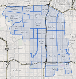
According to the Los Angeles Times, South Los Angeles (formerly known as South-Central Los Angeles) ”is defined on Los Angeles city maps as a 16-square-mile rectangle with two prongs at the south end.”[4] In 2003, the Los Angeles City Council renamed this area "South Los Angeles".[5]
The name South Los Angeles can also refer to a larger 51-square mile area that includes areas within the city limits of Los Angeles as well as five unincorporated neighborhoods in the southern portion of the County of Los Angeles.[6]
Geography
City of Los Angeles
The City of Los Angeles delineates the South Los Angeles Community Plan area as an area of 15.5 square miles.[7] Adjacent communities include West Adams, Baldwin Hills, and Leimert Park to the west, and Southeast Los Angeles (the 26-neighborhood area east of the Harbor Freeway) on the east.[8]
Los Angeles Times Mapping Project
According to the Los Angeles Times Mapping Project, the South Los Angeles region comprises 51 square miles, consisting of 25 neighborhoods within the City of Los Angeles as well as three unincorporated neighborhoods in the County of Los Angeles.[6]
Google Maps
Google Maps delineates a similar area to the Los Angeles Times Mapping Project with notable differences on the western border. On the northwest, it omits a section of Los Angeles west of La Brea Avenue. On the southwest, it includes a section of the City of Inglewood north of Century Boulevard.[3][lower-alpha 1]
Districts and neighborhoods
According to the Mapping L.A. survey of the Los Angeles Times, the South Los Angeles region consists of the following neighborhoods:[9]
City of Los Angeles
- Adams-Normandie
- Baldwin Hills/Crenshaw
- Broadway-Manchester
- Central-Alameda
- Chesterfield Square
- Exposition Park
- Florence
- Gramercy Park
- Green Meadows
- Harvard Park
- Historic South Central
- Hyde Park
- Jefferson Park
- Leimert Park
- Manchester Square
- Nevin
- South Park
- University Park
- Vermont Knolls
- Vermont Square
- Vermont Vista
- Vermont-Slauson
- Watts
- West Adams
- Westmont
Unincorporated County of Los Angeles Neighborhoods
History
Pre-1948
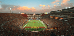
In 1880, the University of Southern California, and in 1920, the Doheny Campus of Mount St. Mary's University, were founded in South Los Angeles. The 1932 and 1984 Olympic Games took place near the USC campus at neighboring Exposition Park, where the Los Angeles Coliseum is located.
Until the 1920s, the South Los Angeles neighborhood of West Adams was one of the most desirable areas of the City. As the wealthy were building stately mansions in West Adams and Jefferson Park, the white working class was establishing itself in Crenshaw and Hyde Park. Affluent blacks gradually moved into West Adams and Jefferson Park.[10] As construction along the Wilshire Boulevard corridor gradually increased in the 1920s, the development of the city was drawn west of downtown and away from South Los Angeles.
In the eastern side of South Los Angeles (which the city calls the "Southeastern CPA") roughly east of the Harbor Freeway, the area grew southward in the late 1800s along the ever longer streetcar routes. Areas north of Slauson Boulevard were mostly built out by the late 1910s, while south of Slauson land was mostly undeveloped, much used by Chinese and Japanese Americans growing produce. In 1903, the farmers were bought out and Ascot Park racetrack was built, which turned into a "den of gambling and drinking". In the late 1910s the park was razed and freed up land for quick build-up of residential and industrial buildings in the 1920s.[11]
"By 1940, approximately 70 percent of the black population of Los Angeles was confined to the Central Avenue corridor"; the area of modest bungalows and low-rise commercial buildings along Central Avenue emerged as the heart of the black community in southern California.[1] Originally, the city's black community was concentrated around what is now Little Tokyo, but began moving south after 1900.[11] It had one of the first jazz scenes in the western U.S., with trombonist Kid Ory a prominent resident.[12] Under racially restrictive covenants, blacks were allowed to own property only within the Main-Slauson-Alameda-Washington box and in Watts, as well as in small enclaves elsewhere in the city.[10] The working- and middle-class blacks who poured into Los Angeles during the Great Depression and in search of jobs during World War II found themselves penned into what was becoming a severely overcrowded neighborhood. During the war, blacks faced such dire housing shortages that the Housing Authority of the City of Los Angeles built the virtually all-black and Latino Pueblo Del Rio project, designed by Richard Neutra.[13]
During this time, African Americans remained a minority alongside whites, Asians, and Hispanics; but by the 1930s those groups moved out of the area, African Americans continued to move in, and eastern South LA became majority black. Whites in previously established communities south of Slauson, east of Alameda and west of San Pedro streets persecuted blacks moving beyond established "lines", and thus blacks became effectively restricted to the area in between.[11]
1948–1960s
When the Supreme Court banned the legal enforcement of race-oriented restrictive covenants in 1948's Shelley v. Kraemer, blacks began to move into areas outside the increasingly overcrowded Slauson-Alameda-Washington-Main settlement area. For a time in the early 1950s, southern Los Angeles became the site of significant racial violence, with whites bombing, firing into, and burning crosses on the lawns of homes purchased by black families south of Slauson. In an escalation of behavior that began in the 1920s, white gangs in nearby cities such as South Gate and Huntington Park routinely accosted blacks who traveled through white areas. The black mutual protection clubs that formed in response to these assaults became the basis of the region's street gangs.[14]
As in most urban areas, 1950s freeway construction radically altered the geography of southern Los Angeles. Freeway routes tended to reinforce traditional segregation lines.[15]
1970s–1990s
Beginning in the 1970s, the rapid decline of the area's manufacturing base resulted in a loss of the jobs that had allowed skilled union workers to enjoy a middle class lifestyle. Downtown Los Angeles' service sector, which had long been dominated by unionized African Americans earning relatively high wages, replaced most black workers with newly arrived Mexican and Central American immigrants.[10]
Widespread unemployment, poverty and street crime contributed to the rise of street gangs in South Central, such as the Crips and Bloods. They became even more powerful with money from drugs, especially the crack cocaine trade, dominated by gangs in the 1980s.[14]
2000s–present
By the early 2000s, the crime rate of South Los Angeles had declined significantly. Redevelopment, improved police patrol, community-based peace programs, gang intervention work, and youth development organizations lowered the murder and crime rates to levels that had not been seen since the 1940s and '50s. Nevertheless, South Los Angeles was still known for its gangs at the time.[16] In mid-2003, the City Council of Los Angeles voted to change the name South Central Los Angeles to South Los Angeles on all city documents, a move supporters said would "help erase a stigma that has dogged the southern part of the city."[17][18]
On August 11, 2014, just two days after the shooting of Michael Brown in Ferguson, Missouri, a resident of South L.A., Ezell Ford, described as "a mentally ill 25-year-old man," was fatally shot by two Los Angeles police officers (see Shooting of Ezell Ford).[19] Since then, a number of protests focused on events in Ferguson have taken place in South Los Angeles.[20][21]
After the 2008 economic recession, housing prices in South Los Angeles recovered significantly, and by 2018, many had come to see South Los Angeles as a prime target for gentrification amid rising real estate values.[22] Real estate values in South Los Angeles were further bolstered by news that Los Angeles will host the 2028 Olympics, with many of the games to be hosted on or near the USC campus.[23]
Demographics
By the end of the 1980s, South Los Angeles had an increasing number of Hispanics and Latinos, mostly in the northeastern section of the region.[24]
According to scholars, "Between 1970 and 1990 the South LA area went from 80% black and 9% Latino to 50.3% black and 44% Latino."[25] This massive and rapid residential demographic change occurred as resources in the area were shrinking due to global economic restructuring described above and due to the federal government's decrease in funding of urban anti-poverty and jobs programs, and other vital social services like healthcare. The socio-economic context described here increased the perception and the reality of competition amongst Asians, blacks, and Latinos in South LA. The results from the 2000 census which show continuing demographic change coupled with recent economic trends indicating a deterioration of conditions in South LA suggest that such competition will not soon ease."[9]
In the 2014 census, the area of South Los Angeles had a population of 271,040. 61.0% of the residents were Hispanic or Latino, 28.7% were African American.[26]
Many African Americans from South Los Angeles have moved to Palmdale and Lancaster in the Antelope Valley.[27]
South Los Angeles has received immigrants from Mexico and Central America.[28]
Education
South Los Angeles is home to the University of Southern California, a private research university in the University Park neighborhood. It is California's oldest private research university.[29]
Public schools
Almost all of the South Los Angeles Area is served by the Los Angeles Unified School District. There are some schools not within the LAUSD that also serve the South Los Angeles Area, such as independent private schools or charter schools.
Los Angeles Unified School District
The following are some of the schools under the LAUSD which fall within the boundaries of the South Los Angeles region.
LAUSD Elementary Schools [30]
- Coliseum Street Elementary
- Graham Elementary
- Grape Street Elementary
- Manchester Avenue Elementary
- Russell Elementary
- Foshay Learning Center
- 20th Street Elementary
- 28th Street Elementary
- 68th Street Elementary
- 75th Street Elementary
- 107th Street Elementary
- 109th Street Elementary
- 112th Street Elementary
- 116th Street Elementary
- 118th Street Elementary
LAUSD Middle Schools[30]
- Audubon Middle School
- Carver Middle School
- Charles Drew Middle School
- Clinton Middle School
- Edwin Markham Middle School
- John Adams Middle School
- Mary McLeod Bethune Middle School
- Samuel Gompers Middle School
- Thomas Edison Middle School
- Los Angeles Academy Middle School
- Foshay Learning Center
LAUSD High Schools[30]
- Crenshaw High School
- Susan Miller Dorsey High School
- Locke High School
- John C Fremont High School
- Thomas Jefferson High School
- David Starr Jordan High School
- Diego Rivera Learning Complex
- King-Drew Senior High Medicine and Science Magnet
- Mervyn M Dymally Senior High
- Nathaniel Narbonne Senior High
- Santee Education Complex High School
- Foshay Learning Center
- Orthopaedic Hospital Medical Magnet High School
Community Colleges
- Los Angeles Southwest College, opened in 1967
- Los Angeles Trade Tech College
Landmarks
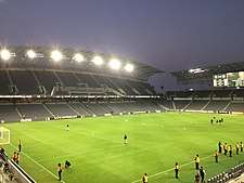
- Banc of California Stadium
- California African American Museum
- California Science Center
- Central Avenue
- Clark Library
- Coca-Cola Building
- Dunbar Hotel
- Exposition Park
- Fire Station No. 30
- Leimert Park
- Lincoln Theater
- Los Angeles Memorial Coliseum
- Los Angeles Sports Arena (demolished)
- Lucas Museum of Narrative Art (under construction)
- King/Drew Medical Center
- Second Baptist Church
- 28th Street YMCA
- University of Southern California
- Watts Towers
Notable people
Music and entertainment
- Ahmad Jones
- Barry White
- Charles Mingus
- Charles Wright & the Watts 103rd Street Rhythm Band
- CJ Mac
- Coolio
- Cozz
- Da Lench Mob
- Dom Kennedy
- Eric Dolphy
- Glasses Malone
- Hampton Hawes
- Ice Cube
- Ice-T
- Issa Rae
- Jay Rock
- John Cage, musician[31]
- Johnny "J"
- K-Dee
- Kausion
- Keb' Mo'
- Kevin McCall
- Kurupt
- L.V.
- Meghan Markle
- Montell Jordan
- Murs
- Nipsey Hussle
- O.F.T.B.
- Patrice Rushen
- Ras Kass
- Robin Russell, drummer, member of New Birth/Nite-Liters (band)
- Schoolboy Q
- Scott Shaw
- Sir Jinx
- Skee-Lo
- South Central Cartel
- Spider Loc
- Tiffany Haddish
- Tone Lōc
- Tyrese Gibson
- WC
- Young Maylay
- Etta James
- Ty Dolla $ign (rapper)
- Terrace Martin
Sports and athletes
Politicians
- Frederick Madison Roberts (South Central, State Assembly 1918–32)
- Augustus Hawkins (South Central, State Assembly 1932–62, U.S. House of Representatives 1962–1991)
- Mervyn M. Dymally (South Central State Assembly 1962–68 & 2002–08, California State Senate 1969–74, Lieutenant Governor of California 1975–79, U.S. House of Representatives 1981–93)
- Gilbert Lindsey (South Central, Los Angeles City Council 1962–91)
- Tom Bradley (South Central, Los Angeles City Council 1963–73, Mayor of the City of Los Angeles 1973–93)
- Billy G. Mills (South Central, Los Angeles City Council 1963–1974, Los Angeles Superior Court Judge 1974–??)
- Julian C. Dixon (South Central, State Assembly 1973–78, U.S. House of Representatives 1979–2000)
- Robert C. Farrell (South Central, Los Angeles City Council 1974–91)
- Yvonne Brathwaite Burke (South Central, State Assembly 1967–73, U.S. House of Representatives 1973–79, Los Angeles County Board of Supervisors 1979–80 and 1992–2008)
- Horace Hiller (1844–1898), member of the Los Angeles Common Council
- Nate Holden (Crenshaw, State Senator 1974–78, Los Angeles City Council 1987–2002)
- Diane Watson (Hyde Park, Los Angeles Unified School District Board 1975–73, State Senate 1978–98, United States Ambassador to Micronesia 1999–2000, U.S. House of Representatives 2001–2011)
- Maxine Waters (Watts, State Assembly 1976–1991, U.S. House of Representatives 1991–present)
- Rita Walters (Crenshaw, Los Angeles Unified School District Board 1979–91, Los Angeles City Council 1991–2001)
- Mark Ridley-Thomas (South Los Angeles, Los Angeles City Council 1991–2002, State Assembly 2002–06, California State Senate 2006–2008, Los Angeles County Board of Supervisors 2008–present)
- Curren Price (South Los Angeles, City Council 1993–97 and 2001–2006, State Assembly 2006–2009, State Senate 2009–present)
- Kevin Murray (Baldwin Hills, State Assembly 1994–98, State Senate 1998–2006)
- Roderick Wright (South Los Angeles, State Assembly 1996–2002, State Senate 2008–present)
- Herb Wesson (South Los Angeles, State Assembly 1998–2004, Los Angeles City Council 2005–present)
- Jan Perry (South Los Angeles, Los Angeles City Council 2002–present)
- Karen Bass (South Los Angeles, State Assembly 2004–2010, U.S. House of Representatives 2011–present)
- Holly Mitchell (South Los Angeles, State Assembly 2010–present)
- Marqueece Harris-Dawson (South Los Angeles, City Council 2015–present)
Artists, filmmakers and writers
- Ron Finley (South LA)
- Mark Bradford (Leimert Park)
- Catherine Opie (South LA)
- David Ayer (South LA)
- Charles Burnett (Watts)
- Cle Sloan
- Wanda Coleman (Watts)
- John Singleton (South L.A.)
- Ava DuVernay (South L.A.)
- Issa Rae (South L.A.)
- Kehinde Wiley (South L.A.)
Clergy
- Frederick K. C. Price (South Los Angeles)—founder and pastor of Crenshaw Christian Center
Government and infrastructure
The Los Angeles County Department of Health Services operates the South Health Center in Watts, Los Angeles, serving South Los Angeles.[32]
See also
- People
- James G. McAllister, president of the South Los Angeles Property Owners' Protective League and City Council member
- Robert C. Farrell (born 1936), journalist and member of the Los Angeles City Council, 1974–1991, prepared report on unemployment in Watts
References
- Mike Sonksen (June 20, 2018). "Inglewood Today: The History of South Central Los Angeles and Its Struggle with Gentrification". USC Lusk Center of Real Estate. Retrieved February 26, 2020.
- Laurajane Smith, Emma Waterton, Steve Watson (2012). The Cultural Moment in Tourism. Routledge. p. 206.
The City of Los Angeles officially changed the area's name from South Central to South Los Angeles in 2003 in an effort to change the perception of the area as one plagued by urban decay and violence, but residents still largely refer to it as South Central.
CS1 maint: multiple names: authors list (link) - "Map of South Los Angeles". Google. Retrieved 2009-05-28.
- Sims, Calvin. "In Los Angeles, It's South-Central No More".
- "The History of South Central Los Angeles and Its Struggle with Gentrification". KCET. 2017-09-13. Retrieved 2018-07-10.
- "South L.A.", Mapping L.A. website of the Los Angeles Times
- "Demographics" (PDF). 2014.
- "SouthLA". planning.lacity.org.
- Grant, et al. (1996), "African Americans"
- Darnell Hunt and Ana-Christina Ramon (eds.). Black Los Angeles: American Dreams and Racial Realities. New York: New York University. ISBN 978-0814737354.
- Southeast Los Angeles Community Plan, L.A. Preservation
- Clora Bryant; William Green; Buddy Collette; Steven Isoardi; Marl Young (1999). Central Avenue Sounds: Jazz in Los Angeles. University of California Press. p. 225. ISBN 978-0-520-22098-0.
- Ehrhard Bahr (2008). Weimar on the Pacific: German Exile Culture in Los Angeles and the Crisis of Modernism. University of California Press. p. 164. ISBN 978-0-520-93380-4.
- Dunn, William. 2007 The Gangs of Los Angeles. ISBN 978-0-595-44357-4
- John Buntin (2009). L.A. Noir. ISBN 978-0307352088.
- "Gangs of Los Angeles (map)". Google. 2007-05-07. Retrieved 2009-05-28.
- Matea Gold; Greg Braxton (2003-04-10). "Considering South-Central by Another Name". Los Angeles Times. p. 3. Retrieved 2014-07-17.
- RE: DISCONTINUING THE USE. OF THE TERM "SOUTH CENTRAL LOS ANGELES" ON ALL CITY DOCUMENTS
- Mather, Kate; et al. (2014-11-25). "Michael Brown protester handcuffed outside LAPD headquarters". Los Angeles Times. Retrieved 2014-12-14.
- Nash, Jim (2014-08-14). "Protesters in Leimert Park Join Nationwide 'Day of Rage' Over Ferguson Killing". KTLA 5. Retrieved 2014-12-14.
- Mather, Kate, and Richard Winton (2014-12-09). "LAPD investigating officer's use of baton during protest". capitalgazette.com. Retrieved 2014-12-14.
- "Beyond the "Black Beverly Hills": South L.A. Real Estate Heats Up With a New Hollywood Generation". The Hollywood Reporter. Retrieved 2018-09-19.
- "Mapped: the future sites of LA's 2028 Olympic games". Curbed LA. Retrieved 2018-09-19.
- ""Latinos Move to South-Central L.A. : Drawn by Low Rents, They Replace Blacks," '',''". Los Angeles Times. 1990-05-03. Retrieved 2014-07-17.
- Grant, David M., Melvin L. Oliver, and Angela D. James. 1996. "African Americans: Social and Economic Bifurcation," in Waldinger, Roger and Medhi Bozorgmehr. Ethnic Los Angeles, New York: Russell Sage Foundation
- "Demographics" (PDF). 2014.
- Lopez, Ricardo (2012-04-28). "Blacks in South L.A. have a bleaker jobs picture than in 1992". Los Angeles Times. Retrieved 2020-06-24.
- https://news.usc.edu/112088/lessons-from-the-transformation-of-south-los-angeles/
- "USC Graduate Admission". Gradadm.usc.edu. Retrieved 31 December 2017.
- "School Directory". Schooldirectory.lausd.net. Retrieved 31 December 2017.
- ""John Cage's Los Angeles"". Graphics.latimes.com. September 1, 2012. Retrieved 2014-07-17.
- "South Health Center." Los Angeles County Department of Health Services. Retrieved on March 18, 2010.
Notes
- Where other reliable sources are available for the boundaries of neighborhoods, they should be treated preferentially to Google Maps and Google Street View. It is difficult if not impossible to verify as they are subject to change and documentation and archives are not available.
Further reading
- Renwick, Lucille. "COVER STORY : THE MYTH OF South-Central : More a Stereotype Than a Place, It Is Defined By Ethnicity and Negative Media Images Rather Than Street Boundaries". Los Angeles Times. January 3, 1993.
- Kotkin, Joel (contributing editor of Opinion section) "COMMUNITY: Latinization of South Los Angeles" (Opinion). Los Angeles Times. May 28, 1995.
External links


- Image of the Vessels of Christ Ministry Choir in South Central Los Angeles, California, 1986. Los Angeles Times Photographic Archive (Collection 1429). UCLA Library Special Collections, Charles E. Young Research Library, University of California, Los Angeles.
- Image of South Central residents demonstrating against crime, Los Angeles, California, 1983. Los Angeles Times Photographic Archive (Collection 1429). UCLA Library Special Collections, Charles E. Young Research Library, University of California, Los Angeles.
South Los Angeles region, Los Angeles | ||
|---|---|---|
| Districts and neighborhoods |
|  |
| Points of interest | ||
| Neighboring cities and communities |
| |
| By topic |  | |
|---|---|---|
| Government | ||

| Authority control |
|
|---|