Hacienda Heights, California
Hacienda Heights is an unincorporated suburban community and census-designated place in Los Angeles County, California, United States. As of the 2010 census, the community had a total population of 54,038, up from 53,122 at the 2000 census. Hacienda Heights is the second largest census designated place in Los Angeles County by area and the county's second largest CDP by population.[3]
Hacienda Heights, California | |
|---|---|
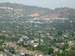 The view of Hacienda Heights, with Hsi Lai Temple and Puente Hills in the background | |
| Nickname(s): The Heights | |
| Motto(s): "Growing with Pride" [1] | |
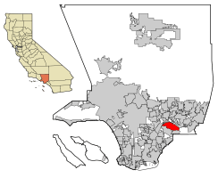 Location of Hacienda Heights in Los Angeles County, California. | |
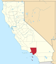
 Hacienda Heights, California Location in the United States | |
| Coordinates: 34°0′2″N 117°58′10″W | |
| Country | |
| State | |
| County | |
| Area | |
| • Total | 11.182 sq mi (28.962 km2) |
| • Land | 11.175 sq mi (28.944 km2) |
| • Water | 0.007 sq mi (0.018 km2) 0.06% |
| Elevation | 453 ft (138 m) |
| Population (2010) | |
| • Total | 54,038 |
| • Density | 4,800/sq mi (1,900/km2) |
| Time zone | UTC-8 (PST) |
| • Summer (DST) | UTC-7 (PDT) |
| ZIP code | 91745 |
| Area code(s) | 626, 562 |
| FIPS code | 06-31596 |
History
During Spanish rule, Hacienda Heights was a part of Rancho La Puente, which was operated by the nearby Mission San Gabriel Arcángel in San Gabriel.[4] The Rancho was eventually acquired by John A. Rowland and William Workman in 1845 via a Mexican land grant, and eventually acquired by Elias "Lucky" Baldwin.[5] In 1912, his descendant, Anita Baldwin, sold the property to Edwin Hart and Jet Torrance.[5] The pair subdivided the area and named it North Whittier Heights, which became known for avocado, citrus and walnut orchards, in 1913.[6] However, from the Great Depression era to the early 1940s, citrus growing became unprofitable because of pests and diseases, setting the impetus for the area's transformation into a suburb.[7]
Accelerating in the 1950s, suburban residential development[7] transformed Hacienda Heights into a residential or bedroom community.[8] In 1961, the Hacienda Heights Branch of the Los Angeles County Public Library opened.[7] The following year, in 1961, the area was renamed Hacienda Heights.[5] In 1964, the local newspaper, the Hacienda Heights Highlander, was established.[7]
Geography
Hacienda Heights is located at 34°0′2″N 117°58′10″W (34.000578, -117.969434)[9] in the eastern San Gabriel Valley bordering City of Industry to the North, Whittier to the West, La Habra Heights to the South, and Rowland Heights to the East along the Pomona Freeway - Route 60. Hacienda Heights is a predominantly residential neighborhood.
According to the United States Census Bureau, the community has a total area of 11.2 square miles (29 km2). 11.2 square miles (29 km2) of it is land and 0.06% is water.
Hacienda Heights also has the Puente Hills forming its 'green belt' southern border and much of its western border. The highest point is Workman Hill at 1,391 feet (424 m). Coyotes are common concern among residents.[10]
Demographics
| Historical population | |||
|---|---|---|---|
| Census | Pop. | %± | |
| 1970 | 35,969 | — | |
| 1980 | 49,422 | 37.4% | |
| 1990 | 52,354 | 5.9% | |
| 2000 | 53,122 | 1.5% | |
| 2010 | 54,038 | 1.7% | |
| U.S. Decennial Census[11] | |||
2010
The 2010 United States Census[12] reported that Hacienda Heights had a population of 54,038. The population density was 4,832.4 people per square mile (1,865.8/km²). The racial makeup of Hacienda Heights was 38% White, 12.6% Non-Hispanic White, 1.1% African American, 0.3% Native American, 39.3% Asian, 0.3% Pacific Islander, and 2.8% from two or more races. Hispanic or Latino of any race were 46%).[13]
The Census reported that 53,928 people (99.8% of the population) lived in households, 70 (0.1%) lived in non-institutionalized group quarters, and 40 (0.1%) were institutionalized.
There were 16,193 households, out of which 6,185 (38.2%) had children under the age of 18 living in them, 10,151 (62.7%) were opposite-sex married couples living together, 2,331 (14.4%) had a female householder with no husband present, 1,024 (6.3%) had a male householder with no wife present. There were 555 (3.4%) unmarried opposite-sex partnerships, and 93 (0.6%) same-sex married couples or partnerships. 2,111 households (13.0%) were made up of individuals and 1,047 (6.5%) had someone living alone who was 65 years of age or older. The average household size was 3.33. There were 13,506 families (83.4% of all households); the average family size was 3.59.
The population was spread out with 11,864 people (22.0%) under the age of 18, 5,184 people (9.6%) aged 18 to 24, 13,597 people (25.2%) aged 25 to 44, 15,071 people (27.9%) aged 45 to 64, and 8,322 people (15.4%) who were 65 years of age or older. The median age was 40.1 years. For every 100 females there were 94.8 males. For every 100 females age 18 and over, there were 92.4 males.
There were 16,650 housing units at an average density of 1,488.9 per square mile (574.9/km²), of which 12,720 (78.6%) were owner-occupied, and 3,473 (21.4%) were occupied by renters. The homeowner vacancy rate was 1.0%; the rental vacancy rate was 3.6%. 42,189 people (78.1% of the population) lived in owner-occupied housing units and 11,739 people (21.7%) lived in rental housing units. Median value of owner-occupied housing units, 2013-2017 was $545,400 with medium gross rent of $1,734.
Landmarks
The "Puente Hills Landfill Native Habitat Preservation Authority" supports public enjoyment and access of the nearby parkland in the Puente Hills.[14][15]
Hsi Lai Temple
Hsi Lai Temple (meaning "Coming West"), a branch of Fo Guang Shan (Buddha's Light Mountain) Temple of Taiwan, is the largest Buddhist temple in North America.[16][17] The temple encompasses 15 acres (61,000 m2) and a floor area of 102,432 sq ft (9,516.2 m2). The temple's Ming dynasty (1368–1644 AD) and Qing dynasty (1644–1911 AD) architecture is faithful to the traditional style of buildings, Chinese gardens, and statuary of ancient Chinese monasteries. Hsi Lai was built to serve as a spiritual and cultural center for those interested in learning Buddhism and Chinese culture.[18]
Government
Representation
In the state senate, Hacienda Heights is located in California's 32nd State Senate district, California's thirty-second state senate district is currently represented by Democrat Bob Archuleta
In the California State Assembly it is located in California's 57th State Assembly district, represented by Democrat Ian Calderon.
Federally, Hacienda Heights is located in California's 39th congressional district, which has an Even Cook PVI and is represented by Democrat Gil Cisneros.
Services
The Los Angeles County Sheriff's Department operates the Industry Station in the City of Industry, serving Hacienda Heights.[19]
The Los Angeles County Department of Health Services operates the Pomona Health Center in Pomona, serving Hacienda Heights.[20]
Cityhood
In 2003, voters were asked to decide whether the community should incorporate and become a city. Proponents argued that a new city would be able to better control development and provide increased police and fire service, while opponents argued that the new city would increase taxes and redevelop residential neighborhoods for revenue-generating businesses. Most of the prime commercial land had already been annexed by the City of Industry to escape taxes levied by the County on unincorporated areas. Ultimately the measure failed by about a 2-1 margin.
Education
The city is served by the Hacienda La Puente Unified School District.
High schools
- Los Altos High School
- Glen A. Wilson High School
- Valley Alternative High School
Middle schools
K-8 schools
- Mesa Robles School
- Cedarlane Academy
- St. Marks Lutheran School
Elementary schools
- Bixby Elementary
- Grazide Elementary
- Kwis Elementary
- Los Altos Elementary
- Los Molinos Elementary
- Los Robles Academy
- Palm Elementary
- Wedgeworth Elementary
- Hillgrove Elementary at 1234 Valencia Ave (1953-1984)
Glenelder Elementary School was merged with Cedarlane and Shadybend was closed down, too.
Notable people
- Caprice Bourret, actress and model
- Ralph Brown, football player
- William Campbell, California state legislator
- Shaun Cody, football player
- Andy DeMize, rock musician
- Fergie, singer and actress
- Jeff Garcia, voice actor and comedian
- Rob Hertel, football player
- Gary Jones, former national champion motocross racer
- Josh Keaton, actor and singer, The Spectacular Spider-Man
- Dong Kim, neurosurgeon
- David Lee, photographer and film director, Publisher of Destination Luxury
- Esperanza Martinez, painter
- Shane del Rosario, MMA fighter
- Ryan Sakoda, professional wrestler
- Michael Smith, former All-America basketball player at BYU and first-round pick of the Boston Celtics (13th overall), current television and color announcer for Los Angeles Clippers
- Jill Sterkel, 2-time Olympic champion freestyle swimmer
- Kevin Song, professional poker player
- Troy Tanner, professional volleyball player
- Brian Tee, actor
- Scott Williams, professional NBA basketball player
- Marc Yu, child musician
See also
- Rowland Heights, neighboring community immediately adjacent to Hacienda Heights on the east.
References
- Tedford, Daniel. "'Growing' with pot … er pride". InsideSocal. Retrieved December 17, 2016.
- U.S. Census
- http://ceo.lacounty.gov/forms/Estimate%20Unincorp.pdf
- Temple, Josette Laura (2004). Gentle Artist Of The San Gabriel Valley. Stephens Press. p. 47. ISBN 978-1-932173-31-4.
- Diaz, Enrique (2005). The San Gabriel Valley: A 21st Century Portrait. HPN Books. pp. 24–25. ISBN 978-1-893619-45-6.
- Haines, Ashley. "Head to the Hills: A History of Recreation in the Puente Hills" (PDF). Department of History. Claremont Graduate University. p. 21. Archived from the original (PDF) on 27 September 2011. Retrieved 11 August 2011.
- "Hacienda Heights Community Plan" (PDF). Los Angeles County Department of Regional Planning. 22 September 2010: 2–6. Cite journal requires
|journal=(help) - "Hacienda Heights; Information, Geography/Geology". 2011. Retrieved 11 August 2011.
- "US Gazetteer files: 2010, 2000, and 1990". United States Census Bureau. 2011-02-12. Retrieved 2011-04-23.
- Sahagun, Louis (2019-12-01). "Some say 'hazing' stops coyotes from becoming urbanized. Biologists aren't so sure". Los Angeles Times. Retrieved 2019-12-02.
- "Census of Population and Housing". Census.gov. Retrieved June 4, 2016.
- "2010 Census Interactive Population Search: CA - Hacienda Heights CDP". U.S. Census Bureau. Archived from the original on July 15, 2014. Retrieved July 12, 2014.
- "U.S. Census Bureau QuickFacts: Hacienda Heights CDP, California". www.census.gov. Retrieved 2019-05-30.
- http://www.habitatauthority.org/ . accessed 8/22/2010
- http://www.habitatauthority.org/pdf/HabAuthV2.jpg Archived 2011-05-27 at the Wayback Machine . accessed 8/22/2010
- Pan, Philip P. (August 8, 1993). "Good Neighbor : Hemisphere's Largest Buddhist Temple Wins Over Residents". Los Angeles Times.
- http://www.hsilai.org/ accessed 8/22/2010
- "Archived copy". Archived from the original on 2015-02-04. Retrieved 2014-11-15.CS1 maint: archived copy as title (link) accessed 8/22/2010
- "Industry Station Archived 2010-01-21 at the Wayback Machine." Los Angeles County Sheriff's Department. Retrieved on January 21, 2010.
- "Pomona Health Center." Los Angeles County Department of Health Services. Retrieved on March 27, 2010.
External links
- Puente Hills Preserve Park - activities and homepage
- Regional Chamber of Commerce - San Gabriel Valley
- Hacienda Heights Improvement Association
