Stevenson Ranch, California
Stevenson Ranch is a census-designated place in Los Angeles County, California. The community is located in the Santa Clarita Valley. Often incorrectly referred to as part of the city of Santa Clarita, the community does not actually fall within the city limits and is instead in an unincorporated area. It has many new suburban one- and two-story houses in new developments, with a median value of $1,034,600. Stevenson Ranch encompasses about 6.4 square miles (17 km2). About 1,000 acres (4.0 km2) are set aside as parks, recreation areas, and open space. Stevenson Ranch is set in the foothills of the Santa Susana Mountains and lies west of Interstate 5. One of the newer communities in the Santa Clarita Valley, which was ranked number 18 of the top 100 places to live by Money Magazine in 2006, This area backs up to the historic, oil-mining town of Mentryville, founded in 1875. A master-planned community, it was approved by the county in 1987. The population was 17,557 at the time of the 2010 census.
Stevenson Ranch, California | |
|---|---|
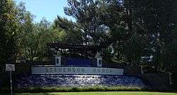 Stevenson Ranch Fountain in 2012 | |
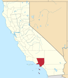
 Stevenson Ranch, California Position in Los Angeles County. | |
| Coordinates: 34°23′21″N 118°35′18″W | |
| Country | |
| State | |
| County | |
| Area | |
| • Total | 6.362 sq mi (16.478 km2) |
| • Land | 6.361 sq mi (16.475 km2) |
| • Water | 0.001 sq mi (0.002 km2) 0.01% |
| Elevation | 1,529 ft (466 m) |
| Population (2010) | |
| • Total | 17,557 |
| • Density | 2,800/sq mi (1,100/km2) |
| Time zone | UTC-8 (Pacific (PST)) |
| • Summer (DST) | UTC-7 (PDT) |
| ZIP Code | 91381 |
| Area code(s) | 661 |
| GNIS feature ID | 2583151[2] |
| Website | Official website |
It is home to the award winning California Distinguished and National Blue Ribbon Schools: Stevenson Ranch Elementary and Pico Canyon Elementary (part of the Newhall School District), and Rancho Pico Junior High, and West Ranch High School (part of the William S. Hart High School District), The Valencia Marketplace and Stevenson Ranch Shopping Center are popular shopping areas in the community. Six Flags Magic Mountain, an amusement park, is located about three miles north of the community.
The names of many streets located in Stevenson Ranch are those of famous authors (e.g., Thackeray).
It is also the filming location of several film and television productions, including the television show Weeds, a Showtime original series, as well as the feature film Pleasantville. Its master-planned nature is at the heart of the suburban commentary of Weeds, such as the "Little Boxes" song and sprawling development portrayed in the opening of the show.
It was the site of the 2001 James Beck Shootout.
Government and infrastructure
The Los Angeles County Sheriff's Department (LASD) operates the Santa Clarita Valley Station in Santa Clarita, serving Stevenson Ranch for law enforcement.[3] Traffic enforcement is handled by the California Highway Patrol (CHP). The city of Santa Clarita has tried unsuccessfully to annex Stevenson Ranch.
Demographics
The 2010 United States Census[4] reported that Stevenson Ranch had a population of 17,557. The population density was 2,759.6 people per square mile (1,065.5/km²). The racial makeup of Stevenson Ranch was 11,271 (64.2%) White (53.9% Non-Hispanic White),[5] 606 (3.5%) African American, 65 (0.4%) Native American, 4,028 (22.9%) Asian, 34 (0.2%) Pacific Islander, 765 (4.4%) from other races, and 788 (4.5%) from two or more races. Hispanic or Latino of any race were 2,827 persons (16.1%).
The Census reported that 17,557 people (100% of the population) lived in households, 0 (0%) lived in non-institutionalized group quarters, and 0 (0%) were institutionalized.
There were 5,663 households, out of which 3,006 (53.1%) had children under the age of 18 living in them, 3,761 (66.4%) were opposite-sex married couples living together, 533 (9.4%) had a female householder with no husband present, 231 (4.1%) had a male householder with no wife present. There were 251 (4.4%) unmarried opposite-sex partnerships, and 42 (0.7%) same-sex married couples or partnerships. Of the households, 828 (14.6%) were made up of individuals, and 227 (4.0%) had someone living alone who was 65 years of age or older. The average household size was 3.10. There were 4,525 families (79.9% of all households); the average family size was 3.48.
The population was spread out with 5,659 people (32.2%) under the age of 18, 1,261 people (7.2%) aged 18 to 24, 4,871 people (27.7%) aged 25 to 44, 4,668 people (26.6%) aged 45 to 64, and 1,098 people (6.3%) who were 65 years of age or older. The median age was 36.5 years. For every 100 females, there were 95.2 males. For every 100 females age 18 and over, there were 91.0 males.
There were 5,842 housing units at an average density of 918.2 per square mile (354.5/km²), of which 4,171 (73.7%) were owner-occupied, and 1,492 (26.3%) were occupied by renters. The homeowner vacancy rate was 1.3%; the rental vacancy rate was 5.1%. Of the population, 13,819 (78.7%) lived in owner-occupied housing units, and 3,738 people (21.3%) lived in rental housing units.
Climate
According to the Köppen Climate Classification system, Stevenson Ranch has a warm-summer Mediterranean climate, abbreviated "Csb" on climate maps.[6]
References
- U.S. Census Archived 2012-01-24 at WebCite
- U.S. Geological Survey Geographic Names Information System: Stevenson Ranch Census Designated Place
- "Santa Clarita Valley Station Archived 2010-01-23 at the Wayback Machine." Los Angeles County Sheriff's Department. Retrieved on January 21, 2010.
- "2010 Census Interactive Population Search: CA - Stevenson Ranch CDP". U.S. Census Bureau. Archived from the original on July 15, 2014. Retrieved July 12, 2014.
- "United States Census Bureau - Quick Facts".
- Climate Summary for Stevenson Ranch, California