Rancho Palos Verdes, California
Palos Verdes Estates is a city located in Los Angeles County, California atop the Palos Verdes Hills and the bluffs of the Palos Verdes Peninsula.
Rancho Palos Verdes, California | |
|---|---|
City | |
| City of Rancho Palos Verdes | |
.jpg) Aerial view of Trump National Golf Club | |
 Seal | |
| Nickname(s): RPV | |
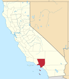
 Location of Rancho Palos Verdes in Los Angeles County, California | |
 Rancho Palos Verdes, California Location in the United States | |
| Coordinates: 33°45′30″N 118°21′51″W | |
| Country | |
| State | |
| County | |
| Incorporated | September 7, 1973[1] |
| Government | |
| • Mayor | John Cruikshank[2] |
| Area | |
| • Total | 13.47 sq mi (34.88 km2) |
| • Land | 13.47 sq mi (34.88 km2) |
| • Water | 0.00 sq mi (0.00 km2) 0% |
| Elevation | 220 ft (67 m) |
| Population | |
| • Total | 41,643 |
| • Estimate (2019)[6] | 41,530 |
| • Density | 3,145.06/sq mi (1,214.56/km2) |
| Time zone | UTC-8 (Pacific) |
| • Summer (DST) | UTC-7 (PDT) |
| ZIP code | 90275[7] |
| Area code(s) | 310/424[8] |
| FIPS code | 06-59514 |
| GNIS feature IDs | 255967, 2411516 |
| Website | rpvca |
Landmarks

The Point Vicente Interpretive Center is a premier whale-watching site that provides spectacular opportunities to view the annual migration of the Pacific gray whale from December through April. The center opened in 1984 with a mission to present and interpret the unique features and history of the Palos Verdes Peninsula. The almost 10,000-square-foot (930 m2) expanded Interpretive Center, reopened on July 15, 2006, features exhibits on the natural and cultural history of the peninsula, with a special emphasis on the Pacific gray whale. The Point Vicente Lighthouse, built in 1926, is adjacent to the center and is on the National Register of Historic Places. At another location along the coast, Wayfarers Chapel, designed by Lloyd Wright and built between 1949 and 1951, is also on the National Register of Historic Places.
The Portuguese Bend landslide, one of the largest continuously moving landslides in North America, is located along the southern coastal area. Together with the Palos Verdes Peninsula Land Conservancy in 2009, the city completed the acquisition of a total of two square miles of open space, the Palos Verdes Nature Preserve, the largest preserve of coastal open space north of San Diego and south of Santa Barbara. The site of the former Marineland of the Pacific (1954–87) was redeveloped and is now occupied by the Terranea Resort. Terranea Resort is a high-end Mediterranean-inspired resort that sits on a 102-acre estate that features 582 guest rooms and suites, including casitas and villas, and The Bungalows at Terranea, a collection of guest accommodations featuring spa and wellness-focused amenities. Other luxurious resort amenities spotlight eight distinct dining experiences, a full-service spa and fitness center, award-winning golf course, four swimming pools, kids’ club, ecological enrichment programs, and 135,000 sq. ft. of indoor and outdoor wedding and event space. The city is also home to Trump National Golf Course, one of eleven in the Trump portfolio of courses. The Salvation Army's School for Officer Training is located in Rancho Palos Verdes.
As with other cities on the Palos Verdes Peninsula, the city has had to find ways to control the population of wild peafowl. Frank A. Vanderlip spearheaded a group that bought 16,000 acres (6,500 ha) and began development of the peninsula. He is credited with introducing the birds here around 1910.[9] Some residents say the birds ruin their gardens, wake them up in the middle of the night with screeching, and defecate in their yards.[10]
Geography
Rancho Palos Verdes is located at 33°45′30″N 118°21′51″W (33.758216, -118.364256).[11]
According to the United States Census Bureau, the city has a total area of 13.5 square miles (35 km2), virtually all of which is land.
Demographics
| Historical population | |||
|---|---|---|---|
| Census | Pop. | %± | |
| 1980 | 36,577 | — | |
| 1990 | 41,659 | 13.9% | |
| 2000 | 41,145 | −1.2% | |
| 2010 | 41,643 | 1.2% | |
| Est. 2019 | 41,530 | [6] | −0.3% |
| U.S. Decennial Census[12] | |||
2010
The 2010 United States Census[13] reported that Rancho Palos Verdes had a population of 41,643. The population density was 3,092.6 people per square mile (1,194.1/km²). The racial makeup of Rancho Palos Verdes was 25,698 (61.7%) White (56.0% Non-Hispanic White),[14] 1,015 (2.4%) African American, 80 (0.2%) Native American, 12,077 (29.0%) Asian, 41 (0.1%) Pacific Islander, 748 (1.8%) from other races, and 1,984 (4.8%) from two or more races. Hispanic or Latino of any race were 3,556 persons (8.5%).
The census reported that 41,303 people (99.2% of the population) lived in households, 313 (0.8%) lived in non-institutionalized group quarters, and 27 (0.1%) were institutionalized.
There were 15,561 households, of which 5,187 (33.3%) had children under the age of 18 living in them, 10,465 (67.3%) were opposite-sex married couples living together, 1,218 (7.8%) had a female householder with no husband present, and 460 (3.0%) had a male householder with no wife present. There were 304 (2.0%) unmarried opposite-sex partnerships and 85 (0.5%) same-sex married couples or partnerships. 2,936 households (18.9%) were made up of individuals, and 1,810 (11.6%) had someone living alone who was 65 years of age or older. The average household size was 2.65. There were 12,143 families (78.0% of all households); the average family size was 3.03.
The population was diverse in age terms, with 9,248 people (22.2%) under the age of 18, 2,352 people (5.6%) aged 18 to 24, 7,045 people (16.9%) aged 25 to 44, 13,344 people (32.0%) aged 45 to 64, and 9,654 people (23.2%) aged 65 or older. The median age was 47.8 years. For every 100 females, there were 94.3 males. For every 100 females aged 18 and over, there were 90.1 males.
There were 16,179 housing units, at an average density of 1,201.5 per square mile (463.9/km²), of which 12,485 (80.2%) were owner occupied and 3,076 (19.8%) were occupied by renters. The homeowner vacancy rate was 0.6%; the rental vacancy rate was 6.4%. 33,015 people (79.3% of the population) lived in owner-occupied housing units, and 8,288 people (19.9%) lived in rental housing units.
According to the 2010 United States Census, Rancho Palos Verdes had a median household income of $118,893, with 4.5% of the population living below the federal poverty line.[14]. Since 2020, the median household income has risen to $133,286.
Education
The city is served by the Palos Verdes Peninsula Unified School District (PVPUSD), which includes Palos Verdes Peninsula High School and Palos Verdes High School, and the Los Angeles Unified School District (LAUSD, in the Eastview area of the city). Children living in Eastview have the option of attending public school in either the PVPUSD or the LAUSD. Also, Rolling Hills Country Day School (K-8) and Chadwick School (K-12) are well-known private schools that serve the area. Marymount California University, a private liberal arts institution offering bachelor's and master's degrees, is located in Rancho Palos Verdes.
The public school district which serves Rancho Palos Verdes consistently ranks top in the nation. The latest survey conducted by U.S. News, in 2013, reports that the PVPHS ranks 156th in the nation and 24th in the state,[15] while Palos Verdes High School (PVHS) in Palos Verdes Estates trails closely behind, at 269th in the nation and 43rd in the state.[16]
The Palos Verdes Library District operates three libraries on the Palos Verdes Peninsula, with Miraleste Library in Rancho Palos Verdes. Miraleste Library is open daily except on Sundays.[17]
Government
Rancho Palos Verdes is a General Law city (it has no charter). The City elects five council members at large to four-year terms in staggered, non-partisan elections on the first Tuesday in November of every odd-numbered year. The mayor and mayor pro tempore are elected annually by the residing city council members. At this time all of the city council has served as mayor at least once.
As of December 3, 2019, the city council consists of:[2]
- Mayor: John Cruikshank
- Mayor Pro Tem: Eric Alegria
- Councilmember: David Bradley
- Councilmember: Barbara Ferraro
- Councilmember: Ken Dyda
Mayor Cruikshank and Mayor Pro Tem Alegria have served on the Rancho Palos Verdes City Council since November 2017. Councilmember Dyda, at 84 years old, was the oldest person ever elected to the city council. He was also elected to the original city council when the city was established in 1973 and has served as mayor twice previously. Councilmembers Bradley and Ferraro were recently elected in November 2019.
As outlined in the City's Municipal Code, the city council hires a city manager to manage the day-to-day operation of the City and its staff. The current city manager is Ara Mihranian.
County, state, and federal representation
In the County of Los Angeles, Rancho Palos Verdes is located in the 4th Supervisorial District, represented by Janice Hahn.
In the California State Legislature, Rancho Palos Verdes is in the 26th Senate District, represented by Democrat Ben Allen, and in the 66th Assembly District, represented by Democrat Al Muratsuchi.[18]
In the United States House of Representatives, Rancho Palos Verdes is in California's 33rd congressional district, represented by Democrat Ted Lieu.[19]
Economy
Top employers
According to the City's 2014 Comprehensive Annual Financial Report,[20] the top employers in the city are:
| # | Employer | Employees |
|---|---|---|
| 1 | Palos Verdes Peninsula Unified School District | 1,970 |
| 2 | Terranea Resort | 730 |
| 3 | Trump National Golf Club | 260 |
| 4 | Marymount California University | 220 |
| 5 | Keller Williams Realty | 163 |
| 6 | The Canterbury | 115 |
| 7 | Belmont Village | 111 |
| 8 | Trader Joe's | 88 |
| 9 | Ralphs | 83 |
| 10 | Green Hills Memorial Park | 80 |
Emergency services
Fire protection in Rancho Palos Verdes is provided by the Los Angeles County Fire Department, and ambulance transport by McCormick Ambulance Service.[21]
The Los Angeles County Sheriff's Department operates the Lomita Station in the City of Lomita and provides law enforcement services for Rancho Palos Verdes.[22]
The Los Angeles County Department of Health Services operates Harbor-UCLA Medical Center in the Harbor Gateway, Los Angeles, near Torrance and serving Rancho Palos Verdes.[23]
Other nearby hospitals include Torrance Memorial Medical Center and Providence Little Company of Mary Hospital, both located in Torrance and San Pedro.
Notable people
Notable residents of Rancho Palos Verdes include professional poker player Barry Greenstein and artist John Van Hamersveld.[24] Merrill Moses, the Olympic water polo player, lived there. Chester Bennington of Linkin Park was once a longtime resident of Palos Verdes. Top-ten tennis player Eliot Teltscher also lived there.[25] Christen Press, a forward for the United States women's national soccer team and two-time World Cup champion, grew up there. Christopher John Boyce, a former American defense industry employee who was convicted for selling United States spy satellite secrets to the Soviet Union in the 1970s, grew up there.
References
- "California Cities by Incorporation Date". California Association of Local Agency Formation Commissions. Archived from the original (Word) on November 3, 2014. Retrieved August 25, 2014.
- "City Council". Rancho Palos Verdes. Retrieved January 6, 2017.
- "2016 U.S. Gazetteer Files". United States Census Bureau. Retrieved June 28, 2017.
- "Rancho Palos Verdes". Geographic Names Information System. United States Geological Survey. Retrieved October 11, 2014.
- "Rancho Palos Verdes (city) QuickFacts". United States Census Bureau. Retrieved April 18, 2015.
- "Population and Housing Unit Estimates". Retrieved May 21, 2020.<
- "USPS - ZIP Code Lookup - Find a ZIP+ 4 Code By City Results". Retrieved January 18, 2007.
- "Number Administration System - NPA and City/Town Search Results". Archived from the original on February 5, 2012. Retrieved January 18, 2007.
- Bell, Alison (May 7, 2010). "L.A. Then and Now: Peacocks are one of Arcadia founder's legacies". Los Angeles Times. Retrieved August 12, 2019.
- Barnes, Megan (February 19, 2015) "Rancho Palos Verdes to spend $34K to trap, move peafowl" South Bay Daily Breeze
- "US Gazetteer files: 2010, 2000, and 1990". United States Census Bureau. February 12, 2011. Retrieved April 23, 2011.
- "Census of Population and Housing". Census.gov. Retrieved June 4, 2015.
- "2010 Census Interactive Population Search: CA - Rancho Palos Verdes city". U.S. Census Bureau. Archived from the original on July 15, 2014. Retrieved July 12, 2014.
- "Rancho Palos Verdes (city), California".
- "Hours & Locations." Palos Verdes Library District. Retrieved on March 28, 2010.
- "Statewide Database". UC Regents. Archived from the original on February 1, 2015. Retrieved November 23, 2014.
- "California's 33rd Congressional District - Representatives & District Map". Civic Impulse, LLC.
- City of Rancho Palos Verdes 2014 CAFR
- "McCormick Ambulance Service areas
- "Lomita Station Archived January 23, 2010, at the Wayback Machine." Los Angeles County Sheriff's Department. Retrieved on January 21, 2010.
- "Torrance Health Center." Los Angeles County Department of Health Services. Retrieved on March 18, 2010.
- Garrigues, Alana (March 31, 2015). "Iconic artist John van Hamersveld salutes Hermosa Beach surf culture in next downtown mural". Daily Pilot. Retrieved June 4, 2015.
- Eliot Teltscher – One of the Greatest Jewish Tennis Players Of All Time | World Tennis Magazine
External links
| Wikimedia Commons has media related to Rancho Palos Verdes, California. |
- Official website

- LA County Disaster Communications Service (DCS ) Lomita Sheriff Station
Places adjacent to Rancho Palos Verdes, California | ||||||||||
|---|---|---|---|---|---|---|---|---|---|---|
| ||||||||||

| Authority control |
|
|---|