Marina del Rey, California
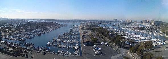
Marina del Rey is an unincorporated seaside community in Los Angeles County, California, with an eponymous harbor that is a major boating and water recreation destination of the greater Los Angeles area. The port is North America's largest man-made small-craft harbor and is home to approximately 5,000 boats. The area is a popular tourism destination for both land and water activities such as paddle board and kayak rentals, dining cruises, and yacht charters. Land activities include bicycling on several bicycle paths, walking paths along the waterfront, birdwatching. Wildlife watching opportunities include California sea lions and harbor seals. Dolphins and whales occasionally visit the deeper waters of harbor. This Westside locale is approximately 4 miles (6.4 km) south of Santa Monica, and 4 miles (6.4 km) north of Los Angeles International Airport.
Marina del Rey, California Marina del Rey | |
|---|---|
Unincorporated community Census-designated place | |
 Aerial view of Marina del Rey on takeoff from Los Angeles International Airport | |
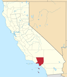
 Location within Los Angeles County | |
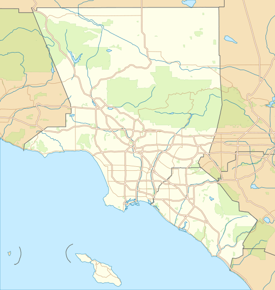 Marina del Rey Location within the Los Angeles metropolitan area  Marina del Rey Location within California  Marina del Rey Location within the United States | |
| Coordinates: 33°58′46″N 118°27′10″W | |
| Country | |
| State | |
| County | |
| Area | |
| • Total | 1.455 sq mi (3.768 km2) |
| • Land | 0.860 sq mi (2.226 km2) |
| • Water | 0.595 sq mi (1.541 km2) 40.91% |
| Elevation | 0 ft (0 m) |
| Population (2010) | |
| • Total | 8,866 |
| • Density | 6,100/sq mi (2,400/km2) |
| Time zone | UTC-8 (Pacific (PST)) |
| • Summer (DST) | UTC-7 (PDT) |
| ZIP codes | 90291–90292, 90295 |
| Area code | 310/424 |
| FIPS code | 06-45806 |
| GNIS feature ID | 1852255 |

The harbor is owned by Los Angeles County and managed by the Department of Beaches and Harbors (DBH). The Los Angeles Times said in a 1997 editorial that the harbor is "perhaps the county's most valuable resource".[3] The population was 8,866 at the 2010 census. For statistical purposes, the United States Census Bureau has defined Marina del Rey as a census-designated place (CDP).[4] The census definition of the area may not precisely correspond to local understanding of the area with the same name.
History
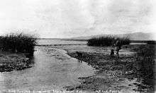
Prior to its development as a small craft harbor, the land occupied by Marina del Rey was a salt marsh fed by fresh water from Ballona Creek, frequented by duck hunters, including their hunting club, as well as by birdwatchers of the Los Angeles Audubon Society and the southern chapter of the Cooper Ornithological Club. Burton W. Chace, a former councilman of the City of Long Beach, who later became a member of the Los Angeles County Board of Supervisors, referred to the area as mud flats, though today the area would more properly be referred to as an estuary and wetland.
In the mid-19th century, Moye C. Wicks thought of turning this estuary and wetland of Playa del Rey into a commercial port.[5] He formed the Ballona Development Company in 1888 to develop the area, but three years later the company went bankrupt.
Port Ballona made by Louis Mesmer and Moye Wicks was then sold to Moses Sherman. Sherman purchased 1,000 acres (400 ha) of land around the Ballona lagoon and Port Ballona in 1902 under the name the Beach Land Company. Sherman and Clark renamed the land "Del Rey". Port Ballona was then renamed Playa Del Rey. The port was serviced by the California Central Railway opened in September 1887, this line later became the Santa Fe Railway, that later became the Atchison, Topeka, and Santa Fe Railroad. The rail line ran from the port to Redondo junction. A street car tram line was made to the Port by the Redondo and Hermosa Beach Railroad company, that had incorporated on February 21, 1901. This company was part of the Los Angeles Pacific Railroad owned by Sherman. The tram line opened December 1902 departed downtown at 4th & Broadway.[6][7]
In 1916, the U.S. Army Corps of Engineers revisited the idea of a commercial harbor, but declared it economically impractical. In 1936 the U.S. Congress ordered a re-evaluation of that determination, and the Army Corps of Engineers returned with a more favorable determination; however, the Marina del Rey harbor concept lost out to San Pedro as a commercial harbor and development funding went to the Port of Los Angeles instead.
In 1953, the Los Angeles County Board of Supervisors authorized a $2 million loan to fund construction of the marina. Since the loan only covered about half the cost, the U.S. Congress passed and President Dwight D. Eisenhower signed Public Law 780 making construction possible. Ground breaking began shortly after, during the early years of the of the John F. Kennedy administration.
With construction almost complete, the marina was put in danger in 1962–1963 due to a winter storm. The storm caused millions of dollars in damage to both the marina and the few small boats anchored there. A plan was put into effect to build a breakwater at the mouth of the marina, and the L.A. County Board of Supervisors appropriated $2.1 million to build it. On April 10, 1965, Marina del Rey was formally dedicated.[8] The total cost of the marina was $36.25 million for land, construction, and initial operation.
Los Angeles County then solicited bids for the harbor and port development, selling 60 year leaseholds to willing developers.[9][10] Real estate developer Abraham M. Lurie was the single largest leaseholder responsible for the building of three hotels, two apartment complexes, 1,000 boat slips, and several shopping centers, offices, restaurants; his holdings also included the last undeveloped piece of waterfront land in Marina del Rey.[10] He eventually ran into cash flow problems and sold a 49.9% interest to Saudi Arabian Sheik Abdul Aziz al Ibrahim, a brother of Waleed bin Ibrahim Al Ibrahim and a brother-in-law of King Fahd; the investment soon turned sour and following a protracted and aggressive lawsuit, in 1993 Lurie lost his entire interest in the development to Abdul Aziz.[11]
Geography
Marina del Rey falls within unincorporated Los Angeles County and is southeast of the L.A. City community of Venice and north of the L.A. City community of Playa del Rey, near the mouth of Ballona Creek. The harbor and port is located four miles (6 km) north of Los Angeles International Airport.
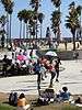
The harbor and the unincorporated residential and business community of Marina del Rey is bounded on all sides by the city of Los Angeles. The beach-style homes, on the inner portion of the coastal strand and the beach (see photo), west of the harbor, are within the city limits of Los Angeles, but share the same zip code as Marina del Rey. The name of this coastal strand that surrounds an estuarine inlet known as the Ballona Lagoon Marine Preserve is called the Marina Peninsula. The city street, Via Dolce, forms the boundary between Los Angeles and the unincorporated area of Los Angeles County, known as Marina del Rey.
According to the United States Census Bureau, Marina del Rey has an area of 1.5 square miles (3.9 km2). Nine-tenths of a square mile (2.2 km²) is land and 0.6 square miles (1.6 km2) is water (40.91%).
The specially designed harbor has many kinds of moorings with significant cement pilings for pleasure craft and large boats, including Catalina Island multi-passenger ferry boats, a large whale watching boat as well as a pelagic seabird watching boat, commercial fishing boats, harbor cruise ships, a U.S. Coast Guard Cutter Ship, LA County Fire Department and Sheriff Department boats, and is surrounded by high-rise condos, hotels, apartments, shops, and restaurants. The area also includes the University of Southern California Information Sciences Institute, the UCLA Marina Aquatic Center, and the Loyola Marymount University boathouse.
The community is served by the three-mile-long (5 km) Marina Freeway (State Route 90), which links Marina del Rey directly to Interstate 405 and nearby Culver City.
The area codes of Marina del Rey are 310 and 424. Its ZIP code is 90292.
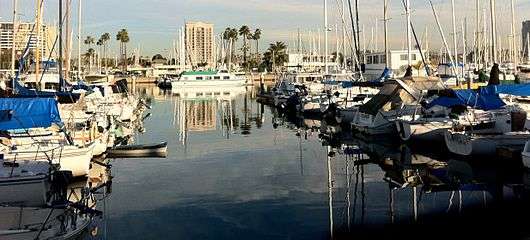 The marina from which Marina del Rey takes its name.
 Looking northeast from the South Jetty area of Marina del Rey on September 11, 2011.
Places adjacent to Marina del Rey, California | ||||||||||
|---|---|---|---|---|---|---|---|---|---|---|
| ||||||||||
Climate
| Climate data for Marina del Rey, California | |||||||||||||
|---|---|---|---|---|---|---|---|---|---|---|---|---|---|
| Month | Jan | Feb | Mar | Apr | May | Jun | Jul | Aug | Sep | Oct | Nov | Dec | Year |
| Average high °F (°C) | 67 (19) |
68 (20) |
69 (21) |
72 (22) |
73 (23) |
77 (25) |
80 (27) |
81 (27) |
80 (27) |
77 (25) |
71 (22) |
67 (19) |
74 (23) |
| Average low °F (°C) | 46 (8) |
47 (8) |
49 (9) |
52 (11) |
55 (13) |
58 (14) |
61 (16) |
62 (17) |
61 (16) |
57 (14) |
50 (10) |
46 (8) |
54 (12) |
| Average precipitation inches (mm) | 3.19 (81) |
3.25 (83) |
2.66 (68) |
0.58 (15) |
0.26 (6.6) |
0.04 (1.0) |
0.02 (0.51) |
0.07 (1.8) |
0.08 (2.0) |
0.33 (8.4) |
0.94 (24) |
1.90 (48) |
13.32 (338) |
| Source: IDcide[12] | |||||||||||||
Demographics
| Historical population | |||
|---|---|---|---|
| Census | Pop. | %± | |
| 1980 | 8,065 | — | |
| 1990 | 7,431 | −7.9% | |
| 2000 | 8,176 | 10.0% | |
| 2010 | 8,866 | 8.4% | |
| sources:[13][14] | |||
2010
The 2010 United States Census reported that Marina del Rey had a population of 8,866, of whom 80% are White (75% Non-Hispanic White),[15] 8% Asian, 8% Hispanic or Latino, and 5% African American. Marina del Rey had a median household income of $95,248, with 9.9% of the population living below the federal poverty line.[15][16]
Points of interest
- Ballona Wetlands
- California Yacht Club
- Fisherman's Village
- Lloyd Taber Marina del Rey Library
- Pacific Mariners Yacht Club
- UCLA Marina Aquatic Center
Parks and recreation
Marina del Rey has two main parks. Burton Chace Park hosts community festivals such as the Marina del Rey Summer Concert Series and the Marina del Rey Holiday Boat Parade.[17] Yvonne B. Burke Park was renamed from the original Admiralty Park in 2009 to honor long-time Los Angeles County Supervisor Yvonne Brathwaite Burke.[18]
Government
Marina del Rey is managed by the Los Angeles County Department of Beaches and Harbors.[19] All of the area's land is owned by the County of Los Angeles, which issues long-term leases.
Marina del Rey is in the Fourth District of the Los Angeles County Board of Supervisors, represented by Janice Hahn.
In the California State Legislature, Marina del Rey is in the 26th Senate District, represented by Democrat Ben Allen, and in the 62nd Assembly District, represented by Democrat Autumn Burke.[20]
In the United States House of Representatives, Marina del Rey is in California's 33rd congressional district, represented by Democrat Ted Lieu.[21]
Infrastructure
The Los Angeles County Sheriff's Department (LASD) has a substation in Marina del Rey. Prior to 1985, maritime and land law enforcement was provided by the Los Angeles County Harbor Patrol, a division of the Department of Small Craft Harbors. The Harbor Patrol was merged into the Sheriff's Department with sworn Harbor Patrol officers becoming Deputy Sheriffs.[22]
The Los Angeles County Fire Department (LACFD) serves Marina del Rey and is based at Station #110, a part of Battalion 1, at 4433 Admiralty Way.[23] The Los Angeles County Department of Health Services has an office in Marina del Rey.[24]
Transportation
The Marina Expressway, California State Route 90, terminates at Lincoln Blvd (California State Route 1) in northeastern Marina del Rey and links the area with Culver City. A water shuttle service, the WaterBus, operates on select days during the summer months. Shuttle services operate on the roads within the marina and between the nearby sites of Playa Vista, and the Venice Pier
Street layout
The harbor has eight basins separated by six strips of land, each of which has at least one street on it. From the northeastern end of the Marina, going clockwise, these streets are: Bali Way, Mindanao Way (with west terminus at Burton Chace Park), Fiji Way (bordering the southeastern edge of the Marina), Bora Bora Way, Tahiti Way, Marquesas Way, Panay Way, and Palawan Way. Panay Way, Marquesas Way, Tahiti Way, and Bora Bora Way are all on the western side of the Marina and all terminate at Via Marina. Palawan Way is also on the west side, but it terminates at Washington Bl.
Washington Boulevard bounds the Marina to the northwest. Palawan Way and Via Marina end to the north at Washington Blvd.
Education
Marina del Rey is in the Los Angeles Unified School District, although there are no schools in the area proper.[25] Students from Marina del Rey attend Coeur d'Alene Avenue Elementary School, Marina del Rey Middle School, and Venice High School.
Public libraries
The County of Los Angeles Public Library operates the Lloyd Taber-Marina del Rey Library. The library has a nautical collection to serve small boaters in the area.[26] The Abbot Kinney Memorial Branch of the Los Angeles Public Library is in Venice.[27]
Notable residents
- Sasha Gabor (1945–2008), actor[28]
References
- "2010 Census U.S. Gazetteer Files – Places – California". United States Census Bureau.
- "Marina del Rey". Geographic Names Information System. United States Geological Survey. Retrieved March 9, 2015.
- "Welcome Wave at the Marina". Editorial. Los Angeles Times. April 17, 1997.
- "Marina del Rey Census Designated Place". Geographic Names Information System. United States Geological Survey.
- GARNER, SCOTT (August 25, 2016). "Neighborhood Spotlight: Marina del Rey sets a course for a comeback". Los Angeles Times. Retrieved August 17, 2018.
- "Los Angeles Pacific Corporate Histories". www.erha.org.
- delreync.org, Del Rey Neighborhood Council, Marina Del Rey History Archived July 14, 2014, at the Wayback Machine
- Los Angeles Times: "Marina del Rey Development Rose Out of Mud (First Of Two Parts) November 12, 1989
- The Argonaut: "Former Prominent Marina Del Rey Developer Abraham Lurie Dies at 86" July 8, 2010
- Los Angeles Times: "Biggest Marina Developer Files for Bankruptcy : Finances: Abraham M. Lurie seeks court protection as he battles his Saudi partners for control of his extensive holdings" by Jeffrey L. Rabin June 13, 1991
- Los Angeles Times: "Saudi Wins Court Fight Over Marina : Real estate: Billionaire gains control of nearly 20% of county-owned Marina del Rey. Ruling ends Abraham Lurie's involvement" by Jeffrey L. Rabin and Ron Russell May 01, 1993
- "Marina del Rey, CA Normal Temperatures and Precipitation". Retrieved January 15, 2011.
- "CENSUS OF POPULATION AND HOUSING (1790-2000)". U.S. Census Bureau. Retrieved July 17, 2010.
- United States Census US Census Bureau
- "Marina del Rey CDP, California". Archived from the original on July 1, 2012.
- "2010 Census Interactive Population Search: CA - Marina del Rey CDP". U.S. Census Bureau. Archived from the original on July 15, 2014. Retrieved July 12, 2014.
- "Burton W. Chase Park Archived August 4, 2009, at the Wayback Machine". County of Los Angeles. Retrieved on March 22, 2010.
- "Yvonne B. Burke Park Archived April 13, 2010, at the Wayback Machine". County of Los Angeles. Retrieved on March 22, 2010.
- Los Angeles County Department of Beaches and Harbors Archived March 1, 2009, at the Wayback Machine.
- "Statewide Database". UC Regents. Archived from the original on February 1, 2015. Retrieved December 15, 2014.
- "California's 33rd Congressional District - Representatives & District Map". Civic Impulse, LLC.
- "Marina del Rey Station Archived January 21, 2010, at the Wayback Machine". Los Angeles County Sheriff's Department. Retrieved on January 21, 2010.
- "Hometown Fire Stations Archived September 3, 2011, at the Wayback Machine". Los Angeles County Fire Department. Retrieved on December 6, 2008.
- "About Us". Los Angeles County Department of Health Services. Retrieved on March 18, 2010.
- Board District 4 Map. Los Angeles Unified School District. Retrieved on November 24, 2008.
- "Lloyd Taber-Marina del Rey Library". County of Los Angeles Public Library. Retrieved on December 6, 2008.
- "Venice - Abbot Kinney Memorial Branch Library | Los Angeles Public Library". www.lapl.org. Retrieved February 9, 2018.
- Warren, Peter. "Ron Jeremy Remembers Sasha Gabor AVN". AVN. Archived from the original on July 11, 2019. Retrieved January 18, 2020.
External links
| Wikimedia Commons has media related to Marina del Rey, California. |
| Wikivoyage has a travel guide for Marina del Rey. |
- LA County Dept. of Beaches and Harbors: Marina del Rey homepage
- LA County Dept. of Beaches and Harbors: Recreational activities in Marina del Rey
Westside region, Los Angeles | ||
|---|---|---|
| Districts and neighborhoods |
|  |
| Points of interest | ||
| Neighboring cities and communities | ||

| Authority control |
|
|---|