Maywood, California
Maywood is a small Gateway city in Los Angeles County.[8] At 1.18 square miles (3.1 km2),[9] Maywood is the third-smallest incorporated city in Los Angeles County.[10] It is bordered by the cities of Bell on the south, Vernon on the north and west, Huntington Park on the southwest, and Commerce on the east. It is the most densely-populated city in California, and has the highest proportion of Latinos, immigrants, and undocumented immigrants in the county.
Maywood, California | |
|---|---|
City | |
| City of Maywood | |
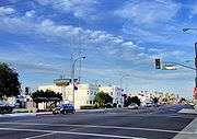
 Images, from top, left to right: Slauson Ave, Swimming Pool, Retirement Home, Maywood High School | |
 Seal | |
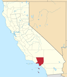
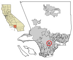 Location of Maywood in Los Angeles County, California | |
 Maywood Location within the Greater Los Angeles  Maywood Location within California  Maywood Location in the United States | |
| Coordinates: 33°59′16″N 118°11′12″W | |
| Country | |
| State | |
| County | |
| Incorporated | September 2, 1924[1] |
| Government | |
| • Mayor | Eddie De La Riva[2] |
| • City Council | Heber Marquez Ricardo Lara Ramon Medina |
| Area | |
| • Total | 1.18 sq mi (3.05 km2) |
| • Land | 1.18 sq mi (3.05 km2) |
| • Water | 0.00 sq mi (0.00 km2) 0% |
| Elevation | 151 ft (46 m) |
| Population (2010) | |
| • Total | 27,395 |
| • Estimate (2019)[5] | 26,973 |
| • Density | 23,457.56/sq mi (9,053.77/km2) |
| Time zone | UTC-8 (PST) |
| • Summer (DST) | UTC-7 (PDT) |
| ZIP Code | 90270[6] |
| Area code(s) | 213 / 323 [7] |
| FIPS code | 06-46492 |
| GNIS feature ID | 1661000 |
| Website | www |
As of July 1, 2010, Maywood became the first municipality in California to outsource all of its city services,[11][12][13] dismantling its police department, laying off all city employees except for the city manager, city attorney and elected officials,[12] and contracting with outside agencies for the provision of all municipal services.[14] The population was 27,395 at the 2010 census.
History
The land on which Maywood now stands had been populated by Native American tribes for centuries. The area that would later become Maywood was deeded in 1781 by the Spanish monarchy to Spanish War veteran Manuel Nieto. When the settlement of Pueblo de Nuestra Senora de Los Angeles was recorded, it included the cow pasture (now Maywood) that eventually turned into a rancho.[15]
In 1919, May Wood, a popular young woman who worked for the real estate corporation developing the 2,300 acres (930 hectares) ranch into home tracts, agreed to lend her name to the property. The development of Maywood later survived a bitter challenge to dissolve the prospective city in early 1924.[16]
On September 2, 1924, Maywood's citizens voted to incorporate and about 300 people turned out for the dedication, including Miss May Wood. By 1924, the population of Maywood had reached 1,000. The city featured homes, stores and a movie theater. In the 1930s, gamblers were successfully removed from the city. Maywood Parks and Recreation built Maywood Park, had its beginnings in the 1930s, when a large meadow was turned into the present day baseball field. The Golden State Baseball Association made Maywood Park its home in the early 1950s.
The Chrysler Corporation had an auto assembly plant in Maywood from the 1920s until its closing in July 1971. It was located at 5800 Eastern Avenue at Slauson, and was generally referred to as the "Los Angeles" Plant.[17] When the city of Commerce was incorporated in 1961, that corner was annexed as were several in the surrounding area.[18]
Maywood Assembly was a Ford Motor Company assembly plant also located in Maywood, that operated from 1948 until 1957. The address was 5801 S. Eastern Avenue, and it was across the street from the Chrysler Assembly factory, and exclusively built Lincoln and Mercury vehicles. The factory was closed and demolished when operations at Maywood and Long Beach were combined into a new factory in Pico Rivera in 1958.

Willys-Overland built its California factory in Maywood, California, in 1929 at the current location of 6201 Randolph Street.[19] Over 900 people were employed at the new $1.5 million assembly plant. Willys-Overland became the second automobile manufacturer to build a major plant in the city. After the United States entered World War II, automobile production for civilians was phased out and in November 1941, automobile assembly at Maywood was stopped. A great many automobile plants were retooled to manufacture war machinery and for three years during the war, the Lockheed Aircraft Corporation rented the plant building from Willys-Overland for that purpose. Equipment was installed for the manufacture of sub-assemblies for Hudson Bombers [20] until the war ended. Willys-Overland began to manufacture the first Jeeps (CJ-2As) for civilians in 1945. As the demand for Jeeps increased, the reconditioning of the plant back to automobile assembly began early in 1947 and by November, Willys was building "West Coast" CJ-2As. By the end of November, 108 Jeeps had been assembled.[21] Jeep Trucks and Station Wagons were incorporated into the West Coast Division's "final assemblies" production lines in 1948. The Maywood plant produced the entire CJ-3A model production duration and about 5% of all CJ-3As were assembled in California. In 1952, Willys-Overland introduced a new post-war model car, the Aero, and they were assembled in both Maywood and Toledo. The entire plant was shut down in 1954.[20]
2010 city layoffs
Maywood officials were given notice in June 2009,[22] that the city would lose its insurance coverage unless they implemented a 20-point performance plan. Maywood also owed the California Insurance Authority $927,135 and had been making interest-only payments. Mainly because of the troubled history, including multiple lawsuits, and the dubious reputation of the Maywood Police Department,[23] the city's Liability and Workers Compensation insurer, notified the city in August 2009, that it would cancel its coverage effective July 1, 2010. When the city was unable to find coverage elsewhere, it disbanded its police department, laid off all city employees, except for the city manager, city attorney and elected officials, and contracted with other agencies to provide all municipal services.[14][24]
An outside audit found that Maywood was losing approximately $620,000 annually from its $10 million general fund budget [14] under the previous seven-year contract with nearby Cudahy,[12] because they had neglected to bill Cudahy for administration, vehicle maintenance or insurance. The firm concluded that Maywood was losing about $620,000 a year, or a total of about $4 million in the last six years.[25] George Perez, Cudahy's city manager, said Maywood's "politics have been getting in the way." Perez said that he and then-acting Maywood City Manager, Paul Philips would agree on a new contract, but the Maywood City Council would then send Philips back for further negotiation. Perez said that negotiations disintegrated in February, after Philips resigned.[22]

Councilman Felipe Aguirre said, "We don't want to file for bankruptcy. We don't want to disappear as a city." Aguirre said filing for bankruptcy was not an option for Maywood because its problems were related specifically to insurance coverage.[14] Several cities in the state have said that they are close to bankruptcy because of the sharp drop in sales and property tax revenues caused by the deepest recession in decades.[14] During a heated City Council meeting in June 2010, opponents of the plan accused council members of mismanaging the city by failing to maintain insurance coverage.[14] Under the plan adopted by the City Council that night, council members would continue to be paid to set policy, but all services would be contracted out. "You single-handedly destroyed the city," Lizeth Sandoval, the city treasurer, told the City Council. Sandoval, a city employee spoke out as a private citizen, and was laid off as part of the cuts.[14][26]
Though Maywood officials stopped short of filing for bankruptcy or even giving up the city's municipal status, the city still faces a serious problem with a huge deficit.[27] The city did keep a few employees as independent contractors when they outsourced most city functions to Bell and police duties to the Los Angeles County Sheriff's Department.[24] In September 2010, the troubled nearby city of Bell agreed to cancel the contract to handle the day-to-day operations of neighboring Maywood.[28] Maywood has been overrun with political crises—from recalls to a city clerk accused of trying to contract a hit man to kill Councilman Aguirre. In early 2006, a newly elected Aguirre called Maywood a "sanctuary city" for illegal immigrants,[24] stating: "I think we needed to amplify the debate by saying that no human being is illegal. These people are here ... making your clothes, shining your shoes and taking care of your kids. And now you want to develop this hypocritical policy?"[29] "Maywood's actions have made the town a lightning rod for criticism on conservative radio shows and websites."[29]
Geography
Maywood is located at 33°59′16″N 118°11′12″W (33.987864, -118.186553).[30] According to the United States Census Bureau, the city has a total area of 1.2 square miles (3.1 km2), all land.
It is 8 miles (13 km) southeast from Downtown Los Angeles Financial District and only 2 miles (3.2 km) east of the Los Angeles city limit on Slauson Ave and Alameda St in the Central-Alameda neighborhood.[31] Maywood is part of the Gateway Cities region of southeastern Los Angeles County area. Maywood is bordered by the city of Bell on the south, Vernon on the north and west, Huntington Park on the southwest, and Commerce on the east.
Climate
The climate in the city of Maywood is very warm during summer when high temperatures tend to be in the 80s and mild during winter when high temperatures tend to be in the 60s.[9] The warmest month of the year is August with an average maximum temperature of 89.40 °F (31.89 °C), while the coldest month of the year is December with an average minimum temperature of 47.30 °F (8.50 °C).[32] Temperature variations between night and day tend to be moderate during summer with a difference that can reach 24 °F (13.3 °C), and moderate during winter with an average difference of 22 °F (12.2 °C). The annual average precipitation at Maywood is 15.07 inches (383 mm). The wettest month of the year is February with an average rainfall of 3.75 inches (95 mm).[33] Maywood-area historical tornado activity is significantly above California state average. It is 75% smaller than the overall U.S. average. On November 7, 1966, a category 2 (max. wind speeds 113-157 mph) tornado 6.2 miles (10.0 km) away from the Maywood city center injured 10 people and caused between $50,000 and $500,000 in damages.[34]
Demographics
| Historical population | |||
|---|---|---|---|
| Census | Pop. | %± | |
| 1930 | 6,794 | — | |
| 1940 | 10,731 | 57.9% | |
| 1950 | 13,292 | 23.9% | |
| 1960 | 14,588 | 9.8% | |
| 1970 | 16,996 | 16.5% | |
| 1980 | 21,810 | 28.3% | |
| 1990 | 27,850 | 27.7% | |
| 2000 | 28,083 | 0.8% | |
| 2010 | 27,395 | −2.4% | |
| Est. 2019 | 26,973 | [5] | −1.5% |
| U.S. Decennial Census[35] | |||
2010
The 2010 United States Census[36] reported that Maywood had a population of 27,395. The population density was 23,247.5 people per square mile (8,975.9/km2). The racial makeup of Maywood was 14,244 (52.0%) White (1.8% Non-Hispanic White),[37] 166 (0.6%) African American, 208 (0.8%) Native American, 87 (0.3%) Asian, 20 (0.1%) Pacific Islander, 11,495 (42.0%) from other races, and 1,175 (4.3%) from two or more races. Hispanic or Latino of any race were 26,696 persons (97.4%).
The Census reported that 27,276 people (99.6% of the population) lived in households, 0 (0%) lived in non-institutionalized group quarters, and 119 (0.4%) were institutionalized.
There were 6,559 households, out of which 4,120 (62.8%) had children under the age of 18 living in them, 3,721 (56.7%) were opposite-sex married couples living together, 1,254 (19.1%) had a female householder with no husband present, 717 (10.9%) had a male householder with no wife present. There were 595 (9.1%) unmarried opposite-sex partnerships, and 32 (0.5%) same-sex married couples or partnerships. 599 households (9.1%) were made up of individuals, and 231 (3.5%) had someone living alone who was 65 years of age or older. The average household size was 4.16. There were 5,692 families (86.8% of all households); the average family size was 4.30.
The population was spread out, with 8,925 people (32.6%) under the age of 18, 3,402 people (12.4%) aged 18 to 24, 8,619 people (31.5%) aged 25 to 44, 4,807 people (17.5%) aged 45 to 64, and 1,642 people (6.0%) who were 65 years of age or older. The median age was 27.9 years. For every 100 females, there were 104.5 males. For every 100 females age 18 and over, there were 102.9 males.
There were 6,766 housing units at an average density of 5,741.6 per square mile (2,216.9/km2), of which 1,980 (30.2%) were owner-occupied, and 4,579 (69.8%) were occupied by renters. The homeowner vacancy rate was 1.2%; the rental vacancy rate was 2.6%. 9,245 people (33.7% of the population) lived in owner-occupied housing units and 18,031 people (65.8%) lived in rental housing units.
According to the 2010 United States Census, Maywood had a median household income of $37,114, with 28.3% of the population living below the federal poverty line.[38]
2000
As of the census[39] of 2000, there were 28,083 people, 6,469 households, and 5,699 families residing in the city. The population density was 23,887.2 inhabitants per square mile (9,188.9/km2). There were 6,701 housing units at an average density of 5,699.8 per square mile (2,192.6/km2). The racial makeup of the city was 42.99% White, 0.36% African American, 1.14% Native American, 0.36% Asian, 0.13% Pacific Islander, 50.48% from other races, and 4.53% from two or more races. Hispanic or Latino of any race were 96.33% of the population.
There were 6,469 households, out of which 62.9% had children under the age of 18 living with them, 60.8% were married couples living together, 16.9% had a female householder with no husband present, and 11.9% were non-families. 8.4% of all households were made up of individuals, and 3.2% had someone living alone who was 65 years of age or older. The average household size was 4.33 and the average family size was 4.47.
In the city, the population was varied, with 37.0% under the age of 18, 13.2% from 18 to 24, 32.6% from 25 to 44, 13.0% from 45 to 64, and 4.2% who were 65 years of age or older. The median age was 25 years. For every 100 females, there were 104.1 males. For every 100 females age 18 and over, there were 105.4 males.
The median income for a household in the city was $30,480, and the median income for a family was $30,361. Males had a median income of $20,646 versus $16,397 for females. The per capita income for the city was $11,935.[40] About 23.1% of families and 24.5% of the population were below the poverty line, including 29.3% of those under age 18 and 11.7% of those age 65 or over.
Immigrant population
Several news accounts have said Maywood's official population reaches approximately 40,000 persons when illegal aliens are counted. A significant percentage of its residents work in the factories at nearby Vernon and Commerce.[41] The city has been at the forefront of immigration debates. It is speculated that one- third of Maywood's residents population lives in the U.S. without documentation.[42] The city, 96% of which is Latino, and more than half are foreign-born, has declared itself as a "Sanctuary City" for illegal immigrants.[42]
Latino communities
These were the ten cities or neighborhoods in Los Angeles County with the largest percentage of Latino residents, according to the 2000 census:[43]
- East Los Angeles, California, 96.7%
- Maywood, California, 96.4%
- City Terrace, California, 94.4%
- Huntington Park, California, 95.1%
- Boyle Heights, Los Angeles, 94.0%
- Cudahy, California, 93.8%
- Bell Gardens, California, 93.7%
- Commerce, California 93.4%
- Vernon, California, 92.6%
- South Gate, California, 92.1%
High-density neighborhoods
These were the ten neighborhoods or cities in Los Angeles County with the highest population densities, according to the 2000 census, with the population per square mile:[44]
- Koreatown, Los Angeles, 42,611
- Westlake, Los Angeles, 38,214
- East Hollywood, Los Angeles, 31,095
- Pico-Union, Los Angeles, 25,352
- Maywood, California, 23,638
- Harvard Heights, Los Angeles, 23,473
- Hollywood, Los Angeles, 22,193
- Walnut Park, California, 22,028
- Palms, Los Angeles, 21,870
- Adams-Normandie, Los Angeles, 21,848
Government
Municipal government
Maywood City Hall is located at 4319 E Slauson Avenue. The current council consists of Mayor Eddie De La Riva, Mayor Pro Tempore Ricardo Lara, Councilman Ramon Medina, Councilman Carlos Alvarez, and Councilman Heber Marquez. The City of Maywood has Jennifer Vasquez as full-time City Manager.
County, state, and federal representation
L.A. County Supervisor Hilda Solis represents Maywood.
In the California State Legislature, Maywood is in the 33rd Senate District, represented by Democrat Lena Gonzalez, and in the 63rd Assembly District, represented by Democrat Anthony Rendon.[45]
In the United States House of Representatives, Maywood is in California's 40th congressional district, represented by Democrat Lucille Roybal-Allard.[46]
Infrastructure
Due to financial crisis the city officials in Maywood disbanded the Maywood Police Department and contracted with the Los Angeles County Sheriff's Department for law enforcement services. In August 2010, the Sheriff's Department went out walking in Maywood streets and knocking on residents' doors to survey the safety and policing needs in the community. The nearby East Los Angeles Sheriff's Station will address non-emergency police questions and concerns including requests for police reports.[47]
Fire protection in Maywood is provided by the Los Angeles County Fire Department. Ambulance transport is provided by Care Ambulance Service. The Los Angeles County Sheriff's Department will continue to provide police and aerial support to the city of Maywood.[48]
The Los Angeles County Department of Health Services operates the Whittier Health Center in Whittier, serving Maywood.[49]

The United States Postal Service Maywood Post Office is located at 4357 Slauson Avenue.[50]
Transportation
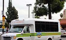
The city can be reached by Atlantic Boulevard which runs north and south through the city and Slauson Avenue which runs east and west through the city. Maywood is also accessible via the Interstate 710 on Atlantic Boulevard. Los Angeles County Metropolitan Transportation Authority (Metro) provides bus services to the city, Metro Local Line 108 and Metro Rapid Line 358 on Slauson Avenue.[51] Metro Local Line 260[52] and Metro Rapid Line 762[53] on Atlantic Boulevard. Metro Shuttle Line 611 runs through the westside and northside of the city.[54]
The city of Maywood also operates a local bus service to its residents called Dial-a-Ride. The shuttles pick up residents at their location and transports them within the city limits for a one way fee of $1.00. The service is free to senior citizens, age 62 and over, and handicapped individuals. Seniors and the handicapped must come to City Hall to pick up their free pass. Effective January 2, 2013, the City of Maywood will no longer provide Dial-A-Ride service to the general public. Dial-A-Ride service will only be available to City of Maywood residents 62 years and over or those with a physician-certified disability which prohibits the use of public transportation. Individuals requiring special assistance will be permitted to have an attendant accompany them.[55]
Education
K–12 schools
Maywood is a part of the Los Angeles Unified School District. The city has also joined South Gate, Huntington Park, Cudahy, Vernon, and Bell in the Southeast Cities School Coalition to improve the education of the children of the Southeast.[56] Several council members from each city are part of this group. The city is offering scholarships to students planning to attend Community Colleges and Universities. This may change with the city reorganization.
.JPG)
Public primary schools
Maywood is served by several public elementary schools, including:
- Fishburn Avenue Elementary School (Maywood)
- Heliotrope Elementary School (Maywood)
- Loma Vista Elementary School (Maywood)
- Maywood Elementary School (Maywood) (opened 2005[57])
- Clemente Charter School (co-located at Fishburn Ave. ES and Heliotrope ES) - opened 2014
- Nueva Vista Elementary School (Bell)
Public middle schools
Maywood is served by several public middle schools, including:
- Nimitz Middle School (Huntington Park)
- South Region MS #2 (Bell) Opened September 2010
Public secondary schools
Maywood is served by several public secondary schools, including:
- Bell High School (Bell)
- Huntington Park High School (Huntington Park)
- Maywood Academy High School (Maywood)
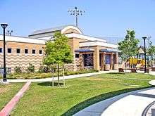
Most of Maywood is zoned to Bell High School, while a portion is zoned jointly to Bell and Huntington Park high schools.[58][59] Any student who lives in the Bell or Huntington Park zones may apply to Maywood Academy High School; Maywood Academy, which opened in 2005 and moved into its permanent campus in 2006, does not have its own attendance boundary because it lacks American football, track and field, and tennis facilities.[60] Maywood Academy is a showcase "green" school in the Los Angeles Unified School District (LAUSD). In the time since its opening, it has made the case that, aside from reducing environmental impact, sustainable design can dramatically improve a school's learning environment, and hopefully, even its attendance rates. Data is being gathered; it is too soon to demonstrate that this "green school" is fulfilling its goals.[61]
In November 2009, the voters in Maywood, in an advisory vote, voted against the acquisition and demolition of properties to build a new high school. The construction of the new school would demolish the homes of over 200 families in Maywood.[62] The voters also voted to have more studies to find an alternative site for the school.[63]
Private schools
Private schools include Maywood Christian School (K–12), an independent private school,[64] Betania Christian School (1-12), an independent private school,[65] and St. Rose of Lima School (K-8) of the Roman Catholic Archdiocese of Los Angeles.[66]
Parks and recreation
Maywood has two major parks and two small "pocket parks". The existing Maywood Park at 4801 E 58th Street and the new Maywood Riverfront Park at 5000 Slauson Avenue are currently the largest parks in the city, both are in the east side of the city. Maywood Park has a baseball field and the Maywood Activity Center, which opened in 1999. The Parks and Recreation Department currently maintains all of the parks in the city and offers many activities for all ages, seniors, adults and youth. Mr. Aldo Perez is Director of Parks and Recreation. The two pocket parks are Pixely Park and Pine Avenue Park.[27]
The Maywood Activities Center (M.A.C.), is available for general public use and offers a wide variety of classes, specialty rooms, indoor basketball court, gymnasium, pool and place for clubs and classes to meet.[67]
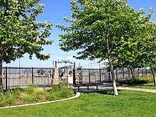
The new Riverfront Park is located next to the Los Angeles River and has handball courts, a basketball court, and soccer field. It also includes an access pathway to the LA River Bike Path that travels through 40 miles (64 km) of Los Angeles County, including Griffith Park and Long Beach A small pocket park is located in the west side of the city, Pixley Park at 3626 56th Street. Two small pocket parks were proposed to the city in 2008, Maywood Avenue Park and Pine Avenue Park are to be built in the future in the west side of the city. As the city reorganizes, future plans are on hold.
The only sports team located in the city is the Maywood Buzz, which features former NBA star Cedric Ceballos. The team plays in the Maywood Activities Center, also known as the M.A.C. They are an ABA (American Basketball Association) team. Several famous baseball players have played at Maywood Park including former MLB player Marvin Benard, who attended local rival, Bell High School.[68]
The ABA team, the Beijing Aoshen Olympians played their inaugural season at the M.A.C. during the 2005–2006 season. They reached the playoffs, but lost to the SoCal Legends in the Great Eight Tournament in Rochester. After the season, the Olympians relocated, and now play on the campus of Azusa Pacific University.
"Maywood Street Fair"


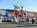
Every Memorial Day weekend the City of Maywood holds their annual Street Fair.[69] It is a place where families, friends, and neighbors get together to experience a variety of food, music, games, raffles, rides, and multi-cultural activities. Street fair presale ride tickets will be available at City Hall until sold out. Location : On Slauson between Pine Avenue and Loma Vista Avenue [70] In July 2010, over 600 people attended the First Annual 4 July Family Fun Day Celebration at the Maywood Activities Center, to honor the country's declaration of independence.[47] For a couple of years the fair did not return until recently.
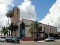
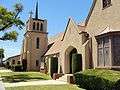
Places of worship
|
First Baptist Church
Maywood Apostolic Christian Church
Maywood Church of the Nazarene
Maywood United Methodist Church
Saint Rose of Lima Catholic Church
Iglesia Betania
Bab UL Lim Islamic
Zion Lutheran Church
Church of Jesus Christ of Latter Day Saints
|
|


Notable people
- Larry Anderson - professional baseball player, 1972–75, pitched for both the Chicago White Sox and the Milwaukee Brewers
- Tom Araya - bassist and vocalist for the band Slayer
- Scott Autrey - professional motorcycle speedway racer, part of the USA team that won the 1982 Speedway World Team Cup
- Jack Brohamer - former professional baseball player, played for both Cleveland and Boston in a career that spanned from 1972–1982; in 1977 he hit for the cycle
- Todd Burns - former professional baseball player for the Oakland Athletics
- Jim Messina - songwriter, singer, guitarist, recording engineer, and record producer; half of rock duo Loggins and Messina
- Dana Plato - actress, best known as Kimberly Drummond on Diff'rent Strokes (1978-1986)
- Christie Repasy - American floral artist
- Ed Roth - American hot rod builder, fabricator, enthusiast
- Robert S. Woods - actor, played character Bo Buchanan on the ABC daytime drama "One Life To Live"
See also
References
- "California Cities by Incorporation Date". California Association of Local Agency Formation Commissions. Archived from the original (Word) on November 3, 2014. Retrieved August 25, 2014.
- "Maywood City Council". City of Maywood, California. Retrieved November 18, 2014.
- "2016 U.S. Gazetteer Files". United States Census Bureau. Retrieved June 28, 2017.
- "Maywood". Geographic Names Information System. United States Geological Survey. Retrieved October 17, 2014.
- "Population and Housing Unit Estimates". Retrieved May 21, 2020.
- "USPS - ZIP Code Lookup - Find a ZIP+ 4 Code By City Results". Retrieved January 18, 2007.
- "Number Administration System - NPA and City/Town Search Results". Archived from the original on September 29, 2007. Retrieved January 18, 2007.
- Luhby, Tami (July 1, 2010). "Maywood, California, lays off all employees - July 1, 2010". Money.cnn.com. Retrieved August 17, 2010.
- "City History & Facts". Cityofmaywood.com. September 2, 1924. Archived from the original on July 8, 2011. Retrieved August 17, 2010.
- "www.maywoodcalifornia.us". www.maywoodcalifornia.us. July 22, 2010. Archived from the original on September 19, 2017. Retrieved August 17, 2010.
- "Municipal finances: There goes everybody". The Economist. July 8, 2010. Retrieved February 25, 2019.
- Tami Luhby, senior writer (July 1, 2010). "Maywood, California, lays off all employees". Finance.yahoo.com. Archived from the original on July 5, 2010. Retrieved August 17, 2010.
- Palmeri, Christopher (August 3, 2010). "California City That Outsourced Everyone Is Snared by Pay Scandal in Bell". Bloomberg. Retrieved August 17, 2010.
- Ruben Vives, Jeff Gottlieb and Hector Becerra (June 23, 2010). "Maywood to hire others to run the city". Los Angeles Times. Retrieved July 18, 2010.
- Ahrens, Edward A. "City of Maywood" pg. 1
- Ahrens, Edward A., "City of Maywood"
- Davis, Michael W.R. (2001). Chrysler Heritage: A Photographic History. ISBN 978-0-7385-0779-8. Retrieved July 19, 2010.
- "Books". Varley.net. July 23, 2007. Retrieved August 17, 2010.
- "Factories and dealerships of historical Los Angeles at Hemmings Blog—Classic and collectible cars and parts". Blog.hemmings.com. Retrieved August 17, 2010.
- "The Maywood Assembly Plant". Cj3a.info. Retrieved August 17, 2010.
- Toledo Times
- Jeff Gottlieb and Ruben Vives (June 25, 2010). "Maywood didn't meet insurer's conditions". Los Angeles Times. Retrieved July 19, 2010.
- Matt Lait and Scott Glover (April 1, 2007). "Maywood employs police officers with a history of trouble". Los Angeles Times. Retrieved July 19, 2010.
- Becerra, Hector (August 10, 2010). "Bell salary scandal: Maywood leaders may try to fire Bell". latimes.com. Retrieved August 17, 2010.
- "Cudahy to contract with the Sheriff's Department | L.A. NOW | Los Angeles Times". Latimesblogs.latimes.com. June 25, 2010. Retrieved August 17, 2010.
- "Maywood (Los Angeles, California): Maywood (Los Angeles, California) News and Photos". chicagotribune.com. Retrieved August 17, 2010.
- "City of Maywood". City of Maywood. Retrieved August 17, 2010.
- "Bell Fallout news in Maywood, California | Outside.in local topics". Archived from the original on July 21, 2011. Retrieved September 30, 2010.
- Becerra, Hector (March 21, 2006). "Welcome to Maywood, Where Roads Open Up for Immigrants". Los Angeles Times. Retrieved February 27, 2019.
- "US Gazetteer files: 2010, 2000, and 1990". United States Census Bureau. February 12, 2011. Retrieved April 23, 2011.
- "Central-Alameda". Mapping L.A.
- "Maywood, California (CA 90270) profile: population, maps, real estate, averages, homes, statistics, relocation, travel, jobs, hospitals, schools, crime, moving, houses, sex offenders, news, sex offenders". City-data.com. Retrieved August 30, 2010.
- "Maywood Weather - Maywood CA - Conditions, Forecast, Average". www.idcide.com.
- "Maywood, California (CA 90270) profile: population, maps, real estate, averages, homes, statistics, relocation, travel, jobs, hospitals, schools, crime, moving, houses, sex offenders, news, sex offenders". City-data.com. Retrieved August 30, 2010.
- "Census of Population and Housing". Census.gov. Retrieved June 4, 2015.
- "2010 Census Interactive Population Search: CA - Maywood city". U.S. Census Bureau. Archived from the original on July 15, 2014. Retrieved July 12, 2014.
- "Archived copy". Archived from the original on September 6, 2013. Retrieved September 7, 2013.CS1 maint: archived copy as title (link)
- "State & County QuickFacts; Maywood (city), California". June 27, 2013. Archived from the original on September 6, 2013.
- "U.S. Census website". United States Census Bureau. Retrieved January 31, 2008.
- "Maywood, California (CA 90270) profile: population, maps, real estate, averages, homes, statistics, relocation, travel, jobs, hospitals, schools, crime, moving, houses, sex offenders, news, sex offenders". City-data.com. Retrieved August 17, 2010.
- https://www.census.gov factfinder.census.gov
- "Sanctuary for illegal immigrants - NBC News tv - The Ed Show - NBC News". NBC News. March 27, 2006. Retrieved August 17, 2010.
- "Latino" Mapping L.A., Los Angeles Times
- "Population Density". Los Angeles Times. Mapping L.A. Retrieved June 12, 2016.
- "Statewide Database". UC Regents. Archived from the original on February 1, 2015. Retrieved December 14, 2014.
- "California's 40th Congressional District - Representatives & District Map". Civic Impulse, LLC.
- "City of Maywood". City of Maywood. Retrieved August 30, 2010.
- "Fire Services". Cityofmaywood.com. Archived from the original on May 3, 2011. Retrieved August 30, 2010.
- "Whittier Health Center Archived May 27, 2010, at the Wayback Machine." Los Angeles County Department of Health Services. Retrieved on March 18, 2010.
- "Post Office Location - MAYWOOD." United States Postal Service. Retrieved on December 6, 2008.
- "Metro Line 108/358" (PDF).
- "Metro Local Line 260" (PDF). Archived from the original (PDF) on June 26, 2010. Retrieved February 25, 2010.
- "Metro Rapid 762" (PDF).
- "Metro Shuttle 611" (PDF).
- "Maywood Dial-a-Ride Service". Archived from the original on July 8, 2011. Retrieved February 25, 2010.
- "Southeast Cities Schools Coalition". Archived from the original on April 25, 2011. Retrieved February 25, 2010.
- http://www.laschools.org/project-status/one-project?project_number=55.98005 laschools.org
- "Proposed Changes to South East HS Area Schools." Los Angeles Unified School District. Retrieved on June 24, 2010.
- "Maywood city, California Archived June 7, 2011, at the Wayback Machine." U.S. Census Bureau. Retrieved on July 2, 2010.
- "School History Archived November 24, 2010, at the Wayback Machine." Maywood Academy High School. Retrieved on July 2, 2010.
- "Green Technology News". Green-technology.org. Archived from the original on December 7, 2010. Retrieved August 30, 2010.
- "Annexation of City of Maywood properties by LAUSD, Measure MS, November 2009". Ballotpedia. Retrieved August 30, 2010.
- "City of Maywood Alternate LAUSD School Site Selection, Measure SC, November 2009". Ballotpedia. Retrieved August 30, 2010.
- "Welcome to Maywood Christian School Archived October 9, 2009, at the Wayback Machine." Maywood Christian School. Retrieved on December 6, 2008.
- "Betania Christian School." Betania Christian School. Retrieved on December 6, 2008.
- "St. Rose of Lima School Archived May 26, 2011, at the Wayback Machine." Roman Catholic Archdiocese of Los Angeles. Retrieved on December 6, 2008.
- Maywood Parks & Recreation Description "Archived copy". Archived from the original on May 3, 2011. Retrieved February 24, 2010.CS1 maint: archived copy as title (link). Retrieved 2-24-10.
- "Marvin Benard Statistics and History". Baseball-Reference.com. Retrieved August 30, 2010.
- "Maywood Street Fair". Cityofmaywood.com. Archived from the original on July 8, 2011. Retrieved August 30, 2010.
- "Street Fair - Labor Day Weekend". Cityofmaywood.com. Archived from the original on July 8, 2011. Retrieved August 17, 2010.
External links
| Wikimedia Commons has media related to Maywood, California. |
- Maywood official website
- Maywood Local 24-Hour Weather
- Profile on Maywood Academy High School
- Maywood First Baptist Church
- Maywood History and Fun Facts
- Photography of Maywood California
- Hedgecock, Roger (June 25, 2010). "Welcome to Maywood, Mexico". Human Events.

| Authority control |
|
|---|