Barrackpore
Barrackpore is a city in the West Bengal state of India. It is close to Kolkata and also a part of the area covered by Kolkata Metropolitan Development Authority (KMDA). It is the headquarters of the Barrackpore subdivision.
Barrackpore Barrackpur | |
|---|---|
City | |
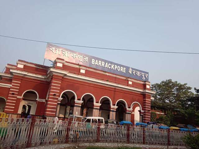   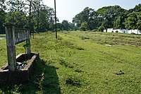 From the top : Barrackpore railway station Mangal Pandey Park Barrackpore Trunk Road Race course Track Ground | |
 Barrackpore Location in West Bengal, India  Barrackpore Barrackpore (India) | |
| Coordinates: 22.76°N 88.37°E | |
| Country | |
| State | |
| District | North 24 Parganas |
| Region | Greater Kolkata |
| Government | |
| • Type | Municipality |
| • Body | Barrackpore Municipality |
| • Chairman | Uttam Das, (AITC)[1] |
| • MP | Arjun Singh, (BJP) |
| • MLA | Shilbhadra Dutta, (AITC) |
| • Police Commissioner | Manoj Kumar Verma, IPS |
| • Deputy Commissioner of Police | Ajay Kumar Thakur, IPS |
| Area | |
| • Total | 10.61 km2 (4.10 sq mi) |
| Elevation | 15 m (49 ft) |
| Population (2011) | |
| • Total | 152,783 |
| • Density | 14,000/km2 (37,000/sq mi) |
| Demonym(s) | Barrakpurians |
| Languages | |
| • Official | Bengali[2][3] |
| • Additional official | English[3] |
| Time zone | UTC+5:30 (IST) |
| PIN | 700120, 700121, 700122, 700123 |
| Telephone code | +91 33 |
| Vehicle registration | WB-23/WB-24 |
| Lok Sabha constituency | Barrackpore |
| Vidhan Sabha constituency | Barrackpore |
| Police Jurisdiction | Barrackpore Police Commisionarate |
| Website | www |
Etymology
The name Barrackpore may have originated from the English word barracks, as it was the site of the first cantonment of the British East India Company. Alternatively, the Ain-i-Akbari suggests that the name comes from "Barbakpur". Manasa Vijay, written by Bipradas Pipilai, refers to Barrackpore as "Chanak".
History
The earliest references to the Barrackpore region are found in the writings of the Greek navigators, geographers, chronicles and historians of the 1st century BC to the 3rd century AD. These authors generally referred to the country of a people variously called the Gangaridae, Gangaridai, Gandaritai etc. By the 15th and 16th centuries, Chanak and the other towns in the region had become populous river towns.[4] The Statistical Account of Bengal by W.W.Hunter mentions the towns and villages of this subdivision on the banks of the Hooghly river as chief trading and marketing centres: "On The Hugli- Calcutta, the chief seat of commerce in India. Baranagar, Dakhineswar, Agarpara, Panihati, Sukchar- Khardah, Barrackpur, Nawabganj, Ichapore, Shyam Nagar, Naihati and Halisahar contain large bazaars for sale of miscellaneous goods."[5]
Under the Mughal Empire, Bengal was divided into Circars, or administrative subunits, each of which was ruled over by a Mahal. The name "Barbuckpur", another name for Barrackpore, is associated with a Mahal in the Ain-e-Akbari. From the 17th century, the area was ruled over by a line of Zamindars based in Nona Chandanpukur, Barrackpore.
The first British barrack or cantonment in India was built in the town in 1772. After the British crown assumed direct control of India, the sprawling Government House and the Government Estate were built in Barrackpore to provide the viceroy with a suburban residence 15 miles (24 km) outside of Calcutta.
Two rebellions against British authority took place in Barrackpore in the 19th century. The first of these was Barrackpore Mutiny of 1824, led by Sepoy Bindee Tiwary.[6] In this rebellion, 47th Bengal Native Infantry refused to board boats to cross the sea for various reasons including social taboo "Kala pani (taboo)" to Burma in the First Anglo-Burmese War. Consequently, British-manned artillery fired upon and "erased" them.[7] In 1857, Barrackpore was the scene of an incident that some credit with starting the Indian rebellion of 1857: an Indian soldier, Mangal Pandey, attacked his British commander, and was subsequently court-martialed. His regiment was disbanded, an action which offended a number of sepoys and is considered to have contributed to the anger that fueled the rebellion. In order to commemorate his sacrifice, a park named 'Sahid Mangal Pandey Udyan' was opened in the serenity of river Hoogly. The Army cantonment of Barrackpore also houses another significant historical landscape called the RCTC area, now populated by the defence quarters.[8]
Geography
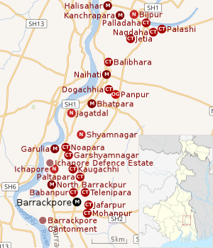 |
| Cities and towns in the northern portion of Barrackpore subdivision in North 24 Parganas district M: municipal city/ town, CT: census town, N: neighbourhood, OG: outgrowth Owing to space constraints in the small map, the actual locations in a larger map may vary slightly |
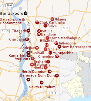 |
| Cities and towns in the southern portion of Barrackpore subdivision in North 24 Parganas district M: municipal city/ town, CT: census town, N: neighbourhood/ administrative location Owing to space constraints in the small map, the actual locations in a larger map may vary slightly |
Background
Historically, the town was a military and administrative center under British rule and was the scene of several acts of rebellion against Britain during the 19th century. The oldest cantonment in India and the Police Training Academy in West Bengal are both located in Barrackpore. Barrackpore is also the seat for the Sub-Divisional Court of North 24 Parganas District.
Location
96% of the population of Barrackpore subdivision (presented in the maps alongside) live in urban areas. In 2011, it had a density of population of 10,967 per km2. The subdivision has 16 municipalities and 24 census towns.[9]
For most of the cities/ towns information regarding density of population is available in the Infobox. Population data is not available for neighbourhoods. It is available for the entire Municipal area and thereafter ward-wise.
All places marked on the map are linked in the full-screen map.
Barrackpore is bounded by North Barrackpur and Jafarpur on the north, Mohanpur, Chak Kanthalia, Ruiya and Patulia on the east, Titagarh on the south, and the Hooghly and Barrackpur Cantonment on the west.[10][11]
Police station
Barrackpore police station under Barrackpore Police Commissionerate has jurisdiction over Barrackpore Municipal area.[12][13]
Post Offices
Barrackpore is the head office of the North Presidency Division of North 24 Parganas district in Calcutta region. It has a delivery post office, with PIN 700120. Other post offices with the same PIN are Monirampur, Nayapally, Orderly Bazar, Vivekananda Math, Barrackpore Bazar, Barrackpore Government Housing and Ghoshpara Road.[14]
Sewli Telenipara has a delivery sub post office, with PIN 700121 in the North Presidency Division of North 24 Parganas district in Calcutta region. Other post offices with the same PIN are Nilganj Bazaar, Beraberia and Suryapur.[15]
Anandapuri has a non-delivery sub post office, with PIN 700122 in the North Presidency Division of North 24 Parganas district in Calcutta region. Other post offices having the same PIN are Nonachandanpukur and Jafarpur.[16]
Barrackpore RS has a non-delivery sub post office, with PIN 700123 in the North Presidency Division of North 24 Parganas district in Calcutta region. Other post offices having the same PIN are Panpara and Talpukur.[17]
Demographics
Population
| Population of Barrackpore | |||
|---|---|---|---|
| Census | Population | %± | |
| 1901 | 19,307 | — | |
| 1911 | 27,605 | 43.0% | |
| 1921 | 22,460 | −18.6% | |
| 1931 | 14,413 | −35.8% | |
| 1941 | 21,773 | 51.1% | |
| 1951 | 42,639 | 95.8% | |
| 1961 | 63,778 | 49.6% | |
| 1971 | 96,889 | 51.9% | |
| 1981 | 115,516 | 19.2% | |
| 1991 | 142,557 | 23.4% | |
| 2001 | 144,391 | 1.3% | |
| 2011 | 152,783 | 5.8% | |
| Sources:[18] | |||
As per the 2011 Census of India, Barrckpore had a total population of 152,783, of which 78,349 (51%) were males and 74,434 (49%) were females. Population below 6 years was 11,786. The total number of literates in Barrackpore was 125,144 (88.76% of the population over 6 years).[19]
As of the 2001 India Census,[20] Barrackpore had a population of 144,331. Men constitute 53% of the population and women 47%. Barrackpore has an average literacy rate of 81%, higher than the national average of 59.5%. 8% of the population is under 6 years of age.
The majority of the population is Bengali and Hindu.
Kolkata Urban Agglomeration
The following Municipalities, Census Towns and other locations in Barrackpore subdivision were part of Kolkata Urban Agglomeration in the 2011 census: Kanchrapara (M), Jetia (CT), Halisahar (M), Balibhara (CT), Naihati (M), Bhatpara (M), Kaugachhi (CT), Garshyamnagar (CT), Garulia (M), Ichhapur Defence Estate (CT), North Barrackpur (M), Barrackpur Cantonment (CB), Barrackpore (M), Jafarpur (CT), Ruiya (CT), Titagarh (M), Khardaha (M), Bandipur (CT), Panihati (M), Muragachha (CT) New Barrackpore (M), Chandpur (CT), Talbandha (CT), Patulia (CT), Kamarhati (M), Baranagar (M), South Dumdum (M), North Dumdum (M), Dum Dum (M), Noapara (CT), Babanpur (CT), Teghari (CT), Nanna (OG), Chakla (OG), Srotribati (OG) and Panpur (OG).[21]
Infrastructure
As per the District Census Handbook 2011, Barrackpore Municipal city covered an area of 10.61 km2. Amongst the civic amenities it had 172.63 km of roads and open drains. Amongst the medical facilities It had 40 medicine shops. Amongst the educational facilities It had 62 primary schools, 12 middle schools, 1 secondary school, 11 senior secondary schools and 3 non-formal education centres. Amongst the social, recreational and cultural facilities it had 1 old age home, 6 auditorium/ community halls, 2 public libraries and 6 reading rooms. Amongst the commodities manufactured were cottage industry and confectionery items. It had 11 bank branches.[22]
Economy
The Army/Airforce cantonment is the biggest landscape of the town of Barrackpore, while agriculture is the main base of the subdivision's economy. Floriculture, pisciculture and horticulture have also flourished in the town. Central Inland Fisheries Research Institute has been established at Barrackpore to promote production of fishes mainly in ponds and rivers. A well-developed irrigation system has been constructed in the subdivision to promote agriculture. Low interest loans have also been used to encourage the expansion of farming and the development of agricultural infrastructure.
The primary industry in Barrackpore is jute processing, centered in a number of jute mills on the side of the river. Rifle Factory Ishapore is one of the most important arms factories of India,Hindustan Aeronautics Limited, one of the premier Aerospace Industry in Asia, one of the Division situated in Barrackpore for Cheetah Chetak Helicopter. . Mulazore Thermal Power Plant at Shyamnagar was one of the oldest power plants in India, but was shut down in 2004. Dry cells produced by Exide, and cables produced by Nicco are other industrial products.
Transport
Road
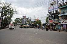
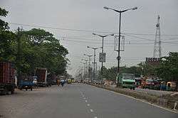
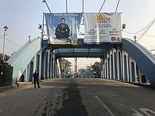
Barrackpore Trunk Road (B.T. Road) (part of both SH 1 and SH 2) connects Barrackpore Chiria More with Kolkata. Ghoshpara Road connects Barrackpore railway station area with Kanchrapara and goes on to link with the adjacent district of Nadia. Surendranath Banerjee Road connects Manirampore with Barrackpore railway station area via Barrackpore Chiria More. Barrackpore-Barasat Road (part of SH 2) starts at Lalkuthi and goes upto Barasat via Nilganj. Many buses ply along these roads. Barrackpore Rail Overbridge was opened in 2013 at Lalkuthi to make transport-communication easier and smoother.[23]
Bus routes
- 78 Esplanade — Barrackpore
- 81 Barasat — Fishery Gate
- 81/1 Barasat — Rajchandrapur
- 85 Kanchrapara — Barrackpore Court
- MM5 Habra — Barrackpore Court
WBTC Routes
CSTC Bus
- S32 Howrah Station — Barrackpore Dhobi Ghat
- S34B Barasat State University — Barrackpore Dhobi Ghat
- S34C Nagerbazar - Barasat State University
- E32 Howrah Station - Nilgunge Depot
- AC20 Santragachi - Barrackpore Dhobi Ghat
CTC Bus
- C28 Howrah Station - Barrackpore Dhobi Ghat
- C29 Barasat - Barrackpore Dhobi Ghat
- C50 Howrah Station - Shyamnagar
- C51 Naihati - Nabanna
- D24 Barrackpore — Jagulia
- D25 Barrackpore - Ranaghat
- D27 Naihati - Jadavpur
- E59 Naihati - Digha
Bus Routes without Numbers
- Barasat - Kamalpur
- Naihati - Egra
- Salap - Barrackpore
- Howrah Station - Barrackpore
SBSTC Routes
- Haldia - Barrackpore
- Naihati - Digha
- Kanchrapara - Digha
- Barrackpore - Durgapur
- Kalyani - Digha
- Barrackpore - Digha
Railways
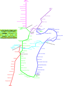
Barrackpore has been serviced by rail since 1862. It takes about 35–40 minutes by suburban train to reach Barrackpore railway station from Sealdah Station. The Sealdah-Ranaghat Line runs through this city and connects to Howrah, Bandel, Burdwan, Kalyani and Ranaghat. It is part of the Kolkata Suburban Railway system. Former Rail Minister Mamata Banerjee announced the extension of Metro Rail project to Barrackpore (Kolkata Metro Line 5) which was later shelved infinitely.
Ferry
There are three Ferry ghats in Barrackpore. Barrackpore Ferry Ghat links to Jugal Adhya Ferry Ghat across the Hooghly River in Serampore. Babaji Ghat at Monirampore links to Chatra Char Poisar Ghat at Serampore and Dui Poisar Ghat links to Sheoraphuli Ghat.[24]
Air
Barrackpore Air Force Station is an Indian Air Force base located at Barrackpore. It is one of the oldest stations in the IAF, operating transport units. One of the Mi-17 squadrons is based here. Netaji Subhash Chandra Bose International Airport in Dum Dum, Kolkata is the nearest airport.
Heritage and culture
Barrackpore was home to a number of significant members of the Indian independence movement, many of whom have memorials in the subdivision. Surendranath Banerjee, who was called the father of Indian Nationalist Movement, lived in Barrackpore. The house of Surendranath at Monirampur of Barrackpore has been converted into the Mahadevananda Mahavidyalaya and Netaji Subhas Open University. Bengali author Bharat Chandra Ray Gunakar, known for writing Annada Mangal in the medieval period, lived at Mulajore. Ramprasad Sen, who authored many religious songs, was born at Halisahar in this subdivision. Bankim Chandra Chattopadhyaya, the author of India's national song "Vande Mataram", was born at Naihati, in Barrackpore subdivision. Shaurya Chakra (posthumous) awardee Captain Sekhar Ghosh was from Barrackpore.
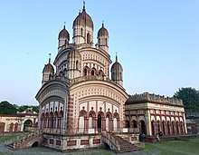
The towns of Panihati and Khardaha are known for having been visited by Chaitanya Mahaprabhu and Nityananda Prabhu some 500 years ago. Annual festivals and melas are held at these places and draw large numbers of devotees. Later visitors included Sri Ram Krishna Paramahansa, Gurudev Rabindranath Tagore, and Mahatma Gandhi. The Gandhi Ghat is located on the east bank of the Hooghly; a Gandhi museum nearby has a rare collection of books and articles used by Gandhi.
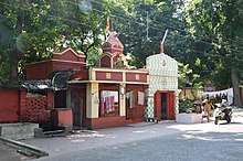
The Sukanta Sadan theatre hall (named after the revolutionary poet Sukanta Bhattacharya) is located in the main town. There are many cinema halls in Barrackpore and its adjacent localities. The Sahid Mangal Pandey Udyan (Nishan Ghat) park facing the Ganges at Barrackpore is a crowdpuller.
Bengali festivals such as Durga Puja, and Kali puja are celebrated every year. There is a month-long fair each December–January (Bengali month of Poush) at the temple of the goddess Kali at Shyamnagar on the bank of the Ganges.
Education
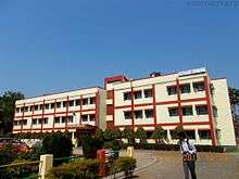
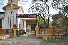
Barrackpore is home to numerous schools, colleges and Madrasahs. Barrakpore can be called the school hub for the surrounding towns having dozens of high-schools in a small area. Barrackpore Government High School, Ramakrishna Vivekananda Mission School, Barrackpore Girls' High School are among the high schools from Barrackpore. Among the colleges located in Barrackpore are Barrackpore Rastraguru Surendranath College and Mahadevananda Mahavidyalaya. The area also has two engineering colleges, St. Mary's Technical Campus Kolkata being affiliated to AICTE, several polytechnic institutes and an international boarding school, Adamas International School.
Barrackpore is the home to many Primary and Play Schools like Swami Vivekananda Centre for Learning Barrackpore (earlier Naba Nalanda School Estd. 1979), kidzee, Path Bhaban, Little laureates as well as secondary schools such as- Assembly of Christ School, St. Augustine's Day School Barrackpore (established in 1985),Modern School (established in 1957),Assembly of Angels Secondary School, Douglas Memorial Higher Secondary School, Army Public School Barrackpore, Kendriya Vidyalaya,Titagarh Krishnanath Municipal High School E. T. C.Barrackpore Government High School is one of the oldest school in West Bengal and the oldest school of Barrackpore. See also – List of West Bengal districts ranked by literacy rate
Healthcare

Medical facilities available in Barrackpore are B.N. Bose Subdivisional Hospital (with 200 beds), Barrackpore Cantonment Hospital (with 48 beds), Barrackpore Police Case Hospital (with 6 beds) and Police Brigade Hospital (with 120 beds).[25] Amongst the private medical facilities are Sarada Seva Sadan, Disha Eye Hospital and Disha Cataract and Refractive Surgi Centre.[26]
See also
- Barrackpore I CD Block
- Barrackpore II CD Block
- Barrackpore, Trinidad and Tobago
- Barrackpore Mutiny of 1824
- Mangal Pandey#Indian Rebellion of 1857
References
- Official District Administration site Archived 15 January 2007 at the Wayback Machine
- "52nd REPORT OF THE COMMISSIONER FOR LINGUISTIC MINORITIES IN INDIA" (PDF). Nclm.nic.in. Ministry of Minority Affairs. p. 85. Archived from the original (PDF) on 25 May 2017. Retrieved 29 August 2019.
- "Fact and Figures". Wb.gov.in. Retrieved 29 August 2019.
- De, Barun. W.B. District Gazetteer, 24 Parganas ed. 1994.
- Hunter W.W. A Statistical Account of Bengal, London, Trübner & Co.1875-1879
- Jaideep Mazumder, The First Martyr, OUTLOOK, 25 August 2008, P.20
- Wolpert, Stanley (2009). A New History of India (8th ed.). New York, NY: Oxford UP. p. 224. ISBN 978-0-19-533756-3.
- http://www.rctconline.com/booktext/book7.html Archived 5 July 2008 at the Wayback Machine
- "District Statistical Handbook". North 24 Parganas 2013, Tables 2.1, 2.2, 2.4b. Department of Statistics and Programme Implementation, Government of West Bengal. Archived from the original on 21 January 2019. Retrieved 2 May 2018.
- "District Census Handbook North Twenty Four Parganas, Census of India 2011, Series 20, Part XII A" (PDF). Map of Barrackpore I CD Block on Page 365. Directorate of Census Operations, West Bengal. Retrieved 27 June 2018.
- "District Census Handbook North Twenty Four Parganas, Census of India 2011, Series 20, Part XII A" (PDF). Map of Barrackpore II CD Block on Page 379. Directorate of Census Operations, West Bengal. Retrieved 27 June 2018.
- "District Statistical Handbook". North 24 Parganas 2013, Table 2.1. Department of Statistics and Programme Implementation, Government of West Bengal. Archived from the original on 21 January 2019. Retrieved 11 June 2018.
- "Barrackpore Police Commissionerate". List of Police Stations with telephone numbers. West Bengal Police. Archived from the original on 12 June 2018. Retrieved 11 June 2018.
- "Barrackpore PIN Code". pincodezip.in. Retrieved 11 July 2018.
- "Sewli Telenipara PIN Code". pincodezip.in. Retrieved 11 July 2018.
- "Anandapuri PIN Code". pincodezip.in. Retrieved 11 July 2018.
- "Barrackpore RS PIN Code". pincodezip.in. Retrieved 11 July 2018.
- "District Census Handbook North Twenty Four Parganas, Census of India 2011, Series 20, Part XII A" (PDF). Section II Town Directory, Pages 781-783 Statement I: Growth History, Pages 799-803. Directorate of Census Operations V, West Bengal. Retrieved 11 June 2018.
- "2011 Census – Primary Census Abstract Data Tables". West Bengal – District-wise. Registrar General and Census Commissioner, India. Retrieved 7 June 2018.
- "Census of India 2001: Data from the 2001 Census, including cities, villages and towns (Provisional)". Census Commission of India. Archived from the original on 16 June 2004. Retrieved 1 November 2008.
- "Provisional Population Totals, Census of India 2011" (PDF). Constituents of Urban Agglomeration Having Population Above 1 Lakh. Census of India 2011. Retrieved 7 June 2018.
- "District Census Handbook North Twenty Four Parganas, Census of India 2011, Series 20, Part XII A" (PDF). Section II Town Directory, Pages 781-783 Statement I: Growth History, Pages 799-803; Statement II: Physical Aspects and Location of Towns, Pages 791-794; Statement III: Civic and other Amenities, Pages 795-796; Statement IV: Medical Facilities 2009, Pages 803-805 Section: Educational, Recreational and Cultural Facilities. Directorate of Census Operations V, West Bengal. Retrieved 31 May 2018.
- "Barrackpore Bridge".
- Google maps
- "Health & Family Welfare Department". Health Statistics. Government of West Bengal. Retrieved 12 July 2018.
- "Hospitals in Kolkata". Credihealth. Retrieved 19 February 2019.
External links
| Wikisource has the text of the 1911 Encyclopædia Britannica article Barrackpur. |
![]()

North 24 Parganas district topics | |||||||||
|---|---|---|---|---|---|---|---|---|---|
| General |
| ||||||||
| Subdivisions | |||||||||
| Municipalities | |||||||||
| Community development blocks |
| ||||||||
| Rivers | |||||||||
| Transport |
| ||||||||
| Railway stations |
| ||||||||
| Institutes of higher learning |
| ||||||||
| Lok Sabha constituencies | |||||||||
| Vidhan Sabha constituencies |
| ||||||||
| Former Vidhan Sabha constituencies | |||||||||
| See also |
| ||||||||
| Kolkata Municipal Corporation |
|
|---|---|
| Kolkata Urban Agglomeration Outside KMC |
|
| |
| Authority control |
|
|---|