Žepče
| Žepče Жепче | |||
|---|---|---|---|
| Town and municipality | |||
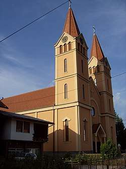 Church of St.Anthony of Padua | |||
| |||
 Žepče Location of Žepče | |||
| Coordinates: 44°26′N 18°02′E / 44.433°N 18.033°E | |||
| Country |
| ||
| Entity | Federation of Bosnia and Herzegovina | ||
| Canton | Zenica-Doboj | ||
| Government | |||
| • Municipality president | Mato Zovko (HDZ BiH) | ||
| Area | |||
| • Total | 282 km2 (109 sq mi) | ||
| Population (2013 census) | |||
| • Total |
31,582 population_footnotes= | ||
| • Density | 112/km2 (290/sq mi) | ||
| Time zone | UTC+1 (CET) | ||
| • Summer (DST) | UTC+2 (CEST) | ||
| Area code(s) | +387 32 | ||
| Website | http://www.opcina-zepce.com | ||


Žepče is a town and municipality located in Zenica-Doboj Canton of the Federation of Bosnia and Herzegovina, an entity of Bosnia and Herzegovina. It is situated in central Bosnia and Herzegovina, between Doboj and Zenica. As of 2013, it has a population of 31,582 inhabitants.
The river Bosna flows through this town. Near by the town and within the town, there are 14 springs of mineral water. Žepče is in the valley and surrounded by mountains.
History
The town was first mentioned in 1458 in a charter issued by the Bosnian king Stjepan Tomašević.
"... Pissanna Žepču va ljetu 1458. oktombrija 14. dan." (Written in Žepče in the year 1458. 14.day of October). Žepče during the Yugoslav Wars suffered greatly,with almost the entire town being destroyed after the war.
Demographics
In 2001 the following Croat villages from the municipalities of Maglaj and Zavidovići merged with the municipality of Žepče to form one entity with Croat majority: Adže, Pire, Ponijevo, Matina, Ljubatovići, Grabovica, Čustovo Brdo, Komšići, Radunice, Globarica, Brankovići, Donji Lug, Gornji Lug, Vrbica, Debelo Brdo, Osova, Vinište and Gornja Lovnica.
Municipality Population 1991
| Ethnic Composition | |||||
| Bosniaks | Serbs | Croats | Yugoslavs | Others | Total |
| 1961 | |||||
| 5,038 36.18% | 2,033 14.60% | 5,978 42.93% | 821 5.90% | 54 0.39% | 13,924 |
| 1971 | |||||
| 7,531 44.54% | 2,028 11.99% | 7,174 42.43% | 56 0.33% | 117 0.71% | 16,906 |
| 1981 | |||||
| 8,769 44.39% | 2,004 10.14% | 7,813 39.55% | 933 4.72% | 235 1.20% | 19,754 |
| 1991 | |||||
| 10,820 47.11% | 2,278 9.92% | 9,100 39.62% | 546 2.38% | 222 0.97% | 22,966 |
| 2011 | |||||
| 11,727 38.80% | 501 1.65% | 17,801 58.90% | 0.00 0.00% | 111 0.36% | 30,219 |
Town population in 1991
| Ethnic composition | |||||||||||
| Year | Bosniaks | % | Serbs | % | Croats | % | Yugoslavs | % | Others | % | Total |
| 1961 | 1,312 | 48.43% | 349 | 12.88% | 461 | 17.02% | 555 | 20.49% | 32 | 1.18% | 2,709 |
| 1971 | 2,242 | 69.87% | 227 | 7.07% | 637 | 19.85% | 33 | 1.03% | 70 | 2.18% | 3,209 |
| 1981 | 2,337 | 54.90% | 252 | 5.92% | 935 | 21.96% | 640 | 15.03% | 235 | 1.20% | 4,257 |
| 1991 | 3,373 | 60.77% | 267 | 4.81% | 1,448 | 26.09% | 373 | 6.72% | 89 | 1.60% | 5,550 |
Sport
The town was home to local football club NK Žepče (dissolved).
Notable people
- Ivica Marić, basketball player
- Abdulvehab Ilhamija, poet and prose writer
- Emir Preldžić, basketball player
- Nedžad Ibrišimović, writer
Gallery
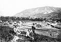 Construction of the railway line (1879)
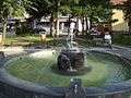 Garden Fountain
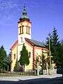 Orthodox Church
- Church of St.Anthony of Padua
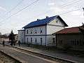 Railway station
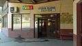 Bus station
.jpg) Bus station (war signs)
Bus station (war signs)
External links
Municipalities of the Zenica-Doboj Canton | ||
|---|---|---|
Coordinates: 44°26′N 18°02′E / 44.433°N 18.033°E
| Wikimedia Commons has media related to Žepče. |