Yèvre-la-Ville
| Yèvre-la-Ville | |
|---|---|
| Commune | |
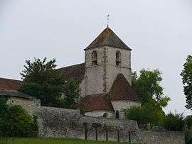 The church in Yèvre-la-Ville | |
 Yèvre-la-Ville Location within Centre-Val de Loire region  Yèvre-la-Ville | |
| Coordinates: 48°08′47″N 2°19′38″E / 48.1464°N 2.3272°ECoordinates: 48°08′47″N 2°19′38″E / 48.1464°N 2.3272°E | |
| Country | France |
| Region | Centre-Val de Loire |
| Department | Loiret |
| Arrondissement | Pithiviers |
| Canton | Malesherbes |
| Intercommunality | Communauté de communes du Pithiverais |
| Government | |
| • Mayor (2014-2020) | Alain Di Stefano |
| Area1 | 26.77 km2 (10.34 sq mi) |
| Population (2014)2 | 714 |
| • Density | 27/km2 (69/sq mi) |
| Time zone | UTC+1 (CET) |
| • Summer (DST) | UTC+2 (CEST) |
| INSEE/Postal code | 45348 /45300 |
| Elevation | 92–127 m (302–417 ft) |
|
1 French Land Register data, which excludes lakes, ponds, glaciers > 1 km2 (0.386 sq mi or 247 acres) and river estuaries. 2 Population without double counting: residents of multiple communes (e.g., students and military personnel) only counted once. | |
Yèvre-la-Ville is a commune in the Loiret department in north-central France.
History
Since 1973, the village of Yèvre-le-Châtel, previously an independent commune, is part of Yèvre-la-Ville. Yèvre-le-Châtel is a member of the Les Plus Beaux Villages de France ("The most beautiful villages of France") association.
See also
| Wikimedia Commons has media related to Yèvre-la-Ville. |
This article is issued from
Wikipedia.
The text is licensed under Creative Commons - Attribution - Sharealike.
Additional terms may apply for the media files.