Courcelles, Loiret
| Courcelles | ||
|---|---|---|
| Commune | ||
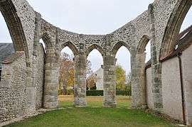 The unfinished choir of the church in Courcelles | ||
| ||
 Courcelles Location within Centre-Val de Loire region  Courcelles | ||
| Coordinates: 48°05′46″N 2°19′08″E / 48.0961°N 2.3189°ECoordinates: 48°05′46″N 2°19′08″E / 48.0961°N 2.3189°E | ||
| Country | France | |
| Region | Centre-Val de Loire | |
| Department | Loiret | |
| Arrondissement | Pithiviers | |
| Canton | Malesherbes | |
| Intercommunality | Communauté de communes du Beaunois | |
| Government | ||
| • Mayor (2008–2014) | Thion Denis | |
| Area1 | 6.3 km2 (2.4 sq mi) | |
| Population (2006)2 | 274 | |
| • Density | 43/km2 (110/sq mi) | |
| Demonym(s) | Courcellois | |
| Time zone | UTC+1 (CET) | |
| • Summer (DST) | UTC+2 (CEST) | |
| INSEE/Postal code | 45110 / | |
| Elevation | 97–118 m (318–387 ft) | |
|
1 French Land Register data, which excludes lakes, ponds, glaciers > 1 km2 (0.386 sq mi or 247 acres) and river estuaries. 2 Population without double counting: residents of multiple communes (e.g., students and military personnel) only counted once. | ||
.svg.png)
Courcelles is a commune in the Loiret department in north-central France.
See also
| Wikimedia Commons has media related to Courcelles (Loiret). |
This article is issued from
Wikipedia.
The text is licensed under Creative Commons - Attribution - Sharealike.
Additional terms may apply for the media files.