Montereau, Loiret
| Montereau | ||
|---|---|---|
| Commune | ||
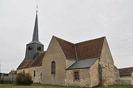 The church in Montereau | ||
| ||
 Montereau Location within Centre-Val de Loire region  Montereau | ||
| Coordinates: 47°51′25″N 2°34′24″E / 47.8569°N 2.5733°ECoordinates: 47°51′25″N 2°34′24″E / 47.8569°N 2.5733°E | ||
| Country | France | |
| Region | Centre-Val de Loire | |
| Department | Loiret | |
| Arrondissement | Montargis | |
| Canton | Lorris | |
| Intercommunality | Communauté de communes du canton de Lorris | |
| Government | ||
| • Mayor (2008–2014) | Jean Debouzy | |
| Area1 | 50.12 km2 (19.35 sq mi) | |
| Population (2006)2 | 601 | |
| • Density | 12/km2 (31/sq mi) | |
| Demonym(s) | Monterelais | |
| Time zone | UTC+1 (CET) | |
| • Summer (DST) | UTC+2 (CEST) | |
| INSEE/Postal code | 45213 /45260 | |
|
1 French Land Register data, which excludes lakes, ponds, glaciers > 1 km2 (0.386 sq mi or 247 acres) and river estuaries. 2 Population without double counting: residents of multiple communes (e.g., students and military personnel) only counted once. | ||

Montereau is a commune in the Loiret department in north-central France.
Geography
The commune is traversed by the Solin River.
See also
| Wikimedia Commons has media related to Montereau. |
This article is issued from
Wikipedia.
The text is licensed under Creative Commons - Attribution - Sharealike.
Additional terms may apply for the media files.