Château-Renard
| Château-Renard | ||
|---|---|---|
| Commune | ||
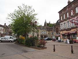 Place de la Republique | ||
| ||
 Château-Renard Location within Centre-Val de Loire region  Château-Renard | ||
| Coordinates: 47°55′53″N 2°55′41″E / 47.9314°N 2.9281°ECoordinates: 47°55′53″N 2°55′41″E / 47.9314°N 2.9281°E | ||
| Country | France | |
| Region | Centre-Val de Loire | |
| Department | Loiret | |
| Arrondissement | Montargis | |
| Canton | Courtenay | |
| Government | ||
| • Mayor (2008–2014) | Marc Benedic | |
| Area1 | 40.34 km2 (15.58 sq mi) | |
| Population (2012)2 | 2,250 | |
| • Density | 56/km2 (140/sq mi) | |
| Demonym(s) | Castel-Renardais | |
| Time zone | UTC+1 (CET) | |
| • Summer (DST) | UTC+2 (CEST) | |
| INSEE/Postal code | 45083 /45220 | |
| Elevation | 104–188 m (341–617 ft) | |
|
1 French Land Register data, which excludes lakes, ponds, glaciers > 1 km2 (0.386 sq mi or 247 acres) and river estuaries. 2 Population without double counting: residents of multiple communes (e.g., students and military personnel) only counted once. | ||

Château-Renard is a commune in the Loiret department in north-central France.
Geography
The commune is traversed by the Ouanne River.
See also
| Wikimedia Commons has media related to Château-Renard. |
This article is issued from
Wikipedia.
The text is licensed under Creative Commons - Attribution - Sharealike.
Additional terms may apply for the media files.