Fleury-les-Aubrais
| Fleury-les-Aubrais | ||
|---|---|---|
| Commune | ||
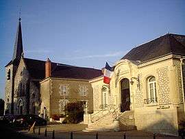 Town hall and church | ||
| ||
 Fleury-les-Aubrais Location within Centre-Val de Loire region  Fleury-les-Aubrais | ||
| Coordinates: 47°57′04″N 1°52′28″E / 47.9512°N 1.8745°ECoordinates: 47°57′04″N 1°52′28″E / 47.9512°N 1.8745°E | ||
| Country | France | |
| Region | Centre-Val de Loire | |
| Department | Loiret | |
| Arrondissement | Orléans | |
| Canton | Fleury-les-Aubrais | |
| Intercommunality | Orléans Métropole | |
| Government | ||
| • Mayor (2001–2008) | Pierre Bauchet | |
| Area1 | 10.12 km2 (3.91 sq mi) | |
| Population (2012)2 | 20,843 | |
| • Density | 2,100/km2 (5,300/sq mi) | |
| Time zone | UTC+1 (CET) | |
| • Summer (DST) | UTC+2 (CEST) | |
| INSEE/Postal code | 45147 /45400 | |
| Elevation |
109–133 m (358–436 ft) (avg. 125 m or 410 ft) | |
|
1 French Land Register data, which excludes lakes, ponds, glaciers > 1 km2 (0.386 sq mi or 247 acres) and river estuaries. 2 Population without double counting: residents of multiple communes (e.g., students and military personnel) only counted once. | ||
.svg.png)
Fleury-les-Aubrais is a commune in the Loiret department in north-central France.
As a part of German-occupied France, its railway station was destroyed in 1944 by the Combined Bomber Offensive.
See also
External links
| Wikimedia Commons has media related to Fleury-les-Aubrais. |
- Official website (in French)
| Authority control |
|---|
This article is issued from
Wikipedia.
The text is licensed under Creative Commons - Attribution - Sharealike.
Additional terms may apply for the media files.