Vitry-aux-Loges
| Vitry-aux-Loges | ||
|---|---|---|
| Commune | ||
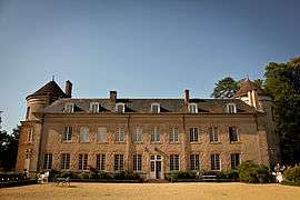 The Château du Plessis-Loiret, in Vitry-aux-Loges | ||
| ||
 Vitry-aux-Loges Location within Centre-Val de Loire region  Vitry-aux-Loges | ||
| Coordinates: 47°58′41″N 2°15′57″E / 47.978°N 2.2659°ECoordinates: 47°58′41″N 2°15′57″E / 47.978°N 2.2659°E | ||
| Country | France | |
| Region | Centre-Val de Loire | |
| Department | Loiret | |
| Arrondissement | Orléans | |
| Canton | Châteauneuf-sur-Loire | |
| Intercommunality | Communauté de communes des Loges | |
| Government | ||
| • Mayor (2008–2014) | Jean-Claude Naizondard | |
| Area1 | 44.06 km2 (17.01 sq mi) | |
| Population (2012)2 | 1,900 | |
| • Density | 43/km2 (110/sq mi) | |
| Demonym(s) | Vitrylogiens | |
| Time zone | UTC+1 (CET) | |
| • Summer (DST) | UTC+2 (CEST) | |
| INSEE/Postal code | 45346 /45530 | |
| Elevation | 107–138 m (351–453 ft) | |
| Website | www.vitry-aux-loges.com | |
|
1 French Land Register data, which excludes lakes, ponds, glaciers > 1 km2 (0.386 sq mi or 247 acres) and river estuaries. 2 Population without double counting: residents of multiple communes (e.g., students and military personnel) only counted once. | ||
.svg.png)
Vitry-aux-Loges is a commune in the Loiret department in north-central France.
See also
| Wikimedia Commons has media related to Vitry-aux-Loges. |
This article is issued from
Wikipedia.
The text is licensed under Creative Commons - Attribution - Sharealike.
Additional terms may apply for the media files.