Walbury Hill
| Walbury Hill | |
|---|---|
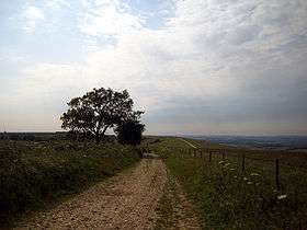 The view from Walbury Hill, looking towards Combe Gibbet | |
| Highest point | |
| Elevation | 297 m (974 ft) |
| Prominence | c. 188 metres (617 ft) |
| Parent peak | Beacon Batch |
| Listing | Marilyn, County Top, Hardy |
| Coordinates | 51°21′08″N 1°27′57″W / 51.35226°N 1.46577°WCoordinates: 51°21′08″N 1°27′57″W / 51.35226°N 1.46577°W |
| Geography | |
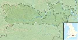 Walbury Hill Walbury Hill in Berkshire | |
| Location | North Wessex Downs AONB, Berkshire, England |
| OS grid | SU373616 |
| Topo map | OS Landranger 174 |
Walbury Hill is a hill in Berkshire, England. At 297 metres (974 ft) above sea level, it is the highest hill in Berkshire and the highest natural point in South East England[1] (West Berkshire being a constituent part of this region), just 3 metres (10 ft) higher than Leith Hill in Surrey. It is in a southwest corner of the county, on a ridge extending into Hampshire and Wiltshire, around 7 kilometres (4.3 mi) southeast of the town of Hungerford.
On the hill's summit is the Iron Age hill fort of Walbury Camp. Combe Gibbet stands on the adjoining Gallows Down.
The true summit is marked by a triangulation pillar approximately 100 metres (330 ft) from the main Test Way. Before the use of satellites was commonplace, Walbury Hill was occasionally used by the BBC as a temporary relay station during the Newbury Races. There is no metalled road across the hill, but the byway is open to all traffic and maintained with a hard gravel surface, because of its previous use by outside broadcast vehicles. The ridged summit is also popular with paragliding enthusiasts.
It is one of three nationally important chalk wild grasslands in the North Wessex Downs, the others being Rushmore and Conholt Downs (SSSI) and part of Hog's Hole (SSSI).[2]
Walbury Hill is the starting point for both the Test Way and the Wayfarers Walk.
There is also a small low-level circular brick building, approximately 6 feet (1.8 metres) high, on the south side of the hill. This appears to be a disused reservoir.
| Wikimedia Commons has media related to Walbury Hill. |
References
- ↑ "Facts about South East England".
- ↑ "LUC Standard Report Template-London" (PDF). Retrieved 2017-02-05.