Eggardon Hill
| Eggardon Hill | |
|---|---|
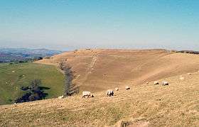 Eggardon Hill from the southeast | |
| Highest point | |
| Elevation | 252 m (827 ft) [1] |
| Prominence | 115 m (377 ft) [1] |
| Listing | Hardy |
| Coordinates | 50°45′00″N 2°39′02″W / 50.75008°N 2.650572°WCoordinates: 50°45′00″N 2°39′02″W / 50.75008°N 2.650572°W |
| Geography | |
| Location | Dorset, England |
| Parent range | Dorset Downs |
| OS grid | SY541947 |
| Topo map | OS Landranger 194 |
Eggardon Hill is located on chalk uplands approximately four miles to the east of Bridport, in the English county of Dorset. It stands 252 metres (827 ft) above sea level,[1] (some sources 254 m[2][3]) and provides panoramic views to the south, north and west. The southern half of the hill is owned and maintained by The National Trust (which permits free public access throughout the year) with the northern part in private ownership.
Eggardon Hill is first documented in the Domesday Book of 1086. From about 300 BC, it was used as a hill fort — an Iron Age defended settlement. It is usually held that such forts were captured and forcibly vacated by the Romans during the Claudian Invasion of 43 AD, although there is only indirect evidence for this; Eggardon Hill itself has never been excavated by archaeologists. The presence of several tumuli (or barrows) on the hill provides another indication of prehistoric use.
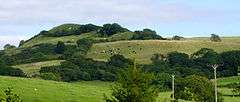
Latterly, notorious smuggler Isaac Gulliver (1745-1822) (who owned Eggardon Hill Farm) is reputed to have planted a stand of pine trees on Eggardon Hill, to provide an aid to navigation for his ships as they approached the Dorset coast. Although the trees were later felled on government orders, the octagonal earthworks used to protect them from the elements is still visible today, and marked on Ordnance Survey maps of the area.
The name Eggardon is derived from an Old English place name, meaning the hill belonging to Eohhere.
References
- 1 2 3 Eggardon Hill at the online Database of British and Irish Hills. Accessed on 22 Mar 2013.
- ↑ Jackson, Mark. "More Relative Hills of Britain" (PDF). Relative Hills of Britain. Archived from the original (PDF) on 12 October 2013. Retrieved 9 September 2011.
- ↑ Summit Listings by Relative Height by Jonathan de Ferranti. Accessed on 25 Mar 2013.
External links
![]()