Nordy Bank
Coordinates: 52°27′30″N 2°37′33″W / 52.4583°N 2.6257°W For the children's novel by Sheena Porter, please see Nordy Bank (novel).
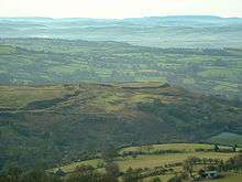
Nordy Bank is an Iron Age hill fort on Brown Clee Hill in the Shropshire Hills AONB in South Shropshire, England.
Location
The nearest village is Clee St. Margaret, overlooking Ludlow, the nearest market town.
Description
The Nordy Bank hill fort is located on a defensible spur of the Clee Hills at 343 metres above sea level overlooking Corve Dale and Wenlock Edge. The defensive ditch earthworks are in good condition although past quarrying has encroached near the site.
The Jack Mytton Way long distance footpath passes adjacent to the site and the Shropshire Way runs 2 km to the northeast.
Nordy Bank is the location setting of Sheena Porter's novel Nordy Bank (1964).
External links
- Nordy Bank on the Megalithic Portal website
- BBC Panoramic of Nordy Bank in summer
- Photos of Nordy Bank and surrounding area on geograph
- Nordy Bank on the Roman-Britain website
| Wikimedia Commons has media related to Nordy Bank. |