Tidbury Ring
 Tidbury Ring | |
 Shown within Hampshire | |
| Location | Hampshire |
|---|---|
| Coordinates | 51°11′01″N 1°20′21″W / 51.1835°N 1.3393°WCoordinates: 51°11′01″N 1°20′21″W / 51.1835°N 1.3393°W |
| History | |
| Periods | Iron Age |
| Site notes | |
| Public access | on private farmland, Tidbury Farm |
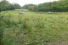
Tidbury Ring is the site of an Iron Age univallate hillfort located in Hampshire. The earthworks have been heavily destroyed by ploughing, but some sections to the south remain in better condition. The entrance lies to the southeast of the fort. The interior is for the most part farmland with the earthworks now covered by small trees and undergrowth[1] Two Roman buildings, possibly a courtyard villa complex were found within the hill-fort. The site is now listed as a scheduled ancient monument no.87[2]
Location
The site is located at grid reference SU463429, to the north of the village of Sutton Scotney, in the county of Hampshire. The A34 dual-carriageway passes immediatrely to the east of the site. The hillfort of Norsebury Ring lies close by to the southeast. The hill has a summit of 114m AOD.
References
- ↑ http://www.themodernantiquarian.com/site/5355/tidbury_ring.html The Modern Antiquarian: Tidbury Ring
- ↑ http://www.hants.gov.uk/hampshiretreasures/vol08/page061.html