Surrey
| Surrey | |||||
|---|---|---|---|---|---|
| County | |||||
| |||||
 Surrey in England | |||||
| Coordinates: 51°15′N 0°25′W / 51.250°N 0.417°WCoordinates: 51°15′N 0°25′W / 51.250°N 0.417°W | |||||
| Sovereign state |
| ||||
| Country |
| ||||
| Region | South East | ||||
| Established | before 1066 | ||||
| Ceremonial county | |||||
| Lord Lieutenant | Michael More-Molyneux | ||||
| High Sheriff | William James Glover [1] (2018-19) | ||||
| Area | 1,663 km2 (642 sq mi) | ||||
| • Ranked | 35th of 48 | ||||
| Population (mid-2017 est.) | 1,185,300 | ||||
| • Ranked | 12th of 48 | ||||
| Density | 712/km2 (1,840/sq mi) | ||||
| Non-metropolitan county | |||||
| County council | Surrey County Council | ||||
| Executive | Conservative | ||||
| Admin HQ | Kingston upon Thames (Extra-territorially) | ||||
| Area | 1,663 km2 (642 sq mi) | ||||
| • Ranked | 25th of 27 | ||||
| Population | 1,185,300 | ||||
| • Ranked | 5th of 27 | ||||
| Density | 712/km2 (1,840/sq mi) | ||||
| ISO 3166-2 | GB-SRY | ||||
| ONS code | 43 | ||||
| GSS code | E10000030 | ||||
| NUTS | UKJ23 | ||||
| Website |
www | ||||
 Districts of Surrey Unitary County council area | |||||
| Districts | |||||
| Members of Parliament | List of MPs | ||||
| Police | Metropolitan Police (Kingston) | ||||
| Time zone | Greenwich Mean Time (UTC) | ||||
| • Summer (DST) | British Summer Time (UTC+1) | ||||
Surrey (/ˈsʌri/ SURR-ee)[2] is a county in South East England, and one of the home counties. It borders Kent to the east, both East & West Sussex to the south, Hampshire to the west, Berkshire to the northwest and Greater London to the northeast.
The county town is popularly considered to be Guildford although Surrey County Council is based in Kingston upon Thames, which since 1965 has been a part of Greater London. With a population of 1.1 million, Surrey is the third-most-populous county in the South East.
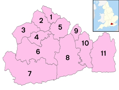
Surrey is divided into eleven districts: Elmbridge, Epsom and Ewell, Guildford, Mole Valley, Reigate and Banstead, Runnymede, Spelthorne, Surrey Heath, Tandridge, Waverley, and Woking. Services such as roads, mineral extraction licensing, education, strategic waste and recycling infrastructure, birth, marriage, and death registration, and social and children's services are administered by Surrey County Council.
The London boroughs of Lambeth, Southwark, Wandsworth, and small parts of Lewisham and Bromley were in Surrey until 1889; as were those of Croydon, Kingston upon Thames, Merton, Sutton and the part of Richmond upon Thames on the right bank of the River Thames until 1965, when they too were absorbed into Greater London, and the county extended north of the Thames by the addition of Spelthorne, as a result of the dissolution of Middlesex. Since the 1965 reform the bordering boroughs of the capital have been those taken from it in 1965 (except for Merton) plus Bromley, Hillingdon and Hounslow.
The form of Surrey which remains since 1965 is a wealthy county due to economic, aesthetic, conservation and logistical factors. It has the highest GDP per capita of any English county, some of the highest property values outside Inner London and also the highest cost of living in the UK outside of the capital.
It has large protected green spaces (such as the North Downs, Greensand Ridge and related Surrey Hills AONB and royal landscapes adjoin it — Windsor Great Park and Bushy Park near to its interior reach of the River Thames). It has four racecourses in horse racing, the most of any Home County and as at 2013 contained 141 golf courses including international competition venue Wentworth. Surrey has proximity to London and to Heathrow and Gatwick airports, along with access to major arterial road routes including the M25, M3 and M23 and frequent rail services into Central London.
Geography

Surrey is divided in two by the chalk ridge of the North Downs, running east-west. The ridge is pierced by the rivers Wey and Mole, tributaries of the Thames, which formed the northern border of the county before modern redrawing of county boundaries, which has left part of its north bank within the county.[3] To the north of the Downs the land is mostly flat, forming part of the basin of the Thames.[3] The geology of this area is dominated by London Clay in the east, Bagshot Sands in the west and alluvial deposits along the rivers. To the south of the Downs in the western part of the county are the sandstone Surrey Hills, while further east is the plain of the Low Weald, rising in the extreme southeast to the edge of the hills of the High Weald.[3] The Downs and the area to the south form part of a concentric pattern of geological deposits which also extends across southern Kent and most of Sussex, predominantly composed of Wealden Clay, Lower Greensand and the chalk of the Downs.[3]
Much of Surrey is in the Metropolitan Green Belt. It contains valued reserves of mature woodland (reflected in the official logo of Surrey County Council, a pair of interlocking oak leaves). Among its many notable beauty spots are Box Hill, Leith Hill, Frensham Ponds, Newlands Corner and Puttenham & Crooksbury Commons.[3]
Surrey is the most wooded county in England, with 22.4% coverage compared to a national average of 11.8%[4] and as such is one of the few counties not to recommend new woodlands in the subordinate planning authorities' plans. Box Hill has the oldest untouched area of natural woodland in the UK, one of the oldest in Europe. Surrey also contains England's principal concentration of lowland heath, on sandy soils in the west of the county.
Agriculture not being intensive, there are many commons and access lands, together with an extensive network of footpaths and bridleways including the North Downs Way, a scenic long-distance path. Accordingly, Surrey provides many rural and semi-rural leisure activities, with a large horse population in modern terms.
The highest elevation in Surrey is Leith Hill near Dorking. It is 294 m (965 ft)[5] above sea level and is the second highest point in southeastern England after Walbury Hill in West Berkshire which is 297 m (974 ft) .
Settlements
Surrey has a population of approximately 1.1 million people.[6] Its largest town is Guildford, with a population of 77,057 (2011 census); Woking is second with 62,796. They are followed by Ewell with 39,994 people and Camberley with 30,155. Towns of between 25,000 and 30,000 inhabitants are Ashford, Epsom, Farnham, Staines and Redhill.[7] Guildford is the historic county town,[8] although the county administration was moved to Newington in 1791 and to Kingston upon Thames in 1893. The county council's headquarters have been outside the county's boundaries since 1 April 1965, when Kingston and other areas were included within Greater London by the London Government Act 1963.[9]
The council abandoned plans in the latter part of the 2000s decade to move its headquarters to Woking.[10] Due to its proximity to London there are many commuter towns and villages in Surrey, the population density is medium to high on residentially developed land and the area is one of the richest parts of the UK. Much of the north of the county is an urban area contiguous to Greater London. In the west, there is a conurbation straddling the Hampshire/Surrey border, including in Surrey Camberley and Farnham.
History
The ancient British and Roman periods
Before Roman times the area today known as Surrey was probably largely occupied by the Atrebates tribe, centred at Calleva Atrebatum (Silchester), in the modern county of Hampshire, but eastern parts of it may have been held by the Cantiaci, based largely in Kent. The Atrebates are known to have controlled the southern bank of the Thames from Roman texts describing the tribal relations between them and the powerful Catuvellauni on the north bank.
In about AD 42 King Cunobelinus (in Welsh legend Cynfelin ap Tegfan) of the Catuvellauni died and war broke out between his sons and King Verica of the Atrebates. The Atrebates were defeated, their capital captured and their lands made subject to Togodumnus, king of the Catuvellauni, ruling from Camulodunum (Colchester). Verica fled to Gaul and appealed for Roman aid. The Atrebates were allied with Rome during the invasion of Britain in AD 43.[11]
During the Roman era, the only important settlement within the historic area of Surrey was the London suburb of Southwark (now part of Greater London), but there were small towns at Staines, Ewell, Dorking, Croydon and Kingston upon Thames.[12] Remains of Roman rural temples have been excavated on Farley Heath and near Wanborough and Titsey, and possible temple sites at Chiddingfold, Betchworth and Godstone.[13] The area was traversed by Stane Street and other Roman roads.[14]
The formation of Surrey
During the 5th and 6th centuries Surrey was conquered and settled by Saxons. The names of possible tribes inhabiting the area have been conjectured on the basis of place names. These include the Godhelmingas (around Godalming) and Woccingas (between Woking and Wokingham in Berkshire). It has also been speculated that the entries for the Nox gaga and Oht gaga peoples in the Tribal Hidage may refer to two groups living in the vicinity of Surrey. Together their lands were assessed at a total of 7,000 hides, equal to the assessment for Sussex or Essex. Surrey may have formed part of a larger Middle Saxon kingdom or confederacy, also including areas north of the Thames. The name Surrey is derived from Sūþrīge (or Suthrige), meaning "southern region", and this may originate in its status as the southern portion of the Middle Saxon territory.[15][16]
If it ever existed, the Middle Saxon kingdom had disappeared by the 7th century, and Surrey became a frontier area disputed between the kingdoms of Kent, Essex, Sussex, Wessex and Mercia, until its permanent absorption by Wessex in 825. Despite this fluctuating situation it retained its identity as an enduring territorial unit. During the 7th century Surrey became Christian and initially formed part of the East Saxon diocese of London, indicating that it was under East Saxon rule at that time, but was later transferred to the West Saxon diocese of Winchester. Its most important religious institution throughout the Anglo-Saxon period and beyond was Chertsey Abbey, founded in 666. At this point Surrey was evidently under Kentish domination, as the abbey was founded under the patronage of King Ecgberht of Kent.[17] However, a few years later at least part of it was subject to Mercia, since in 673-5 further lands were given to Chertsey Abbey by Frithuwald, a local sub-king (subregulus) ruling under the sovereignty of Wulfhere of Mercia.[18] A decade later Surrey passed into the hands of King Caedwalla of Wessex, who also conquered Kent and Sussex, and founded a monastery at Farnham in 686.[19]
The region remained under the control of Caedwalla's successor Ine in the early 8th century.[20] Its political history for most of the 8th century is unclear, although West Saxon control may have broken down around 722, but by 784–5 it had passed into the hands of King Offa of Mercia.[21] Mercian rule continued until 825, when following his victory over the Mercians at the Battle of Ellandun, King Egbert of Wessex seized control of Surrey, along with Sussex, Kent and Essex.[22][23] It was incorporated into Wessex as a shire and continued thereafter under the rule of the West Saxon kings, who eventually became kings of all of England.
Identified sub-kings of Surrey
- Frithuwald (c. 673–675)
- Frithuric? (c. 675 – c. 686)
The West Saxon and English shire
In the 9th century England was afflicted, along with the rest of northwestern Europe, by the attacks of Scandinavian Vikings. Surrey's inland position shielded it from coastal raiding, so that it was not normally troubled except by the largest and most ambitious Scandinavian armies.
In 851 an exceptionally large invasion force of Danes arrived at the mouth of the Thames in a fleet of about 350 ships, which would have carried over 15,000 men. Having sacked Canterbury and London and defeated King Beorhtwulf of Mercia in battle, the Danes crossed the Thames into Surrey, but were slaughtered by a West Saxon army led by King Æthelwulf in the Battle of Aclea, bringing the invasion to an end.[24]
Two years later the men of Surrey marched into Kent to help their Kentish neighbours fight a raiding force at Thanet, but suffered heavy losses including their ealdorman, Huda.[25] In 892 Surrey was the scene of another major battle when a large Danish army, variously reported at 200, 250 and 350 ship-loads, moved west from its encampment in Kent and raided in Hampshire and Berkshire. Withdrawing with their loot, the Danes were intercepted and defeated at Farnham by an army led by Alfred the Great's son Edward, the future King Edward the Elder, and fled across the Thames towards Essex.[26]
Surrey remained safe from attack for over a century thereafter, due to its location and to the growing power of the West Saxon, later English, kingdom. Kingston was the scene for the coronations of Æthelstan in 924 and of Æthelred the Unready in 978, and, according to later tradition, also of other 10th-century Kings of England.[27] The renewed Danish attacks during the disastrous reign of Æthelred led to the devastation of Surrey by the army of Thorkell the Tall, which ravaged all of southeastern England in 1009–11.[28] The climax of this wave of attacks came in 1016, which saw prolonged fighting between the forces of King Edmund Ironside and the Danish king Cnut, including an English victory over the Danes somewhere in northeastern Surrey, but ended with the conquest of England by Cnut.[29]
Cnut's death in 1035 was followed by a period of political uncertainty, as the succession was disputed between his sons. In 1036 Alfred, son of King Æthelred, returned from Normandy, where he had been taken for safety as a child at the time of Cnut's conquest of England. It is uncertain what his intentions were, but after landing with a small retinue in Sussex he was met by Godwin, Earl of Wessex, who escorted him in apparently friendly fashion to Guildford. Having taken lodgings there, Alfred's men were attacked as they slept and killed, mutilated or enslaved by Godwin's followers, while the prince himself was blinded and imprisoned, dying shortly afterwards. This must have contributed to the antipathy between Godwin and Alfred's brother Edward the Confessor, who came to the throne in 1042. This hostility peaked in 1051, when Godwin and his sons were driven into exile; returning the following year, the men of Surrey rose to support them, along with those of Sussex, Kent, Essex and elsewhere, helping them secure their reinstatement and the banishment of the king's Norman entourage. The repercussions of this antagonism helped bring about the Norman Conquest of England in 1066.[30][31]
Domesday Book records that the largest landowners in Surrey at the end of Edward's reign were Chertsey Abbey and Harold Godwinson, Earl of Wessex and later king, followed by the estates of King Edward himself. Apart from the abbey, most of whose lands were within the shire, Surrey was not the principal focus of any major landowner's holdings, a tendency which was to persist in later periods.[n 1] Given the vast and widespread landed interests and the national and international preoccupations of the monarchy and the earldom of Wessex, the Abbot of Chertsey was therefore probably the most important figure in the local elite.
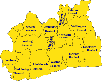
The Anglo-Saxon period saw the emergence of the shire's internal division into 14 hundreds, which continued until Victorian times. These were the hundreds of Blackheath, Brixton, Copthorne, Effingham Half-Hundred, Elmbridge, Farnham, Godalming, Godley, Kingston, Reigate, Tandridge, Wallington, Woking and Wotton.
Identified ealdormen of Surrey
- Wulfheard (c.823)
- Huda (?–853)
- Æðelweard (late 10th century)
- Æðelmær (?–1016)
Later Medieval Surrey
After the Battle of Hastings, the Norman army advanced through Kent into Surrey, where they defeated an English force which attacked them at Southwark and then burned that suburb. Rather than try to attack London across the river, the Normans continued west through Surrey, crossed the Thames at Wallingford in Berkshire and descended on London from the north-west. As was the case across England, the native ruling class of Surrey was virtually eliminated by Norman seizure of land. Only one significant English landowner, the brother of the last English Abbot of Chertsey, remained by the time the Domesday survey was conducted in 1086.[n 2] At that time the largest landholding in Surrey, as in many other parts of the country, was the expanded royal estate, while the next largest holding belonged to Richard fitz Gilbert, founder of the de Clare family.
In 1088, King William II granted William de Warenne the title of Earl of Surrey as a reward for Warenne's loyalty during the rebellion that followed the death of William I. When the male line of the Warennes became extinct in the 14th century, the earldom was inherited by the Fitzalan Earls of Arundel. The Fitzalan line of Earls of Surrey died out in 1415, but after other short-lived revivals in the 15th century the title was conferred in 1483 on the Howard family, who still hold it. However, Surrey was not a major focus of any of these families' interests.
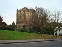
Guildford Castle, one of many fortresses originally established by the Normans to help them subdue the country, was rebuilt in stone and developed as a royal palace in the 12th century.[n 3] Farnham Castle was built during the 12th century as a residence for the Bishop of Winchester, while other stone castles were constructed in the same period at Bletchingley by the de Clares and at Reigate by the Warennes.[32]
During King John's struggle with the barons, Magna Carta was issued in June 1215 at Runnymede near Egham. John's efforts to reverse this concession reignited the war, and in 1216 the barons invited Prince Louis of France to take the throne. Having landed in Kent and been welcomed in London, he advanced across Surrey to attack John, then at Winchester, occupying Reigate and Guildford castles along the way.
Guildford Castle later became one of the favourite residences of King Henry III, who considerably expanded the palace there. During the baronial revolt against Henry, in 1264 the rebel army of Simon de Montfort passed southwards through Surrey on their way to the Battle of Lewes in Sussex. Although the rebels were victorious, soon after the battle royal forces captured and destroyed Bletchingley Castle, whose owner Gilbert de Clare, Earl of Hertford and Gloucester, was de Montfort's most powerful ally.
By the 14th century, castles were of dwindling military importance, but remained a mark of social prestige, leading to the construction of castles at Starborough near Lingfield by Lord Cobham, and at Betchworth by John Fitzalan, whose father had recently inherited the Earldom of Surrey. Though Reigate and Bletchingley remained modest settlements, the role of their castles as local centres for the two leading aristocratic interests in Surrey had enabled them to gain borough status by the early 13th century. As a result, they gained representation in Parliament when it became established towards the end of that century, alongside the more substantial urban settlements of Guildford and Southwark.[33][34] Surrey's third sizeable town, Kingston, despite its size, borough status and historical association with the monarchy, did not gain parliamentary representation until 1832.
Surrey had little political or economic significance in the Middle Ages. Its agricultural wealth was limited by the infertility of most of its soils, and it was not the main power-base of any important aristocratic family, nor the seat of a bishopric.[35] The London suburb of Southwark was a major urban settlement, and the proximity of the capital boosted the wealth and population of the surrounding area, but urban development elsewhere was sapped by the overshadowing predominance of London and by the lack of direct access to the sea. Population pressure in the 12th and 13th centuries initiated the gradual clearing of the Weald, the forest spanning the borders of Surrey, Sussex and Kent, which had hitherto been left undeveloped due to the difficulty of farming on its heavy clay soil.[36]
Surrey's most significant source of prosperity in the later Middle Ages was the production of woollen cloth, which emerged during that period as England's main export industry. The county was an early centre of English textile manufacturing, benefiting from the presence of deposits of fuller's earth, the rare mineral composite important in the process of finishing cloth, around Reigate and Nutfield.[37] The industry in Surrey was focused on Guildford, which gave its name to a variety of cloth, gilforte, which was exported widely across Europe and the Middle East and imitated by manufacturers elsewhere in Europe.[38] However, as the English cloth industry expanded, Surrey was outstripped by other growing regions of production.
Though Surrey was not the scene of serious fighting in the various rebellions and civil wars of the period, armies from Kent heading for London via Southwark passed through what were then the extreme north-eastern fringes of Surrey during the Peasants' Revolt of 1381 and Cade's Rebellion in 1450, and at various stages of the Wars of the Roses in 1460, 1469 and 1471. The upheaval of 1381 also involved widespread local unrest in Surrey, as was the case all across south-eastern England, and some recruits from Surrey joined the Kentish rebel army.
In 1082 a Cluniac abbey was founded at Bermondsey by Alwine, a wealthy English citizen of London. Waverley Abbey near Farnham, founded in 1128, was the first Cistercian monastery in England. Over the next quarter-century monks spread out from here to found new houses, creating a network of twelve monasteries descended from Waverley across southern and central England. The 12th and early 13th centuries also saw the establishment of Augustinian priories at Merton, Newark, Tandridge, Southwark and Reigate. A Dominican friary was established at Guildford by Henry III's widow Eleanor of Provence, in memory of her grandson who had died at Guildford in 1274. In the 15th century a Carthusian priory was founded by King Henry V at Sheen. These would all perish, along with the still important Benedictine abbey of Chertsey, in the 16th-century Dissolution of the Monasteries.
Now fallen into disuse, some English counties had nicknames for those raised there such as a 'tyke' from Yorkshire, or a 'yellowbelly' from Lincolnshire. In the case of Surrey, the term was a 'Surrey capon', from Surrey's role in the later Middle Ages as the county where chickens were fattened up for the London meat markets.
Early Modern Surrey
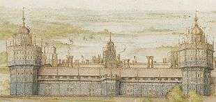
Under the early Tudor kings, magnificent royal palaces were constructed in northeastern Surrey, conveniently close to London. At Richmond an existing royal residence was rebuilt on a grand scale under King Henry VII, who also founded a Franciscan friary nearby in 1499. The still more spectacular palace of Nonsuch was later built for Henry VIII near Ewell.[39] The palace at Guildford Castle had fallen out of use long before, but a royal hunting lodge existed outside the town. All these have since been demolished.
During the Cornish Rebellion of 1497, the rebels heading for London briefly occupied Guildford and fought a skirmish with a government detachment on Guildown outside the town, before marching on to defeat at Blackheath in Kent.[40] The forces of Wyatt's Rebellion in 1554 passed through what was then northeastern Surrey on their way from Kent to London, briefly occupying Southwark and then crossing the Thames at Kingston after failing to storm London Bridge.
Surrey's cloth industry declined in the 16th century and collapsed in the 17th, harmed by falling standards and competition from more effective producers in other parts of England. The iron industry in the Weald, whose rich deposits had been exploited since prehistoric times, expanded and spread from its base in Sussex into Kent and Surrey after 1550.[41] New furnace technology stimulated further growth in the early 17th century, but this hastened the extinction of the business as the mines were worked out.[42] However, this period also saw the emergence of important new industries, centred on the valley of the Tillingbourne, south-east of Guildford, which often adapted watermills originally built for the now moribund cloth industry. The production of brass goods and wire in this area was relatively short-lived, falling victim to competitors in the Midlands in the mid-17th century, but the manufacture of paper and gunpowder proved more enduring. For a time in the mid-17th century the Surrey mills were the main producers of gunpowder in England.[43][44][45] A glass industry also developed in the mid-16th century on the southwestern borders of Surrey, but had collapsed by 1630, as the wood-fired Surrey glassworks were surpassed by emerging coal-fired works elsewhere in England.[46][47] The Wey Navigation, opened in 1653, was one of England's first canal systems.
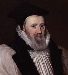
George Abbot, the son of a Guildford clothworker, served as Archbishop of Canterbury in 1611–33. In 1619 he founded Abbot's Hospital, an almshouse in Guildford, which is still operating. He also made unsuccessful efforts to revitalise the local cloth industry. One of his brothers, Robert, became Bishop of Salisbury, while another, Maurice, was a founding shareholder of the East India Company who became the company's Governor and later Lord Mayor of London.
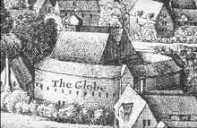
Southwark expanded rapidly in this period, and by 1600, if considered as a separate entity, it was the second-largest urban area in England, behind only London itself. Parts of it were outside the jurisdiction of the government of the City of London, and as a result the area of Bankside became London's principal entertainment district, since the social control exercised there by the local authorities of Surrey was less effective and restrictive than that of the City authorities.[48] Bankside was the scene of the golden age of Elizabethan and Jacobean theatre, with the work of playwrights including William Shakespeare, Christopher Marlowe, Ben Jonson and John Webster performed in its playhouses.[49] The leading actor and impresario Edward Alleyn founded a college in Dulwich with an endowment including an art collection, which was later expanded and opened to the public in 1817, becoming Britain's first public art gallery.
Surrey almost entirely escaped the direct impact of fighting during the main phase of the English Civil War in 1642-6. The local Parliamentarian gentry led by Sir Richard Onslow were able to secure the county without difficulty on the outbreak of war. Farnham Castle was briefly occupied by the advancing Royalists in late 1642, but was easily stormed by the Parliamentarians under Sir William Waller. A new Royalist offensive in late 1643 saw skirmishing around Farnham between Waller's forces and Ralph Hopton's Royalists, but these brief incursions into the western fringes of Surrey marked the limits of Royalist advances on the county. At the end of 1643 Surrey combined with Kent, Sussex and Hampshire to form the South-Eastern Association, a military federation modelled on Parliament's existing Eastern Association.[50]
In the uneasy peace that followed the Royalists' defeat, a political crisis in summer 1647 saw Sir Thomas Fairfax's New Model Army pass through Surrey on their way to occupy London, and subsequent billeting of troops in the county caused considerable discontent.[51] During the brief Second Civil War of 1648, the Earl of Holland entered Surrey in July, hoping to ignite a Royalist revolt. He raised his standard at Kingston and advanced south, but found little support. After confused manoeuvres between Reigate and Dorking as Parliamentary troops closed in, his force of 500 men fled northwards and was overtaken and routed at Kingston.
Surrey had a central role in the history of the radical political movements unleashed by the civil war. In October 1647 the first manifesto of the movement that became known as the Levellers, The Case of the Armie Truly Stated, was drafted at Guildford by the elected representatives of army regiments and civilian radicals from London. This document combined specific grievances with wider demands for constitutional change on the basis of popular sovereignty. It formed the template for the more systematic and radical Agreement of the People, drafted by the same men later that month. It also led to the Putney Debates shortly afterwards, in which its signatories met with Oliver Cromwell and other senior officers in the Surrey village of Putney, where the army had established its headquarters, to argue over the future political constitution of England. In 1649 the Diggers, led by Gerrard Winstanley, established their communal settlement at St. George's Hill near Weybridge to implement egalitarian ideals of common ownership, but were eventually driven out by the local landowners through violence and litigation. A smaller Digger commune was then established near Cobham, but suffered the same fate in 1650.
Modern history
Prior to the Great Reform Act of 1832, Surrey returned fourteen Members of Parliament, two representing the county and two each from the six boroughs of Bletchingley, Gatton, Guildford, Haslemere, Reigate and Southwark. For two centuries before the Reform Act, the dominant political network in Surrey was that of the Onslows of Clandon Park, a gentry family established in the county from the early 17th century, who were raised to the peerage in 1716. Members of the family won at least one of Surrey's two county seats in all but three of the 30 general elections between 1628 and 1768, while they took one or both of the seats for their local borough of Guildford in every election from 1660 to 1830, usually representing the Whig Party after its emergence in the late 1670s. Successive heads of the family held the post of Lord Lieutenant of Surrey continuously from 1716 to 1814.
Until the modern era Surrey, apart from its northeastern corner, was quite sparsely populated in comparison with many parts of southern England, and remained somewhat rustic despite its proximity to the capital. Communications began to improve, and the influence of London to increase, with the development of turnpike roads and a stagecoach system in the 18th century.[52][53] A far more profound transformation followed with the arrival of the railways, beginning in the late 1830s.[54] The availability of rapid transport enabled prosperous London workers to settle all across Surrey and travel daily to work in the capital. This phenomenon of commuting brought explosive growth to Surrey's population and wealth, and tied its economy and society inextricably to London.
There was rapid expansion in existing towns like Guildford, Farnham, and most spectacularly Croydon, while new towns such as Woking and Redhill emerged beside the railway lines.[55][56] The huge numbers of incomers to the county and the transformation of rural, farming communities into a "commuter belt" contributed to a decline in the traditional local culture, including the gradual demise of the distinctive Surrey dialect. This may have survived among the "Surrey Men" into the late 19th Century, but is now extinct.
Meanwhile, London itself spread swiftly across north-eastern Surrey. In 1800 it extended only to Vauxhall; a century later the city's growth had reached as far as Putney and Streatham. This expansion was reflected in the creation of the County of London in 1889, detaching the areas subsumed by the city from Surrey. The expansion of London continued in the 20th century, engulfing Croydon, Kingston and many smaller settlements. This led to a further contraction of Surrey in 1965 with the creation of Greater London, under the London Government Act 1963; however, Staines and Sunbury-on-Thames, previously in Middlesex, were transferred to Surrey, extending the county across the Thames.[57] Surrey's boundaries were altered again in 1974 when Gatwick Airport was transferred to West Sussex.
In 1849 Brookwood Cemetery was established near Woking to serve the population of London, connected to the capital by its own railway service. It soon developed into the largest burial ground in the world. Woking was also the site of Britain's first crematorium, which opened in 1878, and its first mosque, founded in 1889. In 1881 Godalming became the first town in the world with a public electricity supply.
The eastern part of Surrey was transferred from the Diocese of Winchester to that of Rochester in 1877. In 1905 this area was separated to form a new Diocese of Southwark. The rest of the county, together with part of eastern Hampshire, was separated from Winchester in 1927 to become the Diocese of Guildford, whose cathedral was consecrated in 1961.
_(May_2014)_(1).JPG)
During the later 19th century Surrey became important in the development of architecture in Britain and the wider world. Its traditional building forms made a significant contribution to the vernacular revival architecture associated with the Arts and Crafts Movement, and would exert a lasting influence. The prominence of Surrey peaked in the 1890s, when it was the focus for globally important developments in domestic architecture, in particular the early work of Edwin Lutyens, who grew up in the county and was greatly influenced by its traditional styles and materials.[58][59][60]
The late 19th and early 20th centuries saw the demise of Surrey's long-standing industries manufacturing paper and gunpowder. Most of the county's paper mills closed in the years after 1870, and the last survivor shut in 1928. Gunpowder production fell victim to the First World War, which brought about a huge expansion of the British munitions industry, followed by sharp contraction and consolidation when the war ended, leading to the closure of the Surrey powder mills.
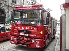
New industrial developments included the establishment of the vehicle manufacturers Dennis Brothers in Guildford in 1895. Beginning as a maker of bicycles and then of cars, the firm soon shifted into the production of commercial and utility vehicles, becoming internationally important as a manufacturer of fire engines and buses. Though much reduced in size and despite multiple changes of ownership, this business continues to operate in Guildford. Kingston and nearby Ham became a centre of aircraft manufacturing, with the establishment in 1912 of the Sopwith Aviation Company and in 1920 of its successor H.G. Hawker Engineering, which later became Hawker Aviation and then Hawker Siddeley.
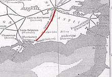
During the Second World War a section of the GHQ Stop Line, a system of pillboxes, gun emplacements, anti-tank obstacles and other fortifications, was constructed along the North Downs. This line, running from Somerset to Yorkshire, was intended as the principal fixed defence of London and the industrial core of England against the threat of invasion. German invasion plans envisaged that the main thrust of their advance inland would cross the North Downs at the gap in the ridge formed by the Wey valley, thus colliding with the defence line around Guildford.
Between the wars Croydon Airport, opened in 1920, served as the main airport for London, but it was superseded after the Second World War by Heathrow, and closed in 1959. Gatwick Airport, where commercial flights began in 1933, expanded greatly in the 1950s and 1960s, but the area occupied by the airport was transferred from Surrey to West Sussex in 1974.
Historic architecture and monuments
Few traces of the ancient British and Roman periods survive in Surrey. There are a number of round barrows and bell barrows in various locations, mostly dating to the Bronze Age. Remains of Iron Age hillforts exist at Holmbury Hill, Hascombe Hill, Anstiebury (near Capel), Dry Hill (near Lingfield), St Ann's Hill (Chertsey) and St George's Hill (Weybridge).[61] Most of these sites were created in the 1st century BC and many were re-occupied during the middle of the 1st century AD.[62] Only fragments of Stane Street and Ermine Street, the Roman roads which crossed the county, remain.
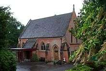
Anglo-Saxon elements survive in a number of Surrey churches, notably at Guildford (St Mary), Godalming (St Peter & St Paul), Stoke D'Abernon, Thursley, Witley, Compton and Albury (in Old Albury).[63]
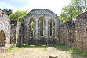
Numerous medieval churches exist in Surrey, but the county's parish churches are typically relatively small and simple, and experienced particularly widespread destruction and remodelling of their form in the course of Victorian restoration. Important medieval[64] church interiors survive at Chaldon, Lingfield, Stoke D'Abernon, Compton and Dunsfold. Large monastic churches fell into ruin after their institutions were dissolved, although fragments of Waverley Abbey and Newark Priory survive. Southwark Priory, no longer in Surrey has survived, though much altered, and is now Southwark Cathedral. Farnham Castle largely retains its medieval structure, while the keep and fragments of the curtain walls and palace buildings survive at Guildford Castle.[65]
Very little non-military secular architecture survives in Surrey from earlier than the 15th century. Wholly or partially surviving houses and barns from that century, with considerable later modifications, include those at Bletchingley, Littleton, East Horsley, Ewhurst, Dockenfield, Lingfield, Limpsfield, Oxted, Crowhurst, Haslemere and Old Surrey Hall.[66]
Major examples of 16th-century architecture include the grand mid-century country houses of Loseley Park and Sutton Place and the old building of the Royal Grammar School, Guildford, founded in 1509.[67] A considerable number of smaller houses and public houses of the 16th century are also still standing. From the 17th century the number of surviving buildings proliferates further. Abbot's Hospital, founded in 1619, is a grand edifice built in the Tudor style, despite its date. More characteristic examples of major 17th-century building include West Horsley Place, Slyfield Manor, and the Guildhall in Guildford.[68]
Literature
Besides its role in Elizabethan and Jacobean theatre, many important writers have lived and worked in Surrey.
- The Owl and the Nightingale, one of the earliest Middle English poems, may have been written by one Nicholas of Guildford, who is mentioned in its text.
- John Donne (1572–1631) lived and worked for a time in Pyrford.
- John Evelyn (1620–1706) was born and spent much of his life in Wotton, and is buried there.
- Daniel Defoe (1659/61-1731) was educated in Dorking.
- William Cobbett (1763–1835) was born and raised in Farnham, later lived in Wyke, where he died, and is buried in Farnham; Surrey features prominently in his Rural Rides.
- Thomas Love Peacock (1785–1866) lived in Lower Halliford, then part of Middlesex, now in Surrey.
- Benjamin Disraeli (1804–81) wrote Coningsby while living in Dorking.
- Alfred Tennyson (1809–92) spent the latter part of his life, and died, in Haslemere.
- Charles Dickens (1812–70) wrote part of The Pickwick Papers in Dorking, and refers to the town in the novel.
- Robert Browning (1812–89) was born in Camberwell, then part of Surrey.
- George Eliot (1819–80) wrote most of Middlemarch while living in Haslemere.
- Matthew Arnold (1822–88) lived in Laleham, then part of Middlesex, now in Surrey.
- George Meredith (1828–1909) lived at Box Hill.
- Lewis Carroll (1832–98) spent much of his time at his sisters' home in Guildford, where he wrote Through the Looking-Glass; he died there and is buried in the town.
- George Bernard Shaw (1856–1950) lived in Woking and later in Hindhead, where he wrote Caesar and Cleopatra.
- Arthur Conan Doyle (1859–1930) lived and wrote many of his books in Hindhead and served as deputy lieutenant of Surrey; the county forms a setting for several of the Sherlock Holmes stories.
- J. M. Barrie (1860–1937) lived in Tilford, and based The Boy Castaways, which later evolved into Peter Pan, in the nearby countryside.
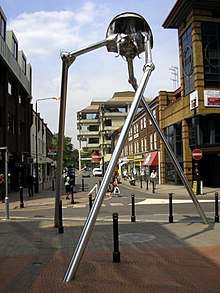
- H. G. Wells (1866–1946) wrote The War of the Worlds while living in Woking; much of northern Surrey is laid waste in the course of the story.
- John Galsworthy (1867–1933) was born in Kingston and the Forsyte Saga is partly set in the area.
- E. M. Forster (1879–1970) lived and wrote in Weybridge and Abinger Hammer.
- P. G. Wodehouse (1881–1975) was born in Guildford and baptised there in St Nicolas' Church.
- Aldous Huxley (1894–1963) was born and raised in Godalming and his ashes are interred at Compton; the end of Brave New World is set in Surrey.
- Rosemary Sutcliff (1920–1992) was born in East Clandon.
- John Osborne (1929–1994) grew up in Stoneleigh.
- Kazuo Ishiguro (born 1954) grew up in Guildford.
Arts and sciences
- William of Ockham (c.1288-c.1348), scholastic philosopher, most famous for "Occam's Razor", came from Ockham.
- Thomas Malthus (1766–1834), pioneer of demography, was born and raised in Westcott, and later lived in Albury.
- Ada Lovelace (1815–52), mathematician, lived at East Horsley.
- Eadweard Muybridge (1830–1904), photographer, was born and raised in Kingston, then part of Surrey.
- Gertrude Jekyll (1843–1932), garden designer, lived for much of her life at Munstead near Godalming, created significant gardens in Surrey and is buried in Busbridge.
- Edwin Lutyens (1869–1944), architect, grew up in Thursley; many of his early works were built in Surrey, including collaborations with Gertrude Jekyll.
- Ralph Vaughan Williams (1872–1958), composer, grew up at Leith Hill and later lived in Dorking.
- Laurence Olivier (1907–89), actor, was born in Dorking.
- Peggy Ashcroft (1907–91), actress, was born and raised in Croydon, then part of Surrey.
- David Lean (1908–91), film director, was born in Croydon.
- Alan Turing (1912–54), mathematician and pioneer of computer science, lived for much of his early life in Guildford.
- Roy Hudd (born 1936), comedian and actor, was born and raised in Croydon.
- Alex Kingston (born 1963), actress, was born and raised in Epsom.
- Tracey Emin (born 1963), artist, was born in Croydon.
Popular music
The "Surrey Delta" produced many of the musicians in 60s British blues movements. The Rolling Stones developed their music at the Crawdaddy Club in Richmond.
- Jimmy Page (born 1944) spent much of his early life in Epsom.
- Jeff Beck (born 1944) was born in Wallington, then part of Surrey.
- Eric Clapton (born 1945) was born and grew up in Ripley.
- Peter Gabriel (born 1950) was born in Chobham and grew up in Surrey. His band Genesis were formed at the Charterhouse School in Godalming.
- The Stranglers were formed in Guildford.
- Paul Weller (born 1958) was born and grew up in Woking, which inspired the song Town Called Malice. The Jam were formed at Sheerwater Secondary School in the town.
- Kirsty MacColl (1959–2000) was born in Croydon, then part of Surrey.
- Norman Cook, aka Fatboy Slim (born 1963) grew up in Reigate.
- Hard-Fi members Richard Archer, Ross Phillips, and Kai Stephens are from Staines-upon-Thames.
- Justin Hawkins, lead singer of rock band The Darkness, was born in Surrey.
- Disclosure members Guy and Howard Lawrence are from Reigate.
Sport
- Cricket makes its first appearance in history in Surrey, in a reference to the game being played at the Royal Grammar School, Guildford in the 16th century (see History of English cricket to 1696). Mitcham Cricket Club, formed in 1685 and the oldest documented club in the game's history, was within Surrey's borders until 1965.[69] The Surrey County Cricket Club has been based at The Oval in Kennington, now part of Greater London, since its foundation in 1845. The club also uses Whitgift School in South Croydon and Woodbridge Road in Guildford for some games. It was one of the original participants in the County Championship and has won the competition 18 times, more than any other county except Yorkshire.
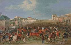
- Epsom Downs Racecourse is the venue for the most prestigious event in British flat horse-racing, the Derby, which has been held there annually since 1780. Surrey is also home to Lingfield, Kempton and Sandown Park Racecourses, presenting an unusually high concentration in one county.[70]
- Brooklands between Woking and Weybridge was the world's first purpose-built motorsport race circuit, opened in 1907 (partly now Mercedes-Benz World). Currently Woking plays host to the headquarters of the McLaren Formula One team, giving Surrey the rarity of having a local F1 team. James Hunt, the 1976 Formula 1 World Driver's Champion was born in Belmont, Sutton, then part of Surrey, in 1947.
- The All England Lawn Tennis Club, venue for the Wimbledon Championships, and the headquarters of the Lawn Tennis Association were within Surrey until 1965.
- Surrey's leading rugby club, Esher, currently compete in the National League 1, the third tier of English rugby.
- Surrey is one of a handful of English counties with no teams in the top 92 football teams, the Football League. Its leading team is Woking, currently playing in the fifth-tier National League.
- Surrey is home to the ice hockey team the Guildford Flames, who compete in the top-tier Elite Ice Hockey League.
- The basketball team Surrey Scorchers, based in Guildford, play in the top tier of British basketball, the British Basketball League.
- The netball team Surrey Storm, based in Guildford play in the Netball Superleague. They are the franchise for the Greater London area and the South East.[71]
- Golf has been played in the county since before 1900 most notably as international venue Wentworth; by 2013 a 142nd co-existing Surrey golf course was in planning consultation; 141 were recorded by The Daily Telegraph newspaper.[72]
- Rowing clubs include Molesey (with an elite development programme hosting several leading British Rowing crews), Walton, (one of the UK's top clubs in the junior category), Weybridge, Weybridge Ladies, Weybridge Mariners, Burway, Staines and Guildford whose top female quad boat won Henley Women's in 2012.
- Volleyball teams include BA, Friends Provident and Guildford International Volleyball Club (whose elite men's team has won the 1st of the 4 National Divisions), while twelve clubs in Surrey and three in south-west Greater London compete in the Surrey Volleyball League.
Surrey football clubs
The county has numerous football teams. In the Combined Counties League can be found the likes of Ash United, Badshot Lea, Banstead Athletic, Camberley Town, Chessington & Hook United, Cobham, Dorking Wanderers, Epsom & Ewell, Epsom Athletic, Farleigh Rovers, Farnham Town, Frimley Green, Horley Town, Knaphill, Mole Valley SCR, Molesey, Sheerwater, Spelthorne Sports and Westfield; Ashford Town, Chertsey Town, Godalming Town and Guildford City play higher in the Southern League; equally Leatherhead, Merstham, Redhill, South Park, Staines Town, Walton Casuals and Walton and Hersham are in the Isthmian; Woking are currently the highest ranked Surrey based club, playing in the National League.
Chelsea F.C. practice at the Cobham Training Centre located in the village of Stoke d'Abernon near the village of Cobham, Surrey. The training ground was built in 2004 and officially opened in 2007.
Local government
History
| Surrey | |
|---|---|
| Population | |
| • 1891 | 452,218[73] |
| • 1971 | 1,002,832[74] |
| History | |
| • Created | c.825 |
| • Abolished | N/A |
| • Succeeded by | N/A |
| Status | Administrative county |
| • HQ |
Newington 1889–1893 Kingston upon Thames from 1893 |
 | |
The Local Government Act 1888 reorganised county-level local government throughout England and Wales. Accordingly, the administrative county of Surrey was formed in 1889 when the Provisional Surrey County Council first met, consisting of 19 aldermen and 57 councillors. The county council assumed the administrative responsibilities previously exercised by the county's justices in quarter sessions. The county had revised boundaries, with the north east of the historic county bordering the City of London becoming part of a new County of London. These areas now form the London Boroughs of Lambeth, Southwark and Wandsworth, and the Penge area of the London Borough of Bromley. At the same time, the borough of Croydon became a county borough, outside the jurisdiction of the county council.
For purposes other than local government the administrative county of Surrey and county borough of Croydon continued to form a "county of Surrey" to which a Lord Lieutenant and Custos Rotulorum (chief magistrate) and a High Sheriff were appointed.
Surrey had been administered from Newington since the 1790s, and the county council was initially based in the sessions house there. As Newington was included in the County of London, it lay outside the area administered by the council, and a site for a new county hall within the administrative county was sought. By 1890 six towns were being considered: Epsom, Guildford, Kingston, Redhill, Surbiton and Wimbledon.[75] In 1891 it was decided to build the new County Hall at Kingston, and the building opened in 1893,[76] but this site was also overtaken by the growing London conurbation, and by the 1930s most of the north of the county had been built over, becoming outer suburbs of London, although continuing to form part of Surrey administratively.
In 1960 the report of the Herbert Commission recommended that much of north Surrey (including Kingston and Croydon) be included in a new "Greater London". These recommendations were enacted in highly modified form in 1965 by the London Government Act 1963. The areas that now form the London Boroughs of Croydon, Kingston, Merton, and Sutton and that part of Richmond south of the River Thames, were transferred from Surrey to Greater London. At the same time part of the county of Middlesex, which had been abolished by the legislation, was added to Surrey. This area now forms the borough of Spelthorne.
Further local government reform under the Local Government Act 1972 took place in 1974. The 1972 Act abolished administrative counties and introduced non-metropolitan counties in their place. The boundaries of the non-metropolitan county of Surrey were similar to those of the administrative county with the exception of Gatwick Airport and some surrounding land which was transferred to West Sussex. It was originally proposed that the parishes of Horley and Charlwood would become part of West Sussex; however this met fierce local opposition and it was reversed by the Charlwood and Horley Act 1974.
Today
After the elections of May 2017 the County Councillors' party affiliations are as follows:[77]
| Party Affiliation | Number | |
|---|---|---|
| Conservative | 61 | |
| Liberal Democrats | 9 | |
| Residents Association | 9 | |
| Labour | 1 | |
| Green | 1 | |
As of 3 May 2012, the Conservative local councillors control of 10 out of 11 councils in Surrey, with Epsom and Ewell in Residents Association control. The Conservatives hold all 11 Parliamentary constituencies within the county borders.[78][79]
Economy
Surrey has the highest GDP per capita in the UK and the highest cost of living in the UK outside of the capital. The county is said to have the highest proportion of millionaires in the UK. The average wage in Surrey is bolstered by the high proportion of residents who work in financial services.
Surrey has more organisation and company headquarters than any other county in the UK. Electronics manufacturers Whirlpool, Canon, Toshiba, Samsung and Philips are housed here, as are distributors Future Electronics, Kia Motors and Toyota UK, the medico-pharma companies Pfizer and Sanofi-Aventis and oil giant Esso. Some of the largest fast-moving consumer goods multinationals in the world have their UK and/or European headquarters here, including Unilever, Procter & Gamble, Superdrug, Nestlé, SC Johnson, Kimberly-Clark and Colgate-Palmolive. NGOs including WWF UK & Compassion in World Farming are also based here. Government Quangos such as SEEDA, SEERA and GOSE are headquartered in Guildford.
Transport
Road
Three major motorways pass through the county. These are:
- M25 (London Orbital) runs through the county, including a long cutting into the Reigate Hill-Walton Down scarp of the North Downs and has 8 junctions in the county.
It connects among others to the M1, M11, M20, M26, M4 and M40. The motorway runs close to Heathrow Airport and the motorway network can be used to access Gatwick, Stansted and Luton Airports and the Channel Tunnel motor vehicle service. - M3 crosses the north-west of the county. It connects London to Southampton and the South West of England (excluding Gloucestershire, Bath and Wiltshire connected by the M4) having in Surrey the Sunbury-on-Thames, M25 interchange and Lightwater/Bagshot junctions.
- M23 (north-south) in effect connects Croydon to Brighton as the dualled A23 trunk road to the north and beyond Crawley. It has junction to a spur to Gatwick Airport on the Surrey/Sussex border. It has a Surrey junction, the M25 Merstham interchange, close to the Reigate M25 junction.
Other major roads include:
- The A3 trunk road from Portsmouth to London. The road now bypasses and historically assisted in the growth of Haslemere, Godalming, Guildford, Esher and Kingston upon Thames. The Hindhead Tunnel bypasses a former bottleneck at Hindhead and the Devil's Punchbowl.
- The A24 from London to Littlehampton and Worthing. In Surrey, it passes through or around Ewell, Epsom, Ashtead, Leatherhead and Dorking. It passes Box Hill, near Dorking. Unlike the A3, which is almost completely dual carriageway, the A24 is, apart from a central Surrey stretch, single carriageway; it bypasses Leatherhead, Dorking and Horsham.
- The A31 trunk road west from Guildford to Bere Regis via Farnham and is connected to the M3 near Winchester and via the A331 near Aldershot. It is dual carriageway along the Hog's Back from the A3 to Farnham. It is one of the ancient routes from London to Winchester, see Pilgrims' Way.
- The short A331 connects the A31 to the M3. It runs along the Surrey – Hampshire border, bypassing Aldershot, Frimley and Farnborough.
Rail
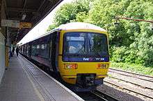
Much of Surrey lies within the London commuter belt with regular services into Central London. South Western Railway is the sole train operator in Elmbridge, Runnymede, Spelthorne, Surrey Heath, Woking and Waverley, and the main train operator in the Borough of Guildford, running regular services into London Waterloo and regional services towards the south coast and South west. Southern is the main train operator in Mole Valley, Epsom and Ewell and Reigate and Banstead and the sole train operator in Tandridge, providing services into London Bridge and London Victoria.
There are a number of national rail routes: in anti-clockwise order, the Waterloo to Reading Line, South Western Main Line, Portsmouth Direct Line, Sutton and Mole Valley Lines (from Horsham, West Sussex itself on the Arun Valley Line from Littlehampton) and the Brighton Main Line.
The Waterloo to Reading Line from Reading, selected stations of Bracknell, Ascot, Sunningdale, and into Surrey and calls at unskipped stops of Virginia Water, Egham, Staines and several other stations in Greater London before terminating at Waterloo. The South Western Main Line runs from Weymouth, Southampton, the significant technology towns of Basingstoke and Farnborough, then normally calls at Woking, up to six other Surrey stops including Walton-on-Thames, and then for fast services Clapham Junction and Waterloo only. The Portsmouth Direct Line is significant in linking Haslemere, Godalming and Guildford to the South Western Main Line at Woking. The Sutton and Mole Valley Lines link Dorking, Leatherhead, Ashtead, Epsom and then towards Waterloo via Ewell West or via Ewell East to London Victoria and also have spurs to the SWML northbound and New Guildford Line southbound. The Brighton Main Line calls at mostly unskipped stops Horley and Redhill before reaching either London Bridge or London Victoria. Reigate is the only town terminus one stop off this main line network, with its station west of Redhill station one stop further from London and is on the east-west North Downs Line.
Consequently, the towns Staines, Woking, Guildford, Walton-on-Thames, Epsom/Ewell and Reigate/Redhill, statistically the largest examples,[80] are established rapid-transit commuter towns for Central London. The above routes have had a stimulative effect. The relative development of Surrey at the time of the Beeching cuts led to today's retention of numerous other commuter routes except the Cranleigh Line, all with direct services to London, including:
- Chertsey Line linking the first two of the above national routes via Chertsey and Addlestone
- New Guildford Line via Claygate and Effingham Junction from Surbiton
- Hampton Court Branch Line to Hampton Court via Thamres Ditton from Surbiton
- Shepperton Branch Line via Sunbury
- Ascot to Guildford Line from Guildford via Wanborough, Ash, into Hampshire to Aldershot, back to Surrey Frimley, Camberley and Bagshot before crossing into Berkshire to Ascot
- Alton Line that calls at the far southwest Surrey outcrop in Farnham into Hampshire with a change to steam at Alton for Alresford via the seasonal and off-peak hours heritage Watercress Line. This line used to run to Winchester.
- Epsom Downs Branch from Sutton and then Belmont in Greater London to Banstead and Epsom Downs only.
- Tattenham Corner Branch Line from Purley, London via Chipstead, Kingswood and Tadworth
- Oxted Line via East Croydon that calls at Oxted and Hurst Green and into East Grinstead with a change for the Bluebell Railway for services to Sheffield Park, or to Uckfield, which was truncated under the Beeching Axe, having previously run to Lewes.
- Redhill to Tonbridge Line via Godstone and Tonbridge connections to Ashford International.
The only diesel route is the east-west route in Surrey, the North Downs Line, which runs from Reading in Berkshire via Farnborough North, Guildford, Dorking Deepdene, Reigate, Redhill and into West Sussex to Gatwick Airport.
Trains to London Waterloo are run by South Western Railway, trains to London Victoria and London Bridge are operated by Southern, and services on the North Downs Line are operated by Great Western Railway. Southeastern previously ran the Redhill to Tonbridge.
Major stations in the county include Guildford (8.0 million passengers),[81] Woking (7.4 million passengers),[81] Epsom (3.6 million passengers),[81] Redhill (3.6 million passengers)[81] and Staines (2.9 million passengers).[81]
Long-distance national services
- From Guildford a daily service with CrossCountry runs to Newcastle via Reading.
- From Gatwick Airport, in addition to the Gatwick Express, the north-south Thameslink route connects 50 stations: London Bridge, London Blackfriars, Farringdon, London St Pancras, Kentish Town, St Albans, Luton Airport Parkway, Luton and Bedford; the Thameslink Programme is under way to extend the line by 2018 to Peterborough, Cambridge and east to Ashford.
Air
Both Heathrow (in the London Borough of Hillingdon) and Gatwick (in Crawley Borough, West Sussex) have a perimeter road in Surrey. A National Express coach from Woking to Heathrow Airport and early-until-late buses to nearby Surrey towns operate.
Fairoaks Airport on the edge of Chobham and Ottershaw is 2.3 miles (3.7 km) from Woking town centre and operates as a private airfield with two training schools and is home to other aviation businesses.
Redhill Aerodrome is also in Surrey.
Education
The UK has a comprehensive, state-funded education system, accordingly Surrey has 37 state secondary schools, 17 Academies, 7 sixth form colleges and 55 state primaries. The county has 41 independent schools, including Charterhouse (one of the nine independent schools mentioned in the Public Schools Act 1868) and the Royal Grammar School, Guildford. More than half the state secondary schools in Surrey have sixth forms. Brooklands (twinned with a site in Ashford, Surrey), Reigate, Esher, Egham, Woking and Waverley host sixth-form equivalent colleges each with technical specialisations and standard sixth-form study courses. Brooklands College offers aerospace and automotive design, engineering and allied study courses reflecting the aviation and motor industry leading UK research and maintenance hubs nearby.
Higher education
- The University of Surrey is based in Guildford and the University for the Creative Arts (UCA) has campuses in Farnham and Epsom
- Royal Holloway, University of London is based in Egham
- The University of Law has a campus in Guildford
Emergency services
Surrey is served by these emergency services.
- Surrey Police, with 12 police stations in Surrey.
- South East Coast Ambulance Service as of 1 July 2006. Previously Surrey Ambulance Service covered Surrey; on 1 July 2006, it merged with Sussex Ambulance Service and Kent Ambulance Service to form the South East Coast Ambulance Service. Surrey has 21 ambulance stations.
- Surrey Fire & Rescue Service, with 24 fire stations in Surrey.
- SURSAR, Surrey Search & Rescue, based in Woking Police Station.
Places of interest
Significant landscapes in Surrey include Box Hill just north of Dorking; the Devil's Punch Bowl at Hindhead and Frensham Common. Leith Hill southwest of Dorking in the Greensand Ridge is the second highest point in southeast England. Witley Common and Thursley Common are expansive areas of ancient heathland south of Godalming run by the National Trust and Ministry of Defence. The Surrey Hills are an area of outstanding natural beauty (AONB).
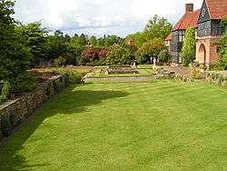
More manicured landscapes can be seen at Claremont Landscape Garden, south of Esher (dating from 1715). There is also Winkworth Arboretum southeast of Godalming and Windlesham Arboretum near Lightwater created in the 20th century. Wisley is home to the Royal Horticultural Society gardens. Kew, historically part of Surrey but now in Greater London, features the Royal Botanic Gardens, Kew, as well as The National Archives for England & Wales.
There are 80 Surrey Wildlife Trust reserves with at least one in all 11 non-metropolitan districts.[82]
Surrey's important country houses include the Tudor mansion of Loseley Park, built in the 1560s and Clandon House, an 18th-century Palladian mansion in West Clandon to the east of Guildford. Nearby Hatchlands Park in East Clandon, was built in 1758 with Robert Adam interiors and a collection of keyboard instruments. Polesden Lacey south of Great Bookham is a regency villa with extensive grounds. On a smaller scale, Oakhurst Cottage in Hambledon near Godalming is a restored 16th-century worker's home.
A canal system, the Wey and Godalming Navigations is linked to the Wey and Arun Canal with future full reopening expected after 2015. Dapdune Wharf in Guildford commemorates the work of the canal system and is home to a restored Wey barge, the Reliance. Furthermore, on the River Tillingbourne, Shalford Mill is an 18th-century water-mill.
Runnymede at Egham is the site of the sealing of the Magna Carta in 1215.
Guildford Cathedral is a 20th century cathedral built from bricks made from the clay of the hill on which it stands.
Brooklands Museum recognises the motoring past of Surrey. The county is also home to the theme parks Thorpe Park and flanks to three sides the farmland and woodland surrounding Chessington World of Adventures in Greater London.
In popular culture
Much of H. G. Wells' 1898 novel The War of the Worlds is set in Surrey with many specific towns and villages identified. The Martians first land on Horsell Common on the north side of Woking, outside the Bleak House pub, now called Sands. The narrator flees in the direction of London, first passing Byfleet and then Weybridge before travelling east along the north bank of the Thames. Jane Austen's novel Emma is set in Surrey and the famous picnic where Emma embarrasses Miss Bates takes place on Box Hill.
The character Ford Prefect from The Hitchhiker's Guide to the Galaxy claimed to be from Guildford in Surrey, but in actuality he was from a small planet somewhere in the vicinity of Betelgeuse. Thomas Paine Kydd, the hero of the Kydd series of naval adventure novels written by Julian Stockwin, starts off as a young wig-maker from Guildford who is pressed into service and thus begins a life at sea. Atonement is set in Surrey.
The late Poet Laureate Sir John Betjeman mentions Camberley in his poem "A Subaltern's Lovesong", while Carshalton forms the literary backdrop to many of the poems by James Farrar. In J.K. Rowling's Harry Potter series, the home of Harry's pernicious relatives, the Dursleys, is set in the fictional town of Little Whinging, Surrey. They lived at Number Four Privet Drive, Little Whinging, Surrey.
The county has also been used as a film location. Part of the movie The Holiday was filmed in Godalming and Shere: Kate Winslet's character Iris lived in a cottage in Shere and Cameron Diaz's character Amanda switched houses with her as part of a home exchange. The final scene of Bridget Jones: The Edge of Reason uses the village church, also in Shere, as does the movie The Wedding Date. In the 1976 film The Omen, the scenes at the cathedral were filmed at Guildford Cathedral.[83]
The film I Want Candy follows two hopeful lads from Leatherhead trying to break into the movies, and was partly filmed in Brooklands College (Weybridge campus). Surrey woodland represented Germany in the opening scene of Gladiator, starring Russell Crowe; it was filmed at the Bourne Woods near Farnham in Surrey.
Scenes for the 2009 BBC production of Emma by Jane Austen, starring Romola Garai and Michael Gambon, were filmed at St Mary the Virgin Church, Send near Guildford and at Loseley House.
See also
- List of Lord Lieutenants of Surrey
- List of High Sheriffs of Surrey
- Custos Rotulorum of Surrey—Keepers of the Rolls
- Surrey (UK Parliament constituency)—Historical list of MPs for Surrey constituency
- Surrey (carriage)
- Healthcare in Surrey
- Surrey Police and Crime Commissioner
Notes
- ↑ Domesday Book valued the Surrey estates of Chertsey Abbey in 1066 at £189 a year, the abbey's only other holdings being £11 worth in Berkshire. Harold's lands in Surrey were valued at £175 a year, while another £15 worth were still entered under the name of his late father Earl Godwin. The revenues of King Edward's Surrey estates totalled £117, Queen Edith's £76, the Archbishopric of Canterbury's £66 and the Bishopric of Winchester's £55, all fractions of vast national holdings. The earl with jurisdiction over Surrey, Harold's brother Leofwine, held only £17 there, from a national total of £290, whose greatest concentrations were in Kent and Sussex, while his mother, Godwin's widow Gytha, held £16 from a total of £590, chiefly clustered in Devon, Wiltshire and Sussex. The other great landowners with Surrey estates were the thegns Ætsere, Ægelnoð and Osward. Ætsere held £61 in Surrey, from a total of £271 including £163 in Sussex, Ægelnoð held £40, from a total of £260 including £71 in Kent, £58 in Sussex and £50 in Oxfordshire, and Osward held £26, from a total of £109 including £65 in Kent, where he was also sheriff. Donald Henson, The English Elite in 1066: Gone but not forgotten (Hockwold-cum-Wilton 2001), pp. 20-23, 26-27, 32-34, 39, 49-50, 64-65, 70, 73, 85, 179-181.
- ↑ This was Oswald, whose brother Wulfwold, Abbot of Chertsey and Bath, died in 1084. Oswald was one of the small number of English landowners who managed to increase their holdings in the wake of the conquest: his estates, centred on Effingham, were valued at £18 a year in 1066, but the acquisition of additional manors raised this to £35 by 1086. His descendants, the de La Leigh family, relinquished the majority of their Surrey lands in the 12th century, but remained landowners in the county until the early 14th century. One of them, William de La Leigh, served as Sheriff of Surrey in 1267.
- ↑ Besides the castles built or rebuilt in stone, remains of Norman castles of earth and timber have been identified at Abinger, Cranleigh, Thunderfield and Walton-on-the-Hill. Brandon and Short, The South East from AD 1000, pp. 46-47.
References
- ↑ "No. 62229". The London Gazette. 15 March 2018. pp. 4814–4814.
- ↑ "surrey | Definition of surrey in English by Oxford Dictionaries". Oxford University Press. Retrieved 7 October 2017.
- 1 2 3 4 5 Natural England - Geodiversity Archived October 2, 2013, at the Wayback Machine.
- ↑ "Surrey's woodlands". Surrey County Council. Archived from the original on 30 September 2007. Retrieved 16 October 2007.
- ↑ Ordnance Survey Landranger Map 187, Dorking & Reigate
- ↑ "2008 mid-year estimates of population". Surrey City Council. Archived from the original on 4 April 2010. Retrieved 15 January 2009.
- ↑ "2001 Census: Town/villages in Surrey with population more than 1000" (PDF). Surrey County Council. Archived from the original (PDF) on 25 October 2007. Retrieved 16 October 2007.
- ↑ "Medieval Guildford—"Henry III confirmed Guildford's status as the county town of Surrey in 1257"". Guildford Borough Council. Archived from the original on 1 November 2013. Retrieved 30 October 2013.
- ↑ "Relationships / unit history of Surrey". Vision of Britain. Archived from the original on 14 October 2007. Retrieved 16 October 2007.
- ↑ Surrey County Council press release 17 January 2006
- ↑ Bird, Roman Surrey, pp. 21-24, 30-31.
- ↑ Bird, Roman Surrey, pp. 49-72.
- ↑ Bird, Roman Surrey, pp. 151-168.
- ↑ Bird, Roman Surrey, pp. 37-48.
- ↑ John Cannon, ed. (2009). "Surrey". A Dictionary of British History (Revised ed.). Oxford University Press. p. 618.
- ↑ Drewett, Rudling and Gardiner, The South East to AD 1000, p. 275.
- ↑ Kirby, The Earliest English Kings, pp. 36, 83.
- ↑ Kirby, The Earliest English Kings, pp. 96–97.
- ↑ Kirby, The Earliest English Kings, pp. 102–103.
- ↑ Kirby, The Earliest English Kings, p. 105.
- ↑ Kirby, The Earliest English Kings, pp. 111–112, 139.
- ↑ Kirby, The Earliest English Kings, pp. 152, 155–156.
- ↑ Anglo-Saxon Chronicles, pp. 60–61
- ↑ Anglo-Saxon Chronicles, pp. 64–65.
- ↑ Anglo-Saxon Chronicles, pp. 64–67.
- ↑ Anglo-Saxon Chronicles, pp. 84–85.
- ↑ Anglo-Saxon Chronicles, pp. 105 (and n. 10), 122–123.
- ↑ Anglo-Saxon Chronicles, pp. 139–141.
- ↑ Anglo-Saxon Chronicles, pp. 150–151.
- ↑ Vladimir Moss. "Martyr-Prince Alfred Of England". Archived from the original on 25 February 2007. Retrieved 16 October 2007.
- ↑ Anglo-Saxon Chronicles, pp. 158–160.
- ↑ Brandon and Short, The South East from AD 1000, p. 48.
- ↑ "Bletchingley 1386–1421". History of Parliament Trust. Retrieved 15 April 2017.
- ↑ "Reigate 1386–1421". History of Parliament Trust. Retrieved 15 April 2017.
- ↑ Brandon and Short, The South East from AD 1000, pp. 8-10, 62-64, 127-131.
- ↑ Brandon, A History of Surrey, pp. 15-18, 37-42.
- ↑ "Reigate 1386–1421". History of Parliament Trust. Retrieved 15 April 2017.
- ↑ "Guildford 1386–1421". History of Parliament Trust. Retrieved 15 April 2017.
- ↑ Brandon and Short, The South East from AD 1000, pp. 197-198.
- ↑ "The Day the Cornish Invaded Guildford". The Surrey Advertiser. 2 June 1989. Archived from the original on 21 June 2007. Retrieved 16 October 2007.
- ↑ Brandon and Short, The South East from AD 1000, pp. 186-190.
- ↑ Brandon, A History of Surrey, pp. 55-57.
- ↑ Glenys and Alan Crocker, Damnable Inventions: Chilworth Gunpowder and the Paper Mills of the Tillingbourne (Guildford: Surrey Industrial History Group 2000), pp. 5-40.
- ↑ Brandon, A History of Surrey, pp. 51-55, 60-61.
- ↑ Brandon and Short, The South East from AD 1000, p. 189.
- ↑ Brandon, A History of Surrey, pp. 57-58.
- ↑ Brandon and Short, The South East from AD 1000, pp. 185-186, 190.
- ↑ Brandon and Short, The South East from AD 1000, pp. 153-154
- ↑ Brandon, History of Surrey, p. 76.
- ↑ Brandon and Short, The South East from AD 1000, p. 148.
- ↑ Brandon and Short, The South East from AD 1000, p. 148.
- ↑ Brandon, A History of Surrey, pp. 84-88.
- ↑ Brandon and Short, The South East from AD 1000, pp. 247-251.
- ↑ Brandon and Short, The South East from AD 1000, pp. 290-291.
- ↑ Brandon, A History of Surrey, pp. 118-121, 130-131.
- ↑ Brandon and Short, The South East from AD 1000, pp. 310-313.
- ↑ Brandon and Short, The South East from AD 1000, pp. 274-290.
- ↑ Nairn, Pevsner and Cherry, The Buildings of England: Surrey, pp. 68-73
- ↑ Brandon, A History of Surrey, pp. 104-107.
- ↑ Brandon and Short, The South East from AD 1000, pp. 353-355.
- ↑ Drewett, Rudling and Gardiner, The South East to AD 1000, pp. 157–161.
- ↑ Dyer, James. Penguin Guide to Prehistoric England & Wales, pp. 235–239.
- ↑ Nairn, Pevsner and Cherry, The Buildings of England: Surrey, pp. 91, 166, 255–256, 273, 465, 484–485, 529.
- ↑ See their highest grade I listings when searching for the places on the English Heritage Listed Buildings map Archived 24 April 2012 at the Wayback Machine.
- ↑ Nairn, Pevsner and Cherry, The Buildings of England: Surrey, pp. 25–35, 140–141, 166–168, 200–201, 347–349, 380–381, 465–469, 502–504.
- ↑ Nairn, Pevsner and Cherry, The Buildings of England: Surrey, pp. 30, 35–36, 115–116, 177, 194, 227, 307, 344–345, 349–350, 352, 396, 403–404.
- ↑ Nairn, Pevsner and Cherry, The Buildings of England: Surrey, pp. 278, 353–356, 476–479.
- ↑ Nairn, Pevsner and Cherry, The Buildings of England: Surrey, pp. 36–40, 42–47, 275–276, 278–280, 459–460, 512–513.
- ↑ Shaw, Phil (13 July 2003). "Cricket: After 400 years, history is made next to the A323". The Independent (London). Retrieved 6 February 2007. "Mitcham Green has been in continual use as a cricket venue for 317 years".
- ↑ See List of horse racing venues
- ↑ "Surrey Storm". Retrieved 20 May 2013.
- ↑ "Does gorgeous Surrey need golf course No 142?" Max Davidson, The Daily Telegraph, 8 Jun 2013
- ↑ Census of England and Wales 1891, General Report, Table III: Administrative counties and county boroughs
- ↑ "Surrey AdmC through time - Census tables with data for the Administrative County".
- ↑ "Surrey County Council". The Times. London. 27 March 1890. p. 13.
- ↑ David Robinson, History of County Hall, Surrey County Council
- ↑ "Election results declared". Surrey CC. 5 May 2017.
- ↑ "Election 2010 – South East". BBC News.
- ↑ "Local election results 2012: English councils". The Guardian. London. 4 May 2012.
- ↑ "Local statistics - Office for National Statistics". neighbourhood.statistics.gov.uk.
- 1 2 3 4 5 Rail Regulator Station Usage Estimates
- ↑ Surrey Wildlife Trust reserves
- ↑ Sharp, Rob (4 June 2004). "Church fears return of Omen curse". The Observer. London. Archived from the original on 21 August 2007. Retrieved 31 August 2007.
Bibliography
- David Bird, Roman Surrey (Stroud: Tempus 2004).
- Peter Brandon and Brian Short, The South East from AD 1000 (London and New York: Longman 1990).
- Peter Brandon, A History of Surrey (Chichester: Phillimore 1998).
- Peter Drewett, David Rudling and Mark Gardiner, The South East to AD 1000 (London and New York: Longman 1988).
- Ian Nairn, Nikolaus Pevsner and Bridget Cherry, The Buildings of England: Surrey (London: Penguin 1962, 2nd ed. 1971).
- Michael Swanton (ed. and tr.), The Anglo-Saxon Chronicles (London: Phoenix 2000).
External links
| Wikimedia Commons has media related to Surrey. |
| Wikivoyage has a travel guide for Surrey. |
- Surrey County Council
- Surrey Interactive Map
- Exploring Surrey's Past
- Surrey Search & Rescue (SurSAR)
- Surrey History Centre
- Images of Surrey at the English Heritage Archive
Neighbouring counties | ||||||||||
|---|---|---|---|---|---|---|---|---|---|---|
| ||||||||||
Surrey Portal | |
| Boroughs or districts | |
| Major settlements |
|
| Topics | |