Vallouise-Pelvoux
| Vallouise-Pelvoux | |
|---|---|
| Commune | |
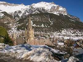 A view of Vallouise in winter | |
 Vallouise-Pelvoux Location within Provence-A.-C.d'A. region  Vallouise-Pelvoux | |
| Coordinates: 44°51′54″N 6°29′20″E / 44.865°N 6.489°ECoordinates: 44°51′54″N 6°29′20″E / 44.865°N 6.489°E | |
| Country | France |
| Region | Provence-Alpes-Côte d'Azur |
| Department | Hautes-Alpes |
| Arrondissement | Briançon |
| Canton | L'Argentière-la-Bessée |
| Intercommunality | Pays des Écrins |
| Area1 | 144.81 km2 (55.91 sq mi) |
| Population (2013)2 | 1,275 |
| • Density | 8.8/km2 (23/sq mi) |
| Time zone | UTC+1 (CET) |
| • Summer (DST) | UTC+2 (CEST) |
| INSEE/Postal code | 05101 /05290, 05340 |
|
1 French Land Register data, which excludes lakes, ponds, glaciers > 1 km2 (0.386 sq mi or 247 acres) and river estuaries. 2 Population without double counting: residents of multiple communes (e.g., students and military personnel) only counted once. | |
Vallouise-Pelvoux is a commune in the department of Hautes-Alpes, southeastern France. The municipality was established on 1 January 2017 by merger of the former communes of Pelvoux (the seat) and Vallouise.[1]
See also
References
| Wikimedia Commons has media related to Vallouise-Pelvoux. |
- ↑ Arrêté préfectoral 5 September 2016 (in French)
This article is issued from
Wikipedia.
The text is licensed under Creative Commons - Attribution - Sharealike.
Additional terms may apply for the media files.