Montmaur, Hautes-Alpes
| Montmaur | ||
|---|---|---|
| Commune | ||
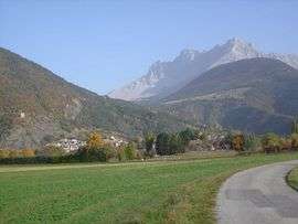 An overall view of Montmaur | ||
| ||
 Montmaur Location within Provence-A.-C.d'A. region  Montmaur | ||
| Coordinates: 44°34′19″N 5°52′29″E / 44.5719°N 5.8747°ECoordinates: 44°34′19″N 5°52′29″E / 44.5719°N 5.8747°E | ||
| Country | France | |
| Region | Provence-Alpes-Côte d'Azur | |
| Department | Hautes-Alpes | |
| Arrondissement | Gap | |
| Canton | Veynes | |
| Intercommunality | Deux Buëch | |
| Government | ||
| • Mayor (2008–2014) | Georges Lesbros | |
| Area1 | 48.77 km2 (18.83 sq mi) | |
| Population (2008)2 | 510 | |
| • Density | 10/km2 (27/sq mi) | |
| Time zone | UTC+1 (CET) | |
| • Summer (DST) | UTC+2 (CEST) | |
| INSEE/Postal code | 05087 /05400 | |
| Elevation |
849–2,680 m (2,785–8,793 ft) (avg. 873 m or 2,864 ft) | |
|
1 French Land Register data, which excludes lakes, ponds, glaciers > 1 km2 (0.386 sq mi or 247 acres) and river estuaries. 2 Population without double counting: residents of multiple communes (e.g., students and military personnel) only counted once. | ||

Montmaur is a commune in the Hautes-Alpes department in southeastern France.
Population
| Historical population | ||
|---|---|---|
| Year | Pop. | ±% |
| 1962 | 190 | — |
| 1968 | 277 | +45.8% |
| 1975 | 229 | −17.3% |
| 1982 | 282 | +23.1% |
| 1990 | 311 | +10.3% |
| 1999 | 423 | +36.0% |
| 2008 | 510 | +20.6% |
See also
References
| Wikimedia Commons has media related to Montmaur, Hautes-Alpes. |
This article is issued from
Wikipedia.
The text is licensed under Creative Commons - Attribution - Sharealike.
Additional terms may apply for the media files.