La Bâtie-Vieille
| La Bâtie-Vieille | |
|---|---|
| Commune | |
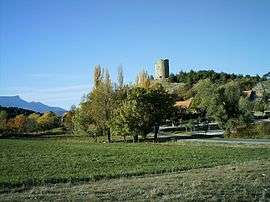 The 12th century tower overlooks the village | |
 La Bâtie-Vieille Location within Provence-A.-C.d'A. region  La Bâtie-Vieille | |
| Coordinates: 44°33′17″N 6°09′46″E / 44.5547°N 6.1628°ECoordinates: 44°33′17″N 6°09′46″E / 44.5547°N 6.1628°E | |
| Country | France |
| Region | Provence-Alpes-Côte d'Azur |
| Department | Hautes-Alpes |
| Arrondissement | Gap |
| Canton | Tallard |
| Intercommunality | Avance |
| Government | |
| • Mayor (2008–2014) | Patrick Galvain |
| Area1 | 9.05 km2 (3.49 sq mi) |
| Population (2008)2 | 268 |
| • Density | 30/km2 (77/sq mi) |
| Time zone | UTC+1 (CET) |
| • Summer (DST) | UTC+2 (CEST) |
| INSEE/Postal code | 05018 /05000 |
| Elevation |
798–1,152 m (2,618–3,780 ft) (avg. 1,030 m or 3,380 ft) |
|
1 French Land Register data, which excludes lakes, ponds, glaciers > 1 km2 (0.386 sq mi or 247 acres) and river estuaries. 2 Population without double counting: residents of multiple communes (e.g., students and military personnel) only counted once. | |
La Bâtie-Vieille is a commune in the Hautes-Alpes department in southeastern France.
Location
The village is 5 km (3.1 mi) away from La Bâtie-Neuve, 8 km from Gap, 11 km (6.8 mi) from Chorges and 21 km (13 mi) from Tallard.
Population
| Historical population | ||
|---|---|---|
| Year | Pop. | ±% |
| 1793 | 199 | — |
| 1800 | 200 | +0.5% |
| 1806 | 228 | +14.0% |
| 1821 | 234 | +2.6% |
| 1831 | 157 | −32.9% |
| 1836 | 232 | +47.8% |
| 1841 | 247 | +6.5% |
| 1846 | 268 | +8.5% |
| 1851 | 238 | −11.2% |
| 1856 | 230 | −3.4% |
| 1861 | 198 | −13.9% |
| 1866 | 197 | −0.5% |
| 1872 | 213 | +8.1% |
| 1876 | 217 | +1.9% |
| 1881 | 208 | −4.1% |
| 1886 | 210 | +1.0% |
| 1891 | 195 | −7.1% |
| 1896 | 207 | +6.2% |
| 1901 | 197 | −4.8% |
| 1906 | 187 | −5.1% |
| 1911 | 171 | −8.6% |
| 1921 | 131 | −23.4% |
| 1926 | 139 | +6.1% |
| 1931 | 149 | +7.2% |
| 1936 | 131 | −12.1% |
| 1946 | 118 | −9.9% |
| 1954 | 123 | +4.2% |
| 1962 | 107 | −13.0% |
| 1968 | 106 | −0.9% |
| 1975 | 89 | −16.0% |
| 1982 | 166 | +86.5% |
| 1990 | 208 | +25.3% |
| 1999 | 246 | +18.3% |
| 2008 | 268 | +8.9% |
See also
References
| Wikimedia Commons has media related to La Bâtie-Vieille. |
This article is issued from
Wikipedia.
The text is licensed under Creative Commons - Attribution - Sharealike.
Additional terms may apply for the media files.