Chabestan
| Chabestan | ||
|---|---|---|
| Commune | ||
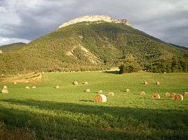 The Roc de Longue Dent | ||
| ||
 Chabestan Location within Provence-A.-C.d'A. region  Chabestan | ||
| Coordinates: 44°28′44″N 5°47′02″E / 44.4789°N 5.7839°ECoordinates: 44°28′44″N 5°47′02″E / 44.4789°N 5.7839°E | ||
| Country | France | |
| Region | Provence-Alpes-Côte d'Azur | |
| Department | Hautes-Alpes | |
| Arrondissement | Gap | |
| Canton | Serres | |
| Intercommunality | Deux Buëch | |
| Government | ||
| • Mayor (2001–2008) | Roger Fournel | |
| Area1 | 12.2 km2 (4.7 sq mi) | |
| Population (2008)2 | 131 | |
| • Density | 11/km2 (28/sq mi) | |
| Time zone | UTC+1 (CET) | |
| • Summer (DST) | UTC+2 (CEST) | |
| INSEE/Postal code | 05028 /05400 | |
| Elevation |
715–1,360 m (2,346–4,462 ft) (avg. 734 m or 2,408 ft) | |
|
1 French Land Register data, which excludes lakes, ponds, glaciers > 1 km2 (0.386 sq mi or 247 acres) and river estuaries. 2 Population without double counting: residents of multiple communes (e.g., students and military personnel) only counted once. | ||

Chabestan is a commune in the Hautes-Alpes department in southeastern France.
Population
| Historical population | ||
|---|---|---|
| Year | Pop. | ±% |
| 1962 | 101 | — |
| 1968 | 113 | +11.9% |
| 1975 | 101 | −10.6% |
| 1982 | 105 | +4.0% |
| 1990 | 112 | +6.7% |
| 1999 | 126 | +12.5% |
| 2008 | 131 | +4.0% |
See also
References
| Wikimedia Commons has media related to Chabestan. |
This article is issued from
Wikipedia.
The text is licensed under Creative Commons - Attribution - Sharealike.
Additional terms may apply for the media files.