La Roche-des-Arnauds
| La Roche-des-Arnauds | ||
|---|---|---|
| Commune | ||
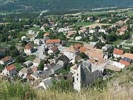 An overhead view of La Roche-des-Arnauds, from the nearby hillside | ||
| ||
 La Roche-des-Arnauds Location within Provence-A.-C.d'A. region  La Roche-des-Arnauds | ||
| Coordinates: 44°33′50″N 5°57′25″E / 44.5639°N 5.9569°ECoordinates: 44°33′50″N 5°57′25″E / 44.5639°N 5.9569°E | ||
| Country | France | |
| Region | Provence-Alpes-Côte d'Azur | |
| Department | Hautes-Alpes | |
| Arrondissement | Gap | |
| Canton | Veynes | |
| Intercommunality | Deux Buëch | |
| Government | ||
| • Mayor (2008–2014) | Maurice Chautant | |
| Area1 | 53.75 km2 (20.75 sq mi) | |
| Population (2008)2 | 1,347 | |
| • Density | 25/km2 (65/sq mi) | |
| Time zone | UTC+1 (CET) | |
| • Summer (DST) | UTC+2 (CEST) | |
| INSEE/Postal code | 05123 /05400 | |
| Elevation |
885–2,709 m (2,904–8,888 ft) (avg. 933 m or 3,061 ft) | |
|
1 French Land Register data, which excludes lakes, ponds, glaciers > 1 km2 (0.386 sq mi or 247 acres) and river estuaries. 2 Population without double counting: residents of multiple communes (e.g., students and military personnel) only counted once. | ||

La Roche-des-Arnauds (Occitan: La Ròca deis Arnauds) is a commune in the Hautes-Alpes department in southeastern France.
Population
| Historical population | ||
|---|---|---|
| Year | Pop. | ±% |
| 1962 | 544 | — |
| 1968 | 607 | +11.6% |
| 1975 | 678 | +11.7% |
| 1982 | 763 | +12.5% |
| 1990 | 845 | +10.7% |
| 1999 | 953 | +12.8% |
| 2008 | 1,347 | +41.3% |
See also
References
| Wikimedia Commons has media related to La Roche-des-Arnauds. |
This article is issued from
Wikipedia.
The text is licensed under Creative Commons - Attribution - Sharealike.
Additional terms may apply for the media files.