Embrun, Hautes-Alpes
| Embrun | ||
|---|---|---|
| Commune | ||
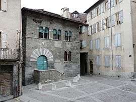 House of the Chanonges (13th century). | ||
| ||
 Embrun Location within Provence-A.-C.d'A. region  Embrun | ||
| Coordinates: 44°33′57″N 6°29′46″E / 44.5658°N 6.4961°ECoordinates: 44°33′57″N 6°29′46″E / 44.5658°N 6.4961°E | ||
| Country | France | |
| Region | Provence-Alpes-Côte d'Azur | |
| Department | Hautes-Alpes | |
| Arrondissement | Gap | |
| Canton | Embrun | |
| Intercommunality | Embrun | |
| Government | ||
| • Mayor (2014–2020) | Chantal Eyméoud (NC) | |
| Area1 | 36.390 km2 (14.050 sq mi) | |
| Population (2013)2 | 6,123 | |
| • Density | 170/km2 (440/sq mi) | |
| Time zone | UTC+1 (CET) | |
| • Summer (DST) | UTC+2 (CEST) | |
| INSEE/Postal code | 05046 /05200 | |
| Elevation |
778–2,800 m (2,552–9,186 ft) (avg. 871 m or 2,858 ft) | |
|
1 French Land Register data, which excludes lakes, ponds, glaciers > 1 km2 (0.386 sq mi or 247 acres) and river estuaries. 2 Population without double counting: residents of multiple communes (e.g., students and military personnel) only counted once. | ||
.svg.png)
Embrun (Occitan: Ambrun, Latin: Ebrodunum, Ebrudunum,[1] and Eburodunum[1][2]) is a commune in the Hautes-Alpes department in the Provence-Alpes-Côte d'Azur region in southeastern France.
Description
It is located between Gap and Briançon and at the eastern end of one of the largest artificial lakes in Western Europe: the Lac de Serre-Ponçon.
The Canadian town of Embrun, Ontario was named after Embrun in 1856.
History
Embrun was formerly known as Ebrodunum (Ἐβρόδουνον in Greek language sources). There is some variation in the writing of the first part of the name. It is Epebrodunum in Strabo's text, but later translators corrected it. Strabo (iv.) says that from Tarasco to the borders of the Vocontii and the beginning of the ascent of the Alps, through the Druentia and Caballio, is 63 miles; and from thence to the other boundaries of the Vocontii, to the kingdom of Cottius (the Alpes Cottiae), to the village of Ebrodunum, 99 miles. Ebrodunum was in the civitas (tribal state) of the Caturiges, and just on the borders of the Vocontii, as it appears.
The position of Ebrodunum is easily determined by the itineraries and the name. Ptolemy (iii. 1) mentions Eborodunum as the city of the Caturiges, and no other. In the Jerusalem Itinerary Ebrodunum is called Mansio, like Caturiges (modern Chorges), which was also in the territory of the Caturiges. There are Roman remains at Chorges, and none are mentioned at Embrun, though it appears that the cathedral of Embrun is built on the site of a Roman temple, or that some of the materials of a temple were used for it.
Ebrodunum was, for a time, the capital of the Roman province of Alpes Maritimae.
In the feudal age, it was an important (archi)episcopal see.
In stage 17 of the 2013 Tour de France, Embrun was the starting point for an individual time trial. In 2017, stage 19 of the Tour de France started at Embrun. [3]
Ecclesiastical history
Embrun was the see of a bishopric since the fourth century, which became a Metropolitan archbishopric in the fourteenth and was suppressed in the French Revolution.
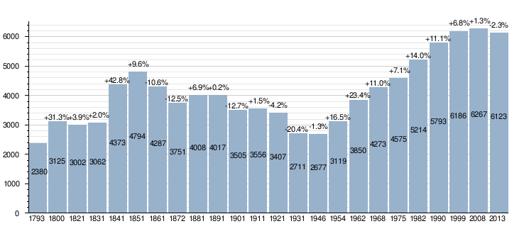
Demographic evolution
Climate
| Climate data for Embrun, Hautes-Alpes (1981–2010 averages) | |||||||||||||
|---|---|---|---|---|---|---|---|---|---|---|---|---|---|
| Month | Jan | Feb | Mar | Apr | May | Jun | Jul | Aug | Sep | Oct | Nov | Dec | Year |
| Record high °C (°F) | 19.0 (66.2) |
21.3 (70.3) |
24.3 (75.7) |
28.4 (83.1) |
31.8 (89.2) |
33.9 (93) |
36.7 (98.1) |
36.1 (97) |
33.5 (92.3) |
27.5 (81.5) |
22.5 (72.5) |
17.7 (63.9) |
36.7 (98.1) |
| Average high °C (°F) | 6.8 (44.2) |
8.4 (47.1) |
12.4 (54.3) |
15.2 (59.4) |
19.7 (67.5) |
23.8 (74.8) |
27.3 (81.1) |
27.0 (80.6) |
22.3 (72.1) |
17.1 (62.8) |
10.8 (51.4) |
7.1 (44.8) |
16.5 (61.7) |
| Average low °C (°F) | −2.8 (27) |
−2.5 (27.5) |
0.6 (33.1) |
3.4 (38.1) |
7.5 (45.5) |
10.6 (51.1) |
13.1 (55.6) |
12.9 (55.2) |
9.6 (49.3) |
6.2 (43.2) |
1.1 (34) |
−1.7 (28.9) |
4.9 (40.8) |
| Record low °C (°F) | −19.1 (−2.4) |
−18.8 (−1.8) |
−13.9 (7) |
−6.3 (20.7) |
−3.2 (26.2) |
−0.8 (30.6) |
3.4 (38.1) |
3.4 (38.1) |
−0.4 (31.3) |
−5.3 (22.5) |
−11.2 (11.8) |
−15.6 (3.9) |
−19.1 (−2.4) |
| Average precipitation mm (inches) | 51.9 (2.043) |
45.1 (1.776) |
50.1 (1.972) |
61.2 (2.409) |
68.0 (2.677) |
61.0 (2.402) |
46.8 (1.843) |
51.9 (2.043) |
69.0 (2.717) |
85.8 (3.378) |
69.0 (2.717) |
66.7 (2.626) |
726.5 (28.602) |
| Average precipitation days | 5.8 | 5.0 | 6.2 | 8.0 | 9.4 | 8.2 | 5.8 | 6.7 | 6.6 | 8.4 | 6.7 | 6.7 | 83.6 |
| Average snowy days | 8.4 | 7.3 | 5.6 | 2.4 | 0.2 | 0.0 | 0.0 | 0.0 | 0.0 | 0.2 | 3.0 | 6.2 | 33.3 |
| Average relative humidity (%) | 66 | 64 | 61 | 61 | 64 | 65 | 59 | 62 | 66 | 68 | 68 | 66 | 64.2 |
| Mean monthly sunshine hours | 160.1 | 178.8 | 225.8 | 208.0 | 222.4 | 263.9 | 292.1 | 268.7 | 227.1 | 181.1 | 144.5 | 138.6 | 2,510.9 |
| Source #1: Meteo France[4][5] | |||||||||||||
| Source #2: Infoclimat.fr (humidity, snowy days 1961–1990)[6] | |||||||||||||
See also
References
- 1 2 Richard Talbert, Barrington Atlas of the Greek and Roman World, ( ISBN 0-691-03169-X), Map 17 and notes.
- ↑ Arthur James Johnes (1843). Philological Proofs of the Original Unity and Recent Origin of the Human Race: Derived from a Comparison of the Languages of Asia, Europe, Africa, and America. Being an Inquiry how Far the Differences in the Languages of the Globe are Referrible to Causes Now in Operation. S. Clarke. pp. 75–.
- ↑ http://www.letour.com/us/
- ↑ "Données climatiques de la station de Embrun" (in French). Meteo France. Retrieved January 14, 2016.
- ↑ "Climat Provence-Alpes-Côte d'Azur" (in French). Meteo France. Retrieved January 14, 2016.
- ↑ "Normes et records 1961-1990: Embrun (05) - altitude 871m" (in French). Infoclimat. Retrieved January 14, 2016.


External links

- INSEE
- Embrun Office of Tourism (in French).