Vallouise
| Vallouise | ||
|---|---|---|
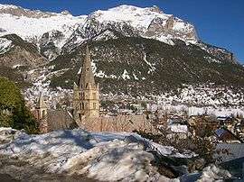 The church and surrounding buildings in Vallouise, in winter | ||
| ||
 Vallouise Location within Provence-A.-C.d'A. region  Vallouise | ||
| Coordinates: 44°50′45″N 6°29′15″E / 44.8458°N 6.4875°ECoordinates: 44°50′45″N 6°29′15″E / 44.8458°N 6.4875°E | ||
| Country | France | |
| Region | Provence-Alpes-Côte d'Azur | |
| Department | Hautes-Alpes | |
| Arrondissement | Briançon | |
| Canton | L'Argentière-la-Bessée | |
| Area1 | 68.58 km2 (26.48 sq mi) | |
| Population (2008)2 | 728 | |
| • Density | 11/km2 (27/sq mi) | |
| Time zone | UTC+1 (CET) | |
| • Summer (DST) | UTC+2 (CEST) | |
| INSEE/Postal code | 05175 /05290 | |
| Elevation |
1,106–3,667 m (3,629–12,031 ft) (avg. 1,150 m or 3,770 ft) | |
|
1 French Land Register data, which excludes lakes, ponds, glaciers > 1 km2 (0.386 sq mi or 247 acres) and river estuaries. 2 Population without double counting: residents of multiple communes (e.g., students and military personnel) only counted once. | ||

Vallouise is a former commune in the Hautes-Alpes department in southeastern France. On 1 January 2017, it was merged into the new commune Vallouise-Pelvoux.[1]
Population
| Historical population | ||
|---|---|---|
| Year | Pop. | ±% |
| 1962 | 381 | — |
| 1968 | 417 | +9.4% |
| 1975 | 451 | +8.2% |
| 1982 | 512 | +13.5% |
| 1990 | 623 | +21.7% |
| 1999 | 637 | +2.2% |
| 2008 | 728 | +14.3% |
See also
References
- ↑ Arrêté préfectoral 5 September 2016 (in French)
| Wikimedia Commons has media related to Vallouise. |
This article is issued from
Wikipedia.
The text is licensed under Creative Commons - Attribution - Sharealike.
Additional terms may apply for the media files.