Saint-Clément-sur-Durance
| Saint-Clément-sur-Durance | ||
|---|---|---|
| Commune | ||
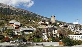 The village of Saint-Clément-sur-Durance | ||
| ||
 Saint-Clément-sur-Durance Location within Provence-A.-C.d'A. region  Saint-Clément-sur-Durance | ||
| Coordinates: 44°38′59″N 6°34′45″E / 44.6497°N 6.5792°ECoordinates: 44°38′59″N 6°34′45″E / 44.6497°N 6.5792°E | ||
| Country | France | |
| Region | Provence-Alpes-Côte d'Azur | |
| Department | Hautes-Alpes | |
| Arrondissement | Briançon | |
| Canton | Guillestre | |
| Intercommunality | Guillestre | |
| Government | ||
| • Mayor (2008–2014) | Jean-Louis Berard | |
| Area1 | 25.06 km2 (9.68 sq mi) | |
| Population (2008)2 | 276 | |
| • Density | 11/km2 (29/sq mi) | |
| Time zone | UTC+1 (CET) | |
| • Summer (DST) | UTC+2 (CEST) | |
| INSEE/Postal code | 05134 /05600 | |
| Elevation |
858–2,836 m (2,815–9,304 ft) (avg. 872 m or 2,861 ft) | |
|
1 French Land Register data, which excludes lakes, ponds, glaciers > 1 km2 (0.386 sq mi or 247 acres) and river estuaries. 2 Population without double counting: residents of multiple communes (e.g., students and military personnel) only counted once. | ||

Saint-Clément-sur-Durance is a commune in the Hautes-Alpes department in southeastern France.
Population
| Historical population | ||
|---|---|---|
| Year | Pop. | ±% |
| 1962 | 189 | — |
| 1968 | 227 | +20.1% |
| 1975 | 195 | −14.1% |
| 1982 | 205 | +5.1% |
| 1990 | 191 | −6.8% |
| 1999 | 229 | +19.9% |
| 2008 | 276 | +20.5% |
See also
References
| Wikimedia Commons has media related to Saint-Clément-sur-Durance. |
This article is issued from
Wikipedia.
The text is licensed under Creative Commons - Attribution - Sharealike.
Additional terms may apply for the media files.