Puy-Saint-Pierre
| Puy-Saint-Pierre | |
|---|---|
| Commune | |
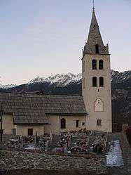 The church of Puy-Saint-Pierre, in early 2007 | |
 Puy-Saint-Pierre Location within Provence-A.-C.d'A. region  Puy-Saint-Pierre | |
| Coordinates: 44°53′38″N 6°37′07″E / 44.8939°N 6.6186°ECoordinates: 44°53′38″N 6°37′07″E / 44.8939°N 6.6186°E | |
| Country | France |
| Region | Provence-Alpes-Côte d'Azur |
| Department | Hautes-Alpes |
| Arrondissement | Briançon |
| Canton | Briançon-1 |
| Government | |
| • Mayor (2008–2014) | Jean-Marius Barneoud |
| Area1 | 7.74 km2 (2.99 sq mi) |
| Population (2008)2 | 500 |
| • Density | 65/km2 (170/sq mi) |
| Time zone | UTC+1 (CET) |
| • Summer (DST) | UTC+2 (CEST) |
| INSEE/Postal code | 05109 /05100 |
| Elevation |
1,237–2,538 m (4,058–8,327 ft) (avg. 1,024 m or 3,360 ft) |
|
1 French Land Register data, which excludes lakes, ponds, glaciers > 1 km2 (0.386 sq mi or 247 acres) and river estuaries. 2 Population without double counting: residents of multiple communes (e.g., students and military personnel) only counted once. | |
Puy-Saint-Pierre is a commune in the Hautes-Alpes department in southeastern France.
Population
| Historical population | ||
|---|---|---|
| Year | Pop. | ±% |
| 1962 | 227 | — |
| 1968 | 229 | +0.9% |
| 1975 | 254 | +10.9% |
| 1982 | 307 | +20.9% |
| 1990 | 344 | +12.1% |
| 1999 | 354 | +2.9% |
| 2008 | 500 | +41.2% |
See also
References
| Wikimedia Commons has media related to Puy-Saint-Pierre. |
This article is issued from
Wikipedia.
The text is licensed under Creative Commons - Attribution - Sharealike.
Additional terms may apply for the media files.