Saint-Julien-en-Beauchêne
| Saint-Julien-en-Beauchêne | |
|---|---|
| Commune | |
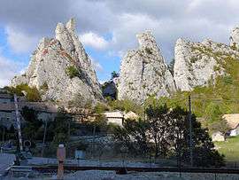 The commune of Saint-Julien-en-Beauchêne, with the hamlet of La Rochette and the Alpine railway line | |
 Saint-Julien-en-Beauchêne Location within Provence-A.-C.d'A. region  Saint-Julien-en-Beauchêne | |
| Coordinates: 44°37′01″N 5°42′37″E / 44.6169°N 5.7103°ECoordinates: 44°37′01″N 5°42′37″E / 44.6169°N 5.7103°E | |
| Country | France |
| Region | Provence-Alpes-Côte d'Azur |
| Department | Hautes-Alpes |
| Arrondissement | Gap |
| Canton | Serres |
| Intercommunality | Haut Buëch |
| Government | |
| • Mayor (2008–2014) | Jean-Claude Gast |
| Area1 | 59.43 km2 (22.95 sq mi) |
| Population (2008)2 | 124 |
| • Density | 2.1/km2 (5.4/sq mi) |
| Time zone | UTC+1 (CET) |
| • Summer (DST) | UTC+2 (CEST) |
| INSEE/Postal code | 05146 /05140 |
| Elevation |
847–2,365 m (2,779–7,759 ft) (avg. 922 m or 3,025 ft) |
|
1 French Land Register data, which excludes lakes, ponds, glaciers > 1 km2 (0.386 sq mi or 247 acres) and river estuaries. 2 Population without double counting: residents of multiple communes (e.g., students and military personnel) only counted once. | |
Saint-Julien-en-Beauchêne is a commune in the Hautes-Alpes department in southeastern France.
It is popular for skiing during the winter and for walks in the mountains during the summer.
Population
| Historical population | ||
|---|---|---|
| Year | Pop. | ±% |
| 1962 | 97 | — |
| 1968 | 139 | +43.3% |
| 1975 | 101 | −27.3% |
| 1982 | 114 | +12.9% |
| 1990 | 120 | +5.3% |
| 1999 | 108 | −10.0% |
| 2008 | 124 | +14.8% |
See also
References
| Wikimedia Commons has media related to Saint-Julien-en-Beauchêne. |
This article is issued from
Wikipedia.
The text is licensed under Creative Commons - Attribution - Sharealike.
Additional terms may apply for the media files.